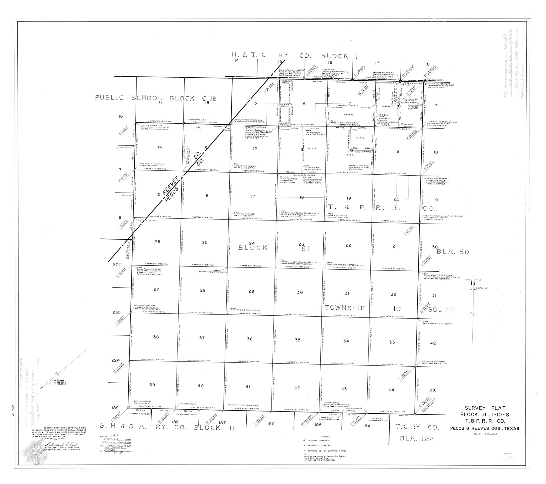
Pecos County Rolled Sketch 152
Survey plat, Block 51, T-10-S, T. & P. R.R. Co., Pecos & Reeves Cos., Texas
-
Map/Doc
9736
-
Collection
General Map Collection
-
Object Dates
1960 (Creation Date)
1960/2/17 (File Date)
-
People and Organizations
Clifford C. Cool (Surveyor/Engineer)
-
Counties
Pecos Reeves
-
Subjects
Surveying Rolled Sketch
-
Height x Width
38.8 x 43.7 inches
98.6 x 111.0 cm
-
Scale
1" = 500 varas
Part of: General Map Collection
Bee County Sketch File 7

Print $8.00
- Digital $50.00
Bee County Sketch File 7
1873
Size 10.1 x 8.0 inches
Map/Doc 14275
Navigation Maps of Gulf Intracoastal Waterway, Port Arthur to Brownsville, Texas

Print $4.00
- Digital $50.00
Navigation Maps of Gulf Intracoastal Waterway, Port Arthur to Brownsville, Texas
1951
Size 16.6 x 21.5 inches
Map/Doc 65436
Wheeler County Working Sketch 7

Print $40.00
- Digital $50.00
Wheeler County Working Sketch 7
1972
Size 50.1 x 42.9 inches
Map/Doc 72496
Flight Mission No. CRC-4R, Frame 185, Chambers County

Print $20.00
- Digital $50.00
Flight Mission No. CRC-4R, Frame 185, Chambers County
1956
Size 18.5 x 22.2 inches
Map/Doc 84936
Old Miscellaneous File 6

Print $4.00
- Digital $50.00
Old Miscellaneous File 6
1847
Size 4.2 x 7.6 inches
Map/Doc 75420
Gregg County Sketch File 2

Print $26.00
- Digital $50.00
Gregg County Sketch File 2
1921
Size 14.2 x 8.7 inches
Map/Doc 24553
Pecos County Sketch File 85

Print $19.00
- Digital $50.00
Pecos County Sketch File 85
1948
Size 14.6 x 9.2 inches
Map/Doc 33955
Burnet County Sketch File 17

Print $6.00
- Digital $50.00
Burnet County Sketch File 17
Size 12.4 x 10.1 inches
Map/Doc 16706
Jeff Davis County Sketch File 19

Print $10.00
- Digital $50.00
Jeff Davis County Sketch File 19
1908
Size 14.4 x 8.8 inches
Map/Doc 27973
Brewster County Rolled Sketch 66

Print $20.00
- Digital $50.00
Brewster County Rolled Sketch 66
1940
Size 33.0 x 36.2 inches
Map/Doc 8490
Harris County Sketch File 84

Print $20.00
- Digital $50.00
Harris County Sketch File 84
1950
Size 23.1 x 35.7 inches
Map/Doc 11672
Hansford County Working Sketch 5

Print $20.00
- Digital $50.00
Hansford County Working Sketch 5
1967
Size 30.2 x 28.3 inches
Map/Doc 63377
You may also like
Culberson County Working Sketch 72

Print $40.00
- Digital $50.00
Culberson County Working Sketch 72
1975
Size 50.1 x 34.2 inches
Map/Doc 68526
[Plat showing traverse line run from I. R. Rock at southeast corner survey 58 northerly to the I. R. Rock corner at the northeast 60]
![91598, [Plat showing traverse line run from I. R. Rock at southeast corner survey 58 northerly to the I. R. Rock corner at the northeast 60], Twichell Survey Records](https://historictexasmaps.com/wmedia_w700/maps/91598-1.tif.jpg)
Print $20.00
- Digital $50.00
[Plat showing traverse line run from I. R. Rock at southeast corner survey 58 northerly to the I. R. Rock corner at the northeast 60]
1935
Size 21.7 x 18.0 inches
Map/Doc 91598
Young County Sketch File 17

Print $20.00
- Digital $50.00
Young County Sketch File 17
Size 18.5 x 24.3 inches
Map/Doc 12713
Gulf of Mexico

Print $20.00
- Digital $50.00
Gulf of Mexico
1908
Size 18.3 x 26.9 inches
Map/Doc 72655
Crockett County Rolled Sketch 42

Print $20.00
- Digital $50.00
Crockett County Rolled Sketch 42
Size 24.4 x 24.7 inches
Map/Doc 5592
Swisher County

Print $20.00
- Digital $50.00
Swisher County
1941
Size 44.3 x 38.1 inches
Map/Doc 73297
Map of Tyler County, Texas

Print $20.00
- Digital $50.00
Map of Tyler County, Texas
1881
Size 22.3 x 24.2 inches
Map/Doc 762
Dimmit County Sketch File 22

Print $47.00
- Digital $50.00
Dimmit County Sketch File 22
1906
Size 9.3 x 8.6 inches
Map/Doc 21129
Corpus Christi Bay

Print $20.00
- Digital $50.00
Corpus Christi Bay
1961
Size 36.0 x 47.4 inches
Map/Doc 73471
Glasscock County, Texas

Print $20.00
- Digital $50.00
Glasscock County, Texas
1889
Size 21.7 x 18.1 inches
Map/Doc 730
Jackson County Sketch File 10x

Print $40.00
- Digital $50.00
Jackson County Sketch File 10x
1914
Size 13.8 x 12.0 inches
Map/Doc 27656
Current Miscellaneous File 105

Print $18.00
- Digital $50.00
Current Miscellaneous File 105
Size 8.8 x 14.2 inches
Map/Doc 74680