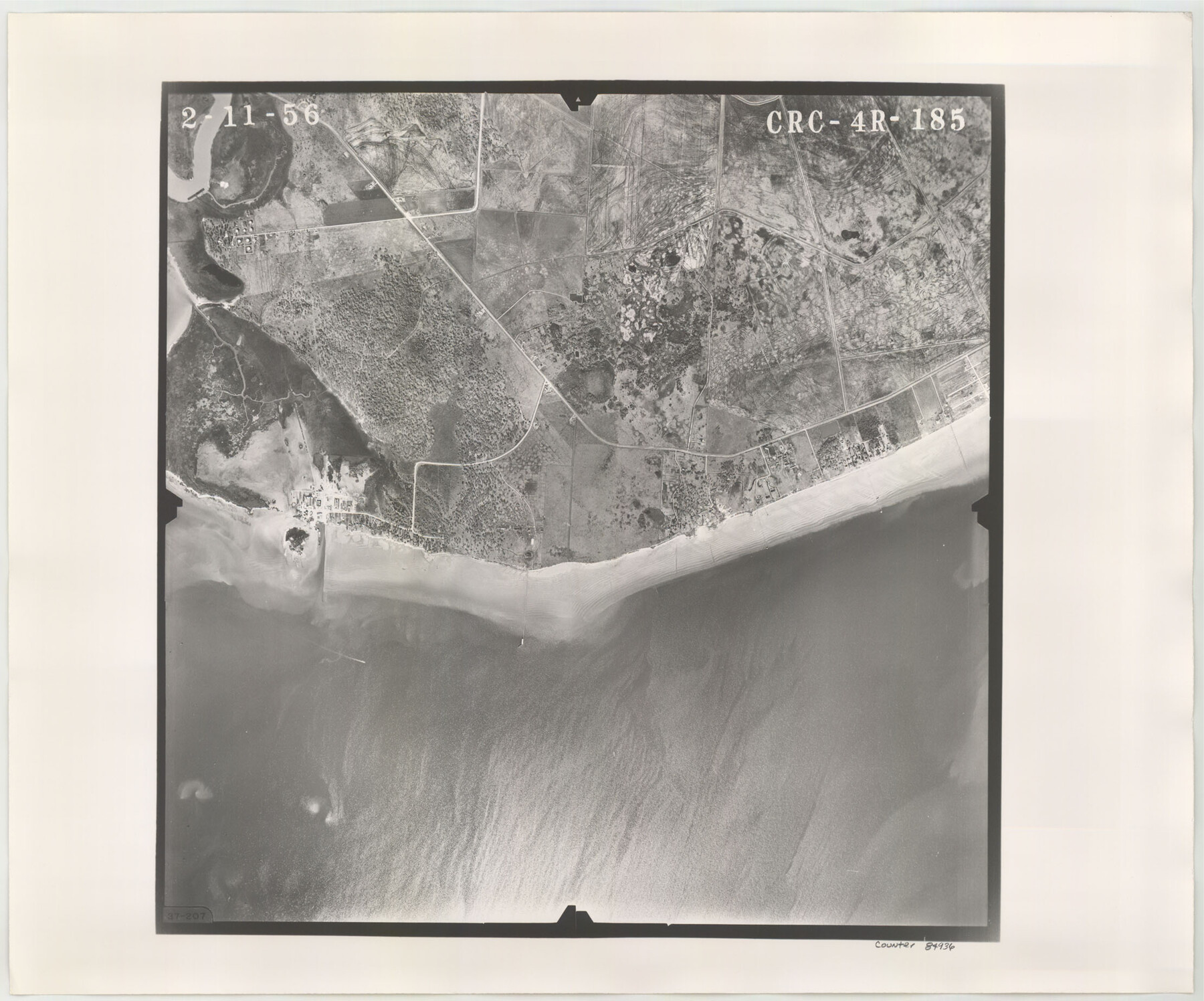
Flight Mission No. CRC-4R, Frame 185, Chambers County
CRC-4R-185
-
Map/Doc
84936
-
Collection
General Map Collection
-
Object Dates
1956/2/11 (Creation Date)
-
People and Organizations
U. S. Department of Agriculture (Publisher)
-
Counties
Chambers
-
Subjects
Aerial Photograph
-
Height x Width
18.5 x 22.2 inches
47.0 x 56.4 cm
-
Comments
Flown by Jack Ammann Photogrammetric Engineers, Inc. of San Antonio, Texas.
Part of: General Map Collection
Jefferson County Sketch File 54

Print $226.00
- Digital $50.00
Jefferson County Sketch File 54
1961
Size 11.0 x 8.5 inches
Map/Doc 28359
Menard County Sketch File 22

Print $8.00
- Digital $50.00
Menard County Sketch File 22
1927
Size 7.4 x 8.6 inches
Map/Doc 31553
Comanche County Sketch File 29

Print $23.00
- Digital $50.00
Comanche County Sketch File 29
1954
Size 13.4 x 10.2 inches
Map/Doc 19120
Callahan County

Print $20.00
- Digital $50.00
Callahan County
1879
Size 22.0 x 17.9 inches
Map/Doc 3362
Freestone County Working Sketch 28

Print $20.00
- Digital $50.00
Freestone County Working Sketch 28
1981
Size 17.2 x 22.5 inches
Map/Doc 69270
Map Shelby County

Print $20.00
- Digital $50.00
Map Shelby County
1852
Size 20.1 x 31.5 inches
Map/Doc 4029
Dickens County Working Sketch 7

Print $20.00
- Digital $50.00
Dickens County Working Sketch 7
1947
Size 26.1 x 31.1 inches
Map/Doc 68655
[South part of Lamar County]
![76045, [South part of Lamar County], General Map Collection](https://historictexasmaps.com/wmedia_w700/maps/76045.tif.jpg)
Print $20.00
- Digital $50.00
[South part of Lamar County]
1844
Size 15.5 x 20.5 inches
Map/Doc 76045
Flight Mission No. BQR-12K, Frame 51, Brazoria County

Print $20.00
- Digital $50.00
Flight Mission No. BQR-12K, Frame 51, Brazoria County
1952
Size 18.8 x 22.4 inches
Map/Doc 84066
Hansford County Boundary File 2a

Print $40.00
- Digital $50.00
Hansford County Boundary File 2a
Size 14.2 x 8.7 inches
Map/Doc 54252
[Surveys along Richland Creek]
![320, [Surveys along Richland Creek], General Map Collection](https://historictexasmaps.com/wmedia_w700/maps/320.tif.jpg)
Print $2.00
- Digital $50.00
[Surveys along Richland Creek]
Size 7.2 x 6.0 inches
Map/Doc 320
Texas, Aransas Bay, Aransas Pass to Nine Mile Point

Print $40.00
- Digital $50.00
Texas, Aransas Bay, Aransas Pass to Nine Mile Point
1934
Size 35.2 x 48.4 inches
Map/Doc 73431
You may also like
[Sections 5 through 34]
![92480, [Sections 5 through 34], Twichell Survey Records](https://historictexasmaps.com/wmedia_w700/maps/92480-1.tif.jpg)
Print $20.00
- Digital $50.00
[Sections 5 through 34]
Size 23.9 x 19.4 inches
Map/Doc 92480
Hopkins County Sketch File 15

Print $4.00
- Digital $50.00
Hopkins County Sketch File 15
Size 10.6 x 7.3 inches
Map/Doc 26711
Terrell County Working Sketch 78

Print $20.00
- Digital $50.00
Terrell County Working Sketch 78
1983
Size 41.0 x 37.2 inches
Map/Doc 69599
La Salle County

Print $20.00
- Digital $50.00
La Salle County
1886
Size 25.4 x 21.3 inches
Map/Doc 3795
[Upton County Sketch]
![76176, [Upton County Sketch], Maddox Collection](https://historictexasmaps.com/wmedia_w700/maps/76176.tif.jpg)
Print $40.00
- Digital $50.00
[Upton County Sketch]
Size 19.1 x 60.8 inches
Map/Doc 76176
Palo Pinto County, Texas

Print $20.00
- Digital $50.00
Palo Pinto County, Texas
1871
Size 28.8 x 23.4 inches
Map/Doc 660
Wheeler County Sketch File 1

Print $20.00
- Digital $50.00
Wheeler County Sketch File 1
Size 17.1 x 26.8 inches
Map/Doc 12672
Working Sketch Carson County

Print $3.00
- Digital $50.00
Working Sketch Carson County
1907
Size 10.6 x 17.1 inches
Map/Doc 90223
Bastrop County Working Sketch 8

Print $20.00
- Digital $50.00
Bastrop County Working Sketch 8
1937
Size 23.9 x 43.1 inches
Map/Doc 67308
Stephens County Rolled Sketch 6

Print $20.00
- Digital $50.00
Stephens County Rolled Sketch 6
Size 37.1 x 36.0 inches
Map/Doc 8360
Tyler County Rolled Sketch 12

Print $20.00
- Digital $50.00
Tyler County Rolled Sketch 12
1988
Size 25.2 x 19.3 inches
Map/Doc 8060
Map of Matagorda Bay and County with the Adjacent Country

Print $20.00
- Digital $50.00
Map of Matagorda Bay and County with the Adjacent Country
1839
Size 33.4 x 42.6 inches
Map/Doc 2002