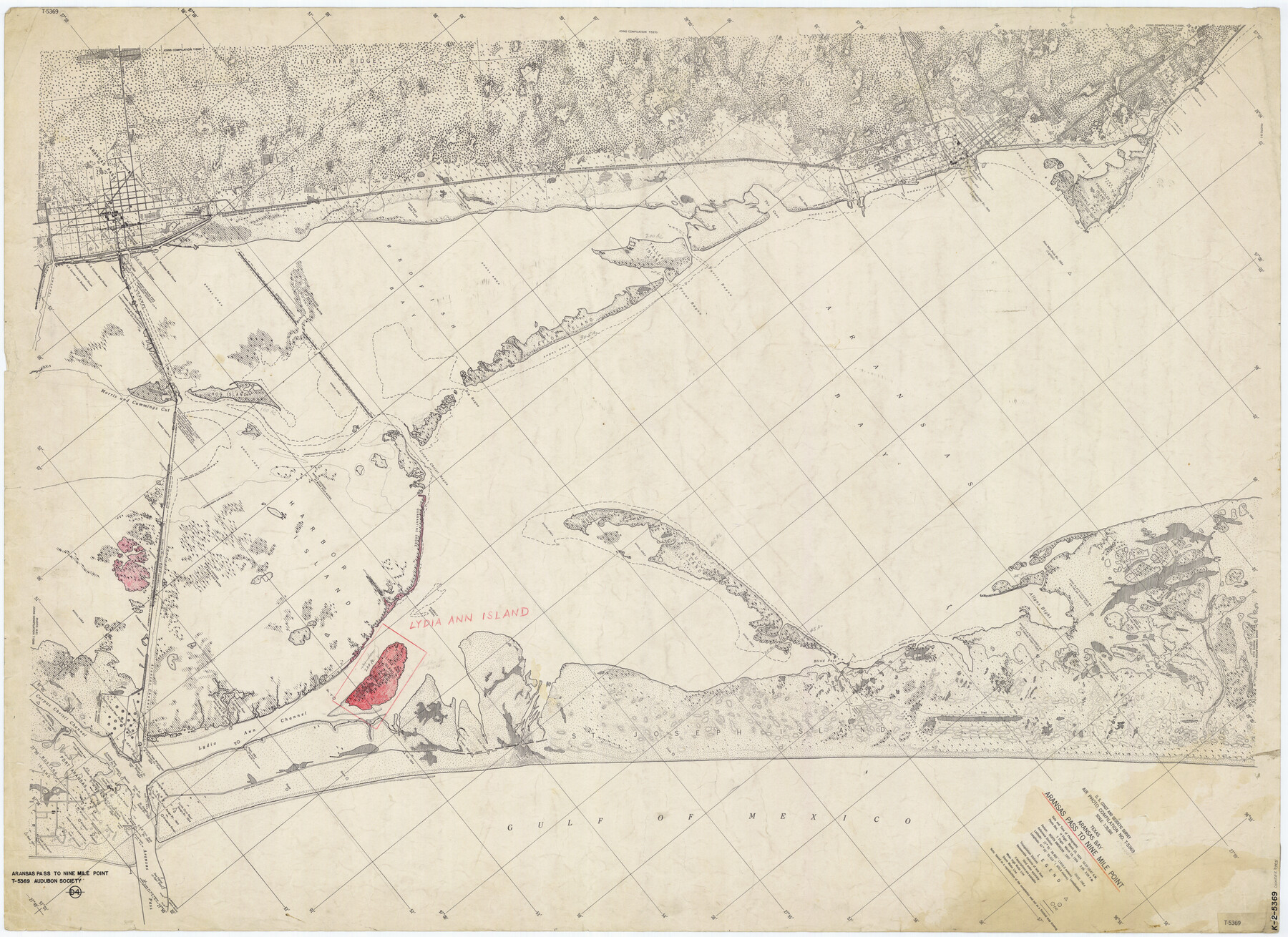
Texas, Aransas Bay, Aransas Pass to Nine Mile Point
K-2-5369
-
Map/Doc
73431
-
Collection
General Map Collection
-
Object Dates
1934 (Creation Date)
-
Counties
San Patricio Aransas Nueces
-
Subjects
Nautical Charts
-
Height x Width
35.2 x 48.4 inches
89.4 x 122.9 cm
Part of: General Map Collection
Goliad County Sketch File 11

Print $40.00
- Digital $50.00
Goliad County Sketch File 11
Size 13.4 x 12.5 inches
Map/Doc 24228
Harris County Sketch File 75

Print $4.00
- Digital $50.00
Harris County Sketch File 75
1948
Size 11.7 x 9.0 inches
Map/Doc 25544
Gaines County Rolled Sketch 12

Print $20.00
- Digital $50.00
Gaines County Rolled Sketch 12
1940
Size 26.6 x 33.8 inches
Map/Doc 5932
Cooke County Sketch File 29

Print $16.00
- Digital $50.00
Cooke County Sketch File 29
1873
Size 8.2 x 11.0 inches
Map/Doc 19283
Corpus Christi Pass, Texas

Print $20.00
- Digital $50.00
Corpus Christi Pass, Texas
1871
Size 26.1 x 18.2 inches
Map/Doc 72980
Tom Green County Sketch File 39

Print $40.00
- Digital $50.00
Tom Green County Sketch File 39
1881
Size 14.8 x 18.6 inches
Map/Doc 76002
Erforschung von Nordwest-Texas

Print $20.00
- Digital $50.00
Erforschung von Nordwest-Texas
1873
Size 11.4 x 9.4 inches
Map/Doc 95144
Cherokee County Working Sketch 5

Print $20.00
- Digital $50.00
Cherokee County Working Sketch 5
1951
Size 22.0 x 23.5 inches
Map/Doc 67960
Garza County Boundary File 2

Print $6.00
- Digital $50.00
Garza County Boundary File 2
Size 14.9 x 9.2 inches
Map/Doc 53673
Dimmit County Working Sketch 30

Print $20.00
- Digital $50.00
Dimmit County Working Sketch 30
1957
Size 22.2 x 26.0 inches
Map/Doc 68691
Rains County Boundary File 71

Print $6.00
- Digital $50.00
Rains County Boundary File 71
Size 8.7 x 3.5 inches
Map/Doc 58094
Flight Mission No. DQO-8K, Frame 16, Galveston County

Print $20.00
- Digital $50.00
Flight Mission No. DQO-8K, Frame 16, Galveston County
1952
Size 18.8 x 22.4 inches
Map/Doc 85139
You may also like
Nolan County Rolled Sketch 3

Print $20.00
- Digital $50.00
Nolan County Rolled Sketch 3
Size 27.9 x 26.2 inches
Map/Doc 6864
Cass County Working Sketch 8

Print $20.00
- Digital $50.00
Cass County Working Sketch 8
1937
Size 20.2 x 16.1 inches
Map/Doc 67911
The Rand McNally New Commercial Atlas Map of Texas

Print $20.00
- Digital $50.00
The Rand McNally New Commercial Atlas Map of Texas
1919
Size 28.4 x 40.2 inches
Map/Doc 95852
Galveston County Rolled Sketch 34B

Print $20.00
- Digital $50.00
Galveston County Rolled Sketch 34B
1978
Size 28.4 x 40.0 inches
Map/Doc 5968
[Blocks XO2, Z, and a Portion of Block 47]
![91252, [Blocks XO2, Z, and a Portion of Block 47], Twichell Survey Records](https://historictexasmaps.com/wmedia_w700/maps/91252-1.tif.jpg)
Print $20.00
- Digital $50.00
[Blocks XO2, Z, and a Portion of Block 47]
1923
Size 19.5 x 9.0 inches
Map/Doc 91252
Richardsons New Map of the State of Texas Including Part of Mexico Compiled from Government Surveys and other Authentic Documents

Print $20.00
Richardsons New Map of the State of Texas Including Part of Mexico Compiled from Government Surveys and other Authentic Documents
1860
Size 26.7 x 34.5 inches
Map/Doc 79735
Ochiltree County Sketch File 3

Print $40.00
- Digital $50.00
Ochiltree County Sketch File 3
1908
Size 15.4 x 12.9 inches
Map/Doc 33177
General Highway Map. Detail of Cities and Towns in Galveston County, Texas [Galveston and vicinity]
![79097, General Highway Map. Detail of Cities and Towns in Galveston County, Texas [Galveston and vicinity], Texas State Library and Archives](https://historictexasmaps.com/wmedia_w700/maps/79097.tif.jpg)
Print $20.00
General Highway Map. Detail of Cities and Towns in Galveston County, Texas [Galveston and vicinity]
1939
Size 18.4 x 25.0 inches
Map/Doc 79097
Map of north end of Brazos Island

Print $20.00
- Digital $50.00
Map of north end of Brazos Island
Size 27.6 x 18.2 inches
Map/Doc 72908
Harrison County Working Sketch 8

Print $20.00
- Digital $50.00
Harrison County Working Sketch 8
1956
Size 20.6 x 30.5 inches
Map/Doc 66028
Travis County Working Sketch 11

Print $20.00
- Digital $50.00
Travis County Working Sketch 11
1919
Size 28.3 x 22.3 inches
Map/Doc 69395
Working Sketch in Lynn County

Print $20.00
- Digital $50.00
Working Sketch in Lynn County
1921
Size 15.3 x 18.6 inches
Map/Doc 91338