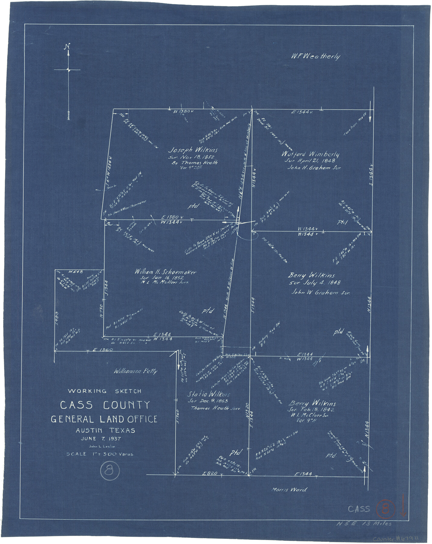
Cass County Working Sketch 8
-
Map/Doc
67911
-
Collection
General Map Collection
-
Object Dates
6/7/1937 (Creation Date)
-
People and Organizations
John L. Leslie (Draftsman)
-
Counties
Cass
-
Subjects
Surveying Working Sketch
-
Height x Width
20.2 x 16.1 inches
51.3 x 40.9 cm
-
Scale
1" = 300 varas
Part of: General Map Collection
Garza County Boundary File 2

Print $6.00
- Digital $50.00
Garza County Boundary File 2
Size 14.9 x 9.2 inches
Map/Doc 53673
Bandera County Working Sketch 56

Print $20.00
- Digital $50.00
Bandera County Working Sketch 56
1991
Size 28.1 x 35.1 inches
Map/Doc 67652
Map of Galveston Harbor and City

Print $40.00
- Digital $50.00
Map of Galveston Harbor and City
1850
Size 31.0 x 52.0 inches
Map/Doc 69856
Cochran County Boundary File 2

Print $59.00
- Digital $50.00
Cochran County Boundary File 2
Size 14.8 x 9.3 inches
Map/Doc 51466
Hunt County Working Sketch 9

Print $20.00
- Digital $50.00
Hunt County Working Sketch 9
1959
Size 33.8 x 30.6 inches
Map/Doc 66356
Galveston Harbor and Channel, Texas - Rehabilitation of Galveston Groins - Location Plan of Rehabilitation

Print $4.00
- Digital $50.00
Galveston Harbor and Channel, Texas - Rehabilitation of Galveston Groins - Location Plan of Rehabilitation
1968
Size 16.0 x 20.6 inches
Map/Doc 73620
Erath County Boundary File 1

Print $8.00
- Digital $50.00
Erath County Boundary File 1
Size 13.1 x 8.8 inches
Map/Doc 53237
Angelina County Sketch File 6

Print $4.00
- Digital $50.00
Angelina County Sketch File 6
1856
Size 8.1 x 8.2 inches
Map/Doc 12933
Wise County Sketch File 7

Print $4.00
- Digital $50.00
Wise County Sketch File 7
1857
Size 8.1 x 14.0 inches
Map/Doc 40535
Scurry County Rolled Sketch 9

Print $20.00
- Digital $50.00
Scurry County Rolled Sketch 9
1963
Size 23.0 x 22.0 inches
Map/Doc 7769
Red River County Working Sketch 56

Print $20.00
- Digital $50.00
Red River County Working Sketch 56
1971
Size 30.1 x 35.2 inches
Map/Doc 72039
Terrell County Sketch File 35

Print $36.00
- Digital $50.00
Terrell County Sketch File 35
1957
Size 32.0 x 37.6 inches
Map/Doc 10389
You may also like
[South part Block AX and A21 and part of Block C44 and League 305]
![90798, [South part Block AX and A21 and part of Block C44 and League 305], Twichell Survey Records](https://historictexasmaps.com/wmedia_w700/maps/90798-1.tif.jpg)
Print $40.00
- Digital $50.00
[South part Block AX and A21 and part of Block C44 and League 305]
Size 49.3 x 23.5 inches
Map/Doc 90798
Potter County Boundary File 2

Print $30.00
- Digital $50.00
Potter County Boundary File 2
Size 9.0 x 6.0 inches
Map/Doc 57952
Lynn County Rolled Sketch B

Print $20.00
- Digital $50.00
Lynn County Rolled Sketch B
1908
Size 27.9 x 33.1 inches
Map/Doc 6653
[Blocks Z3, S, H1 and 1 and vicinity]
![93120, [Blocks Z3, S, H1 and 1 and vicinity], Twichell Survey Records](https://historictexasmaps.com/wmedia_w700/maps/93120-1.tif.jpg)
Print $40.00
- Digital $50.00
[Blocks Z3, S, H1 and 1 and vicinity]
Size 54.0 x 32.2 inches
Map/Doc 93120

Rains County Working Sketch 3

Print $20.00
- Digital $50.00
Rains County Working Sketch 3
1918
Size 22.3 x 12.5 inches
Map/Doc 71829
Floyd County Rolled Sketch 10

Print $20.00
- Digital $50.00
Floyd County Rolled Sketch 10
1953
Size 37.8 x 25.0 inches
Map/Doc 5883
General Highway Map. Detail of Cities and Towns in Harris County, Texas

Print $20.00
General Highway Map. Detail of Cities and Towns in Harris County, Texas
1939
Size 18.5 x 24.7 inches
Map/Doc 79118
[Sketch showing G. C. & S.F. Block S, T. T. RR. Co. Block H1, G. & M. Block M19, Block Z3 and Block 8]
![93122, [Sketch showing G. C. & S.F. Block S, T. T. RR. Co. Block H1, G. & M. Block M19, Block Z3 and Block 8], Twichell Survey Records](https://historictexasmaps.com/wmedia_w700/maps/93122-1.tif.jpg)
Print $40.00
- Digital $50.00
[Sketch showing G. C. & S.F. Block S, T. T. RR. Co. Block H1, G. & M. Block M19, Block Z3 and Block 8]
Size 43.7 x 52.8 inches
Map/Doc 93122
[John S. Stephens Blk. S2, Lgs. 174-177, 186-193, 201-209]
![90104, [John S. Stephens Blk. S2, Lgs. 174-177, 186-193, 201-209], Twichell Survey Records](https://historictexasmaps.com/wmedia_w700/maps/90104-1.tif.jpg)
Print $2.00
- Digital $50.00
[John S. Stephens Blk. S2, Lgs. 174-177, 186-193, 201-209]
1912
Size 11.3 x 8.8 inches
Map/Doc 90104
Panola County Working Sketch 29

Print $20.00
- Digital $50.00
Panola County Working Sketch 29
1980
Map/Doc 71438
Map of Johnson County & Hood County

Print $20.00
- Digital $50.00
Map of Johnson County & Hood County
1863
Size 19.3 x 28.3 inches
Map/Doc 3735