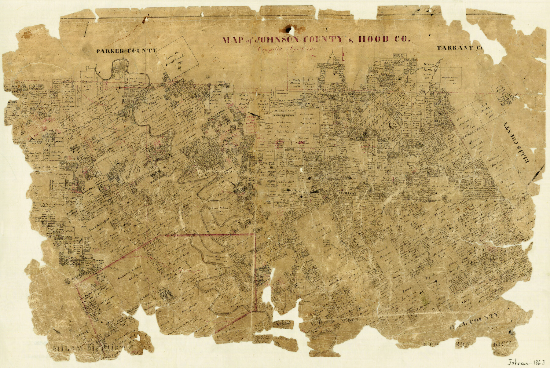
Map of Johnson County & Hood County
-
Map/Doc
3735
-
Collection
General Map Collection
-
Object Dates
4/1863 (Creation Date)
-
Counties
Johnson Hood
-
Subjects
County
-
Height x Width
19.3 x 28.3 inches
49.0 x 71.9 cm
-
Features
Squaw Creek
Caddo Peak
Aquila Creek
Bush Creek
Paloxy Creek
Georges Creek
Comanche Peak
Fall Creek
Strouds Creek
Mitchell's Creek
Buck Creek
Bony Creek
Aperson Creek
Gifford's Peak
Willow Creek
Cleburne
Buffalo Creek
Buchanan
Rock Creek
Caddo Creek
Deer Creek
Mustang Creek
Long Creek
Robinson's Creek
Part of: General Map Collection
Montague County Rolled Sketch 4

Print $20.00
- Digital $50.00
Montague County Rolled Sketch 4
1940
Size 37.8 x 20.5 inches
Map/Doc 6788
Hutchinson County Rolled Sketch 18

Print $20.00
- Digital $50.00
Hutchinson County Rolled Sketch 18
Size 30.4 x 32.6 inches
Map/Doc 9244
Right of Way & Track Map, San Antonio & Aransas Pass Railway Co.

Print $40.00
- Digital $50.00
Right of Way & Track Map, San Antonio & Aransas Pass Railway Co.
1919
Size 25.3 x 56.4 inches
Map/Doc 64217
Reeves County Sketch File 26

Print $4.00
- Digital $50.00
Reeves County Sketch File 26
1964
Size 4.1 x 8.8 inches
Map/Doc 35226
Starr County Sketch File 17

Print $24.00
- Digital $50.00
Starr County Sketch File 17
1880
Size 12.8 x 8.2 inches
Map/Doc 36874
Jefferson County Boundary File 1

Print $10.00
- Digital $50.00
Jefferson County Boundary File 1
Size 9.8 x 6.7 inches
Map/Doc 55514
Hudspeth County Working Sketch 4

Print $20.00
- Digital $50.00
Hudspeth County Working Sketch 4
1914
Size 16.9 x 20.5 inches
Map/Doc 66285
Callahan County Working Sketch 6

Print $20.00
- Digital $50.00
Callahan County Working Sketch 6
1955
Size 30.2 x 18.8 inches
Map/Doc 67888
Kendall County Working Sketch 27

Print $20.00
- Digital $50.00
Kendall County Working Sketch 27
1994
Size 25.0 x 37.5 inches
Map/Doc 66700
Panola County Working Sketch 32

Print $20.00
- Digital $50.00
Panola County Working Sketch 32
1982
Map/Doc 71441
Hudspeth County Sketch File 7

Print $6.00
- Digital $50.00
Hudspeth County Sketch File 7
1900
Size 14.2 x 8.7 inches
Map/Doc 26892
Briscoe County Rolled Sketch 14

Print $40.00
- Digital $50.00
Briscoe County Rolled Sketch 14
1913
Size 36.0 x 48.9 inches
Map/Doc 8529
You may also like
Galveston County Working Sketch 3

Print $20.00
- Digital $50.00
Galveston County Working Sketch 3
1915
Size 21.4 x 19.5 inches
Map/Doc 69340
Swisher County Working Sketch 3

Print $20.00
- Digital $50.00
Swisher County Working Sketch 3
1951
Size 22.9 x 23.4 inches
Map/Doc 62414
Crockett County Working Sketch 7

Print $20.00
- Digital $50.00
Crockett County Working Sketch 7
1891
Size 18.4 x 21.7 inches
Map/Doc 68340
Colorado River, Brackenridge Tract

Print $20.00
- Digital $50.00
Colorado River, Brackenridge Tract
1927
Size 43.6 x 32.1 inches
Map/Doc 65325
Flight Mission No. CON-4R, Frame 143, Stonewall County

Print $20.00
- Digital $50.00
Flight Mission No. CON-4R, Frame 143, Stonewall County
1957
Size 18.3 x 22.0 inches
Map/Doc 86993
[Liberty County, Texas]
![60297, [Liberty County, Texas], General Map Collection](https://historictexasmaps.com/wmedia_w700/maps/60297-1.tif.jpg)
Print $20.00
- Digital $50.00
[Liberty County, Texas]
1890
Size 24.2 x 16.9 inches
Map/Doc 60297
[State Capitol Leagues and County School Leagues]
![92475, [State Capitol Leagues and County School Leagues], Twichell Survey Records](https://historictexasmaps.com/wmedia_w700/maps/92475-1.tif.jpg)
Print $20.00
- Digital $50.00
[State Capitol Leagues and County School Leagues]
Size 19.4 x 11.8 inches
Map/Doc 92475
The Republic County of Travis. Created, January 25, 1840

Print $20.00
The Republic County of Travis. Created, January 25, 1840
2020
Size 20.8 x 21.6 inches
Map/Doc 96289
[Sketch showing details along East line of Lipscomb County]
![89939, [Sketch showing details along East line of Lipscomb County], Twichell Survey Records](https://historictexasmaps.com/wmedia_w700/maps/89939-1.tif.jpg)
Print $40.00
- Digital $50.00
[Sketch showing details along East line of Lipscomb County]
Size 15.4 x 66.7 inches
Map/Doc 89939
Plat Proposed Location of Highway From Plains to Intersect Lovington Highway on New Mexico State Line

Print $20.00
- Digital $50.00
Plat Proposed Location of Highway From Plains to Intersect Lovington Highway on New Mexico State Line
Size 44.2 x 17.3 inches
Map/Doc 92856
[Hidalgo County]
![89517, [Hidalgo County], Barnes Railroad Collection](https://historictexasmaps.com/wmedia_w700/maps/89517.tif.jpg)
Print $20.00
- Digital $50.00
[Hidalgo County]
Size 44.7 x 26.0 inches
Map/Doc 89517
Smith County Working Sketch 12

Print $20.00
- Digital $50.00
Smith County Working Sketch 12
1961
Size 30.3 x 30.6 inches
Map/Doc 63897