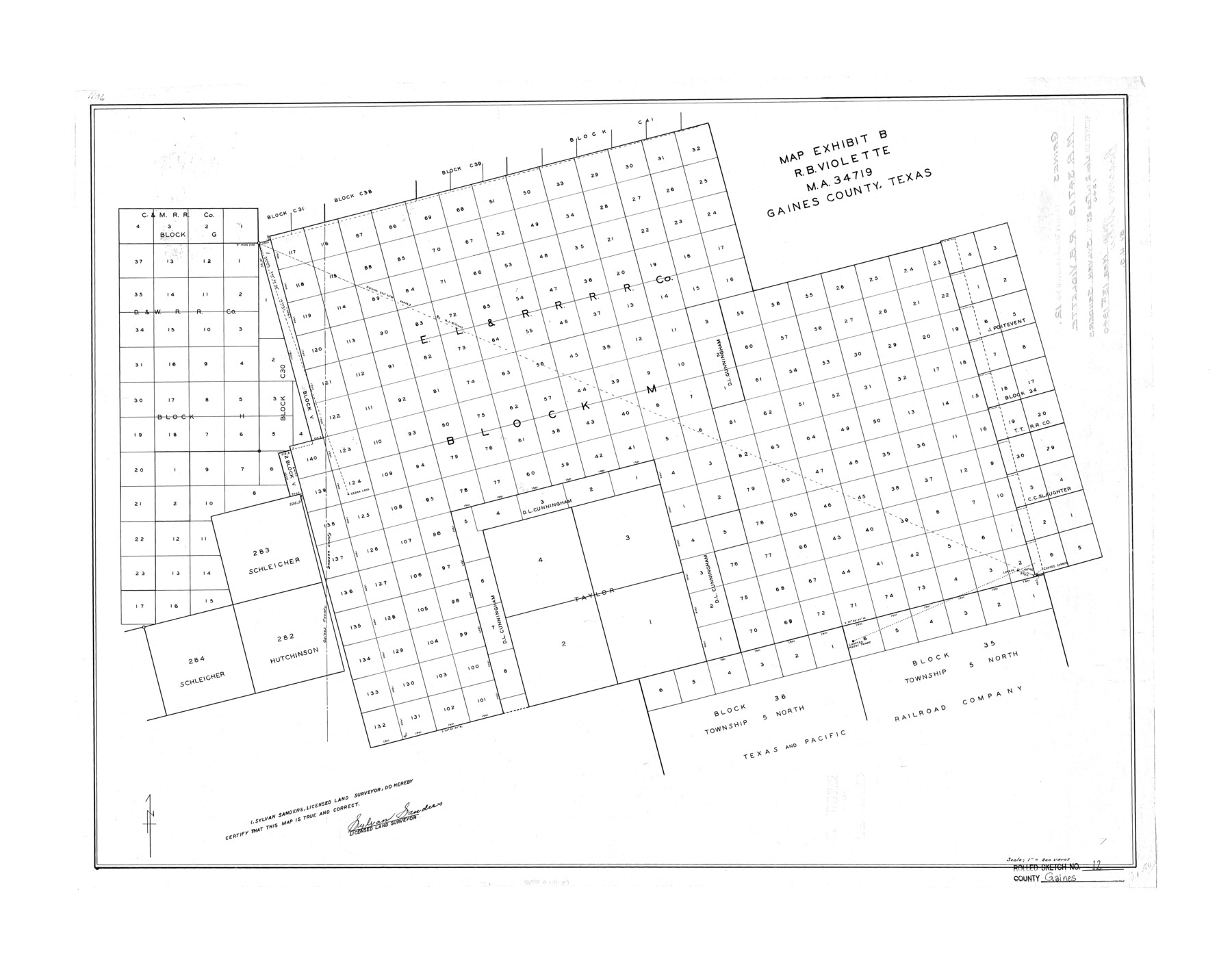
Gaines County Rolled Sketch 12
Map Exhibit B, R.B. Violette, MA 34719, Gaines County, Texas
-
Map/Doc
5932
-
Collection
General Map Collection
-
Object Dates
1940/2/23 (Creation Date)
1940/3/13 (File Date)
-
People and Organizations
Sylvan Sanders (Surveyor/Engineer)
-
Counties
Gaines Dawson
-
Subjects
Surveying Rolled Sketch
-
Height x Width
26.6 x 33.8 inches
67.6 x 85.9 cm
-
Scale
1" = 200 varas
Part of: General Map Collection
Montgomery County Working Sketch 25

Print $40.00
- Digital $50.00
Montgomery County Working Sketch 25
1941
Size 50.0 x 43.7 inches
Map/Doc 71132
No. 2 Chart of Corpus Christi Pass, Texas

Print $20.00
- Digital $50.00
No. 2 Chart of Corpus Christi Pass, Texas
1878
Size 18.3 x 27.3 inches
Map/Doc 73021
Deaf Smith County Sketch File 1 1/2

Print $20.00
- Digital $50.00
Deaf Smith County Sketch File 1 1/2
Size 20.7 x 17.1 inches
Map/Doc 11302
Duval County Boundary File 4

Print $40.00
- Digital $50.00
Duval County Boundary File 4
Size 39.5 x 13.7 inches
Map/Doc 52767
Lynn County Sketch File 19

Print $36.00
- Digital $50.00
Lynn County Sketch File 19
Size 11.2 x 8.7 inches
Map/Doc 30519
Flight Mission No. BQR-4K, Frame 63, Brazoria County

Print $20.00
- Digital $50.00
Flight Mission No. BQR-4K, Frame 63, Brazoria County
1952
Size 18.9 x 22.5 inches
Map/Doc 83996
Flight Mission No. BRA-7M, Frame 6, Jefferson County

Print $20.00
- Digital $50.00
Flight Mission No. BRA-7M, Frame 6, Jefferson County
1953
Size 18.5 x 22.3 inches
Map/Doc 85457
Van Zandt County Rolled Sketch 6

Print $3.00
- Digital $50.00
Van Zandt County Rolled Sketch 6
1946
Size 9.3 x 11.3 inches
Map/Doc 10311
Map of Jasper County

Print $20.00
- Digital $50.00
Map of Jasper County
1839
Size 41.6 x 28.5 inches
Map/Doc 3711
Bosque County Sketch File 2

Print $4.00
- Digital $50.00
Bosque County Sketch File 2
1847
Size 7.8 x 12.4 inches
Map/Doc 14740
Montgomery County Sketch File 2a

Print $4.00
- Digital $50.00
Montgomery County Sketch File 2a
1849
Size 8.0 x 12.3 inches
Map/Doc 31768
Map of Ochiltree County, Texas

Print $20.00
- Digital $50.00
Map of Ochiltree County, Texas
Size 17.9 x 14.6 inches
Map/Doc 4610
You may also like
Flight Mission No. CGI-1N, Frame 139, Cameron County

Print $20.00
- Digital $50.00
Flight Mission No. CGI-1N, Frame 139, Cameron County
1955
Size 18.6 x 22.2 inches
Map/Doc 84495
Travels to the source of the Missouri River and across the American Continent to the Pacific Ocean - Vol. 2

Travels to the source of the Missouri River and across the American Continent to the Pacific Ocean - Vol. 2
1815
Map/Doc 97413
Parker County Sketch File C

Print $4.00
- Digital $50.00
Parker County Sketch File C
1857
Size 6.1 x 7.8 inches
Map/Doc 33512
H No. 2 - Preliminary Sketch of Mobile Bay

Print $20.00
- Digital $50.00
H No. 2 - Preliminary Sketch of Mobile Bay
1852
Size 19.4 x 15.2 inches
Map/Doc 97223
Archer County Sketch File 20

Print $6.00
- Digital $50.00
Archer County Sketch File 20
1936
Size 11.0 x 8.7 inches
Map/Doc 13655
Lake Austin, Travis County, Texas

Print $20.00
- Digital $50.00
Lake Austin, Travis County, Texas
1937
Size 24.8 x 16.4 inches
Map/Doc 2056
Val Verde County Working Sketch 57

Print $20.00
- Digital $50.00
Val Verde County Working Sketch 57
1958
Size 29.2 x 31.0 inches
Map/Doc 72192
Bush-Hills-Addition, Subdivision of Section 9, Block 11 for W. H. Bush, Esq. Chicago

Print $20.00
- Digital $50.00
Bush-Hills-Addition, Subdivision of Section 9, Block 11 for W. H. Bush, Esq. Chicago
Size 19.1 x 16.1 inches
Map/Doc 92110
Flight Mission No. CRK-3P, Frame 125, Refugio County

Print $20.00
- Digital $50.00
Flight Mission No. CRK-3P, Frame 125, Refugio County
1956
Size 18.5 x 22.5 inches
Map/Doc 86913
Flight Mission No. BRA-7M, Frame 144, Jefferson County

Print $20.00
- Digital $50.00
Flight Mission No. BRA-7M, Frame 144, Jefferson County
1953
Size 18.5 x 22.3 inches
Map/Doc 85538
Montgomery County Sketch File 26

Print $6.00
- Digital $50.00
Montgomery County Sketch File 26
1845
Size 13.4 x 11.4 inches
Map/Doc 31871
Robertson County Working Sketch 3

Print $20.00
- Digital $50.00
Robertson County Working Sketch 3
1969
Size 36.5 x 30.8 inches
Map/Doc 63576