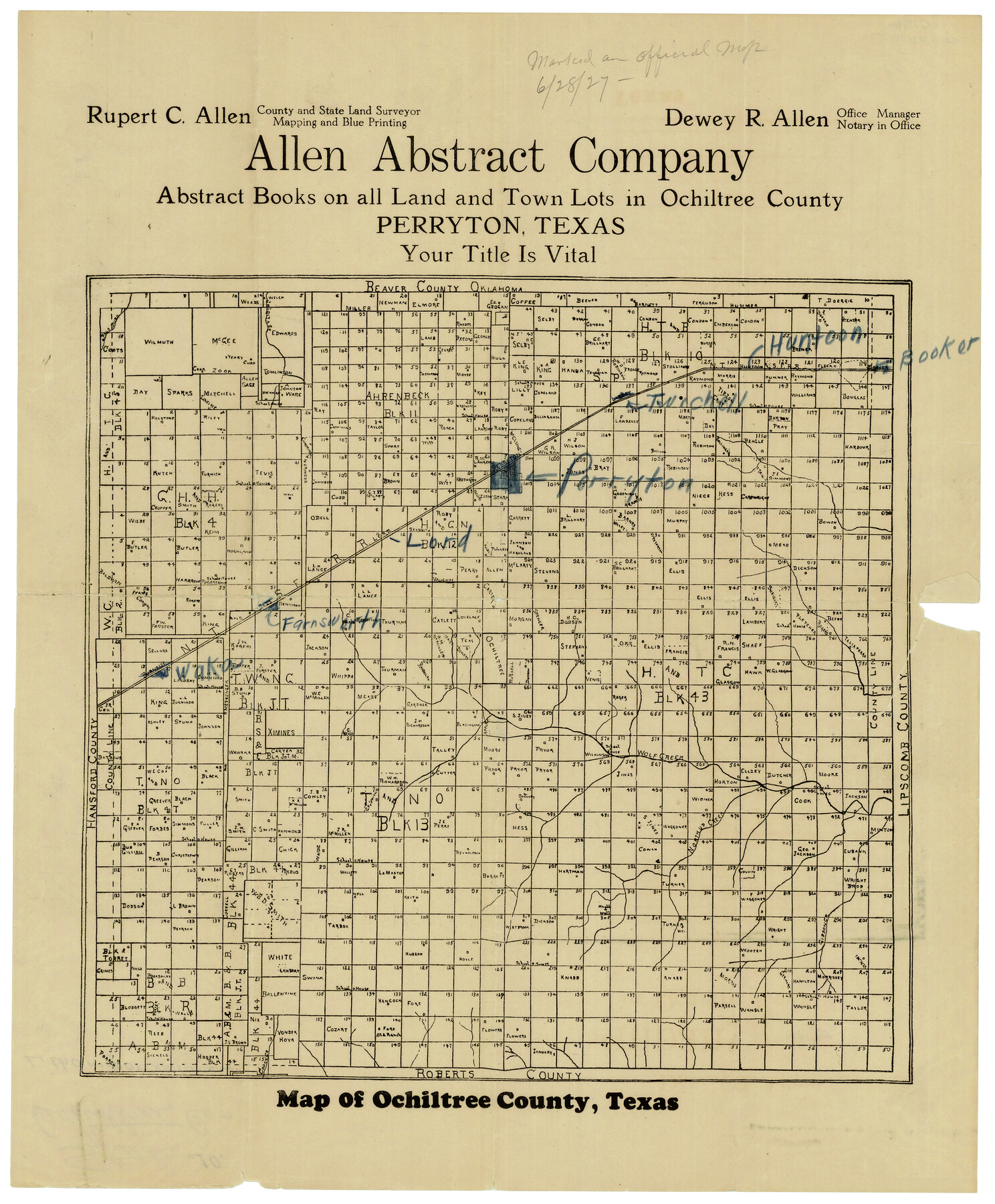
Map of Ochiltree County, Texas
Ochiltree County Sketch File 10
-
Map/Doc
4610
-
Collection
General Map Collection
-
People and Organizations
Allen Abstract Company, Perryton (Publisher)
Rupert C. Allen (Surveyor/Engineer)
-
Counties
Ochiltree
-
Subjects
County
-
Height x Width
17.9 x 14.6 inches
45.5 x 37.1 cm
Part of: General Map Collection
Val Verde County Sketch File Z21

Print $20.00
- Digital $50.00
Val Verde County Sketch File Z21
Size 18.3 x 17.3 inches
Map/Doc 12560
Donley County Working Sketch 2

Print $20.00
- Digital $50.00
Donley County Working Sketch 2
1916
Size 15.2 x 17.1 inches
Map/Doc 68735
Andrews County Sketch File 1

Print $6.00
- Digital $50.00
Andrews County Sketch File 1
Size 9.0 x 13.6 inches
Map/Doc 12818

Flight Mission No. DQN-1K, Frame 69, Calhoun County

Print $20.00
- Digital $50.00
Flight Mission No. DQN-1K, Frame 69, Calhoun County
1953
Size 18.5 x 22.2 inches
Map/Doc 84156
Flight Mission No. DQO-8K, Frame 75, Galveston County

Print $20.00
- Digital $50.00
Flight Mission No. DQO-8K, Frame 75, Galveston County
1952
Size 18.7 x 22.5 inches
Map/Doc 85179
Milam County Working Sketch 9

Print $20.00
- Digital $50.00
Milam County Working Sketch 9
1976
Size 27.2 x 22.7 inches
Map/Doc 71024
The American Military Pocket Atlas; being an approved Collection of Correct Maps, both general and particular, of the British Colonies; Especially those which now are, or probably may be the Theatre of War

The American Military Pocket Atlas; being an approved Collection of Correct Maps, both general and particular, of the British Colonies; Especially those which now are, or probably may be the Theatre of War
1776
Map/Doc 97398
Live Oak County Rolled Sketch 3

Print $20.00
- Digital $50.00
Live Oak County Rolled Sketch 3
1944
Size 31.2 x 47.2 inches
Map/Doc 10630
Gulf of Mexico

Print $20.00
- Digital $50.00
Gulf of Mexico
1900
Size 18.3 x 28.1 inches
Map/Doc 72650
Cooke County Working Sketch 9

Print $20.00
- Digital $50.00
Cooke County Working Sketch 9
1940
Size 40.6 x 27.9 inches
Map/Doc 68246
Map of the State of Texas Showing Original Land Districts

Print $20.00
- Digital $50.00
Map of the State of Texas Showing Original Land Districts
1891
Size 42.2 x 42.4 inches
Map/Doc 2138
You may also like
Gillespie County Sketch File 12

Print $4.00
- Digital $50.00
Gillespie County Sketch File 12
1877
Size 9.6 x 6.3 inches
Map/Doc 24151
Pecos County Sketch File 94

Print $20.00
- Digital $50.00
Pecos County Sketch File 94
1956
Size 25.8 x 17.3 inches
Map/Doc 12185
[Right of Way & Track Map, The Texas & Pacific Ry. Co. Main Line]
![64660, [Right of Way & Track Map, The Texas & Pacific Ry. Co. Main Line], General Map Collection](https://historictexasmaps.com/wmedia_w700/maps/64660.tif.jpg)
Print $20.00
- Digital $50.00
[Right of Way & Track Map, The Texas & Pacific Ry. Co. Main Line]
Size 11.0 x 18.6 inches
Map/Doc 64660
Flight Mission No. BRE-2P, Frame 18, Nueces County

Print $20.00
- Digital $50.00
Flight Mission No. BRE-2P, Frame 18, Nueces County
1956
Size 18.5 x 22.7 inches
Map/Doc 86727
Texas Intracoastal Waterway, Aransas Bay to Aransas Pass

Print $20.00
- Digital $50.00
Texas Intracoastal Waterway, Aransas Bay to Aransas Pass
1957
Size 27.5 x 39.1 inches
Map/Doc 73436
Navigation Maps of Gulf Intracoastal Waterway, Port Arthur to Brownsville, Texas

Print $4.00
- Digital $50.00
Navigation Maps of Gulf Intracoastal Waterway, Port Arthur to Brownsville, Texas
1951
Size 16.7 x 21.5 inches
Map/Doc 65434
Hunt County Sketch File 4

Print $4.00
- Digital $50.00
Hunt County Sketch File 4
1852
Size 12.1 x 7.7 inches
Map/Doc 27087
[Surveys in the Liberty District in Tyler and Polk Counties]
![331, [Surveys in the Liberty District in Tyler and Polk Counties], General Map Collection](https://historictexasmaps.com/wmedia_w700/maps/331.tif.jpg)
Print $2.00
- Digital $50.00
[Surveys in the Liberty District in Tyler and Polk Counties]
1847
Size 5.9 x 8.4 inches
Map/Doc 331
Flight Mission No. CUG-1P, Frame 75, Kleberg County

Print $20.00
- Digital $50.00
Flight Mission No. CUG-1P, Frame 75, Kleberg County
1956
Size 18.5 x 22.3 inches
Map/Doc 86140
Lynn County Rolled Sketch H

Print $20.00
- Digital $50.00
Lynn County Rolled Sketch H
1902
Size 43.6 x 38.4 inches
Map/Doc 9472
Shelby County Working Sketch 31a

Print $40.00
- Digital $50.00
Shelby County Working Sketch 31a
2003
Size 32.6 x 70.2 inches
Map/Doc 78643
San Saba County Rolled Sketch 1

Print $3.00
- Digital $50.00
San Saba County Rolled Sketch 1
Size 11.7 x 9.0 inches
Map/Doc 7742