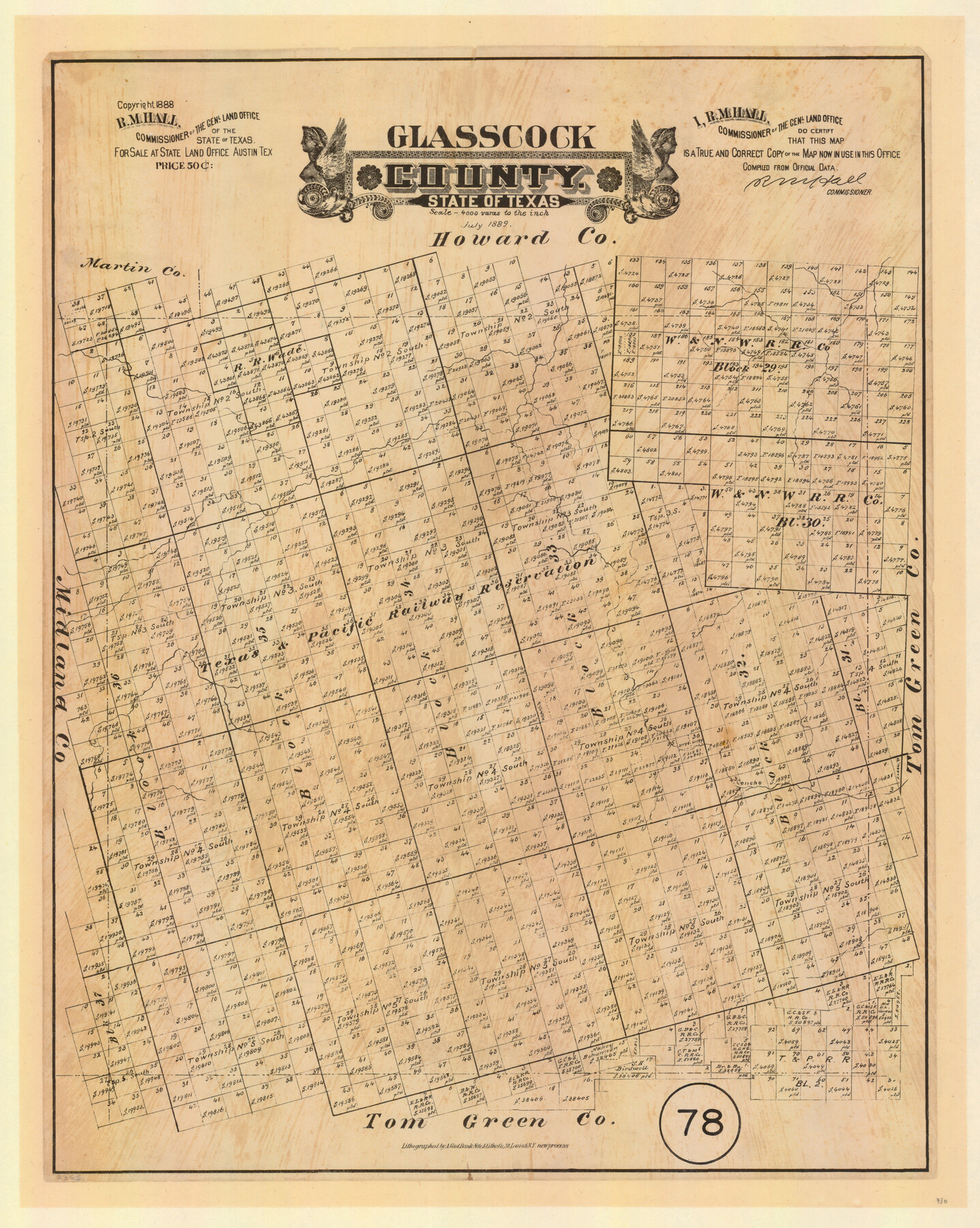
Glasscock County, Texas
-
Map/Doc
730
-
Collection
Maddox Collection
-
Object Dates
7/1889 (Creation Date)
-
People and Organizations
General Land Office (Publisher)
August Gast & Co. (Lithographer)
-
Counties
Glasscock
-
Subjects
County
-
Height x Width
21.7 x 18.1 inches
55.1 x 46.0 cm
-
Medium
paper, etching/engraving/lithograph
-
Scale
1" = 4000 varas
-
Comments
Conservation funded in 2011.
-
Features
Concho River
Part of: Maddox Collection
Revised Sectional Map No. 6 showing land surveys in parts of Presidio and Brewster Counties, Texas

Print $20.00
- Digital $50.00
Revised Sectional Map No. 6 showing land surveys in parts of Presidio and Brewster Counties, Texas
Size 24.2 x 23.0 inches
Map/Doc 4475
Map of Falls County, Texas

Print $20.00
- Digital $50.00
Map of Falls County, Texas
1879
Size 19.4 x 23.0 inches
Map/Doc 724
Sketch in Atascosa County

Print $3.00
- Digital $50.00
Sketch in Atascosa County
1890
Size 12.6 x 11.4 inches
Map/Doc 578
[McK. & Williams No. 601 and surrounding surveys, Travis County]
![75553, [McK. & Williams No. 601 and surrounding surveys, Travis County], Maddox Collection](https://historictexasmaps.com/wmedia_w700/maps/75553.tif.jpg)
Print $3.00
- Digital $50.00
[McK. & Williams No. 601 and surrounding surveys, Travis County]
Size 16.3 x 10.7 inches
Map/Doc 75553
Map of part of Presidio Co. Texas

Print $20.00
- Digital $50.00
Map of part of Presidio Co. Texas
Size 16.5 x 21.3 inches
Map/Doc 75769
[Santa Rosa Leagues, Brooks & Kenedy Counties, Texas]
![10774, [Santa Rosa Leagues, Brooks & Kenedy Counties, Texas], Maddox Collection](https://historictexasmaps.com/wmedia_w700/maps/10774.tif.jpg)
Print $20.00
- Digital $50.00
[Santa Rosa Leagues, Brooks & Kenedy Counties, Texas]
Size 21.0 x 24.6 inches
Map/Doc 10774
Bell County, Texas

Print $20.00
- Digital $50.00
Bell County, Texas
1879
Size 23.7 x 29.0 inches
Map/Doc 516
Sketch showing position of Asylum Lands Blk. 4, H. & T. C. R.R. Co. & river surveys on north side of Middle Concho, Tom Green Co.

Print $20.00
- Digital $50.00
Sketch showing position of Asylum Lands Blk. 4, H. & T. C. R.R. Co. & river surveys on north side of Middle Concho, Tom Green Co.
Size 14.4 x 20.6 inches
Map/Doc 388
P.J. Lawless Addition of Part of Outlots 29 and 30, Division D, Austin, Texas.

Print $20.00
- Digital $50.00
P.J. Lawless Addition of Part of Outlots 29 and 30, Division D, Austin, Texas.
1916
Size 13.6 x 16.6 inches
Map/Doc 502
Map of Lands Belonging to the Austin & Northern Land & Cattle Co., Coke Co., Texas

Print $20.00
- Digital $50.00
Map of Lands Belonging to the Austin & Northern Land & Cattle Co., Coke Co., Texas
Size 23.5 x 19.0 inches
Map/Doc 379
Dawson County, Texas

Print $20.00
- Digital $50.00
Dawson County, Texas
1880
Size 28.6 x 20.5 inches
Map/Doc 705
[Sketch of Sullivan Property]
![75775, [Sketch of Sullivan Property], Maddox Collection](https://historictexasmaps.com/wmedia_w700/maps/75775.tif.jpg)
Print $20.00
- Digital $50.00
[Sketch of Sullivan Property]
Size 14.3 x 22.7 inches
Map/Doc 75775
You may also like
Eastland County Rolled Sketch 19

Print $20.00
- Digital $50.00
Eastland County Rolled Sketch 19
1980
Size 28.9 x 30.9 inches
Map/Doc 8825
Dallas County Sketch File 1

Print $4.00
- Digital $50.00
Dallas County Sketch File 1
1853
Size 7.2 x 7.0 inches
Map/Doc 20394
Leon County Working Sketch 46

Print $20.00
- Digital $50.00
Leon County Working Sketch 46
1980
Size 41.5 x 27.1 inches
Map/Doc 70445
Map of Ellis County

Print $20.00
- Digital $50.00
Map of Ellis County
1889
Size 38.9 x 47.7 inches
Map/Doc 4941
Upton County Rolled Sketch 41

Print $20.00
- Digital $50.00
Upton County Rolled Sketch 41
Size 27.4 x 40.8 inches
Map/Doc 8080
Flight Mission No. CRC-1R, Frame 96, Chambers County

Print $20.00
- Digital $50.00
Flight Mission No. CRC-1R, Frame 96, Chambers County
1956
Size 18.6 x 22.3 inches
Map/Doc 84711
Freestone County Boundary File 1

Print $6.00
- Digital $50.00
Freestone County Boundary File 1
Size 14.2 x 8.8 inches
Map/Doc 53585
Hays County Sketch File 7

Print $4.00
- Digital $50.00
Hays County Sketch File 7
1858
Size 8.4 x 12.9 inches
Map/Doc 26208
The Land Offices. No. 11, Victoria, December 22, 1836

Print $20.00
The Land Offices. No. 11, Victoria, December 22, 1836
2020
Size 21.8 x 21.7 inches
Map/Doc 96424
Haskell County Sketch File 1

Print $20.00
- Digital $50.00
Haskell County Sketch File 1
1856
Size 19.9 x 10.6 inches
Map/Doc 11738
Mills County Sketch File 25

Print $8.00
- Digital $50.00
Mills County Sketch File 25
1949
Size 11.3 x 8.8 inches
Map/Doc 31674
Atascosa County Sketch File 24

Print $40.00
- Digital $50.00
Atascosa County Sketch File 24
Size 17.3 x 21.5 inches
Map/Doc 10861