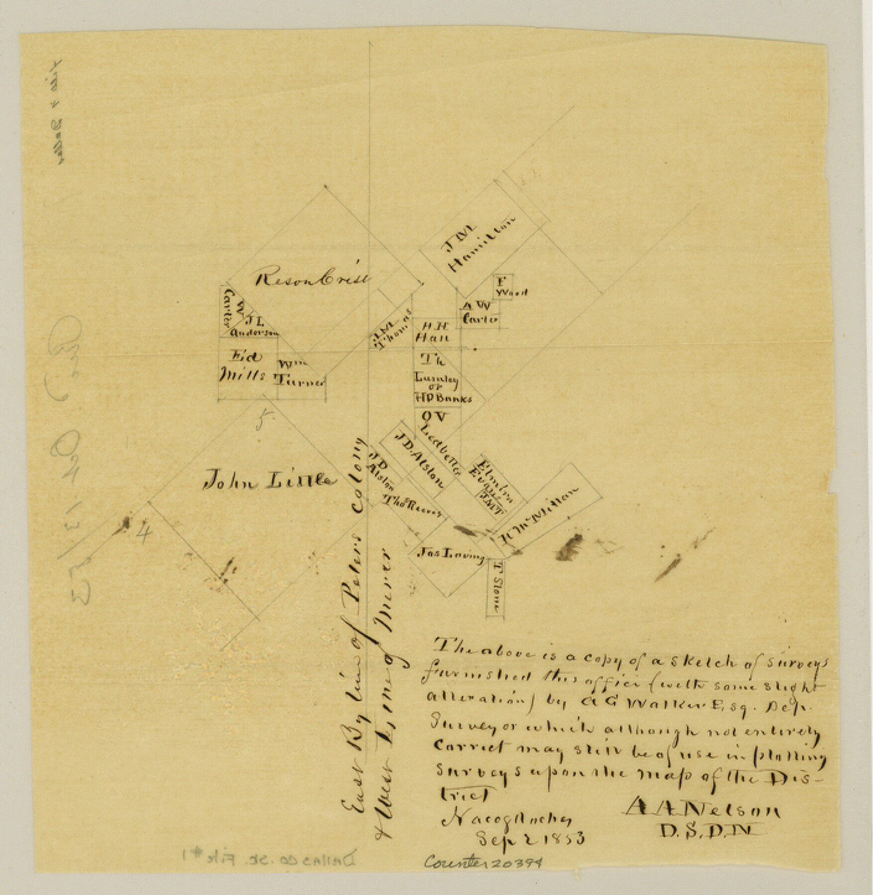
Dallas County Sketch File 1
[Sketch of surveys lying east of John Little survey]
-
Map/Doc
20394
-
Collection
General Map Collection
-
Object Dates
1853/9/2 (Creation Date)
1853/10/13 (File Date)
-
People and Organizations
A.A. Nelson (Surveyor/Engineer)
A.G. Walker (Surveyor/Engineer)
-
Counties
Dallas Rockwall
-
Subjects
Surveying Sketch File
-
Height x Width
7.2 x 7.0 inches
18.3 x 17.8 cm
-
Medium
paper, manuscript
Part of: General Map Collection
Aransas County Working Sketch 3

Print $20.00
- Digital $50.00
Aransas County Working Sketch 3
1928
Size 20.6 x 32.9 inches
Map/Doc 67170
City of Austin, Texas - Height and Area adopted by City Council

Print $20.00
- Digital $50.00
City of Austin, Texas - Height and Area adopted by City Council
Size 42.5 x 28.6 inches
Map/Doc 95712
Dickens County Working Sketch 6

Print $20.00
- Digital $50.00
Dickens County Working Sketch 6
1932
Size 23.7 x 30.7 inches
Map/Doc 68654
Milam County Boundary File 6b

Print $40.00
- Digital $50.00
Milam County Boundary File 6b
Size 31.1 x 48.8 inches
Map/Doc 57249
Gregg County Rolled Sketch RG

Print $20.00
- Digital $50.00
Gregg County Rolled Sketch RG
Size 44.4 x 36.0 inches
Map/Doc 9025
Coke County Sketch File 4

Print $46.00
- Digital $50.00
Coke County Sketch File 4
1884
Size 9.2 x 7.7 inches
Map/Doc 18566
Ward County Rolled Sketch 16

Print $20.00
- Digital $50.00
Ward County Rolled Sketch 16
1942
Size 30.5 x 21.7 inches
Map/Doc 8159
Montgomery County Sketch File 12

Print $2.00
- Digital $50.00
Montgomery County Sketch File 12
Size 8.1 x 3.8 inches
Map/Doc 31802
Flight Mission No. CUG-3P, Frame 12, Kleberg County

Print $20.00
- Digital $50.00
Flight Mission No. CUG-3P, Frame 12, Kleberg County
1956
Size 18.5 x 22.3 inches
Map/Doc 86222
Map of Bastrop County

Print $20.00
- Digital $50.00
Map of Bastrop County
1861
Size 26.3 x 29.0 inches
Map/Doc 3280
Red River County Sketch File 25

Print $20.00
- Digital $50.00
Red River County Sketch File 25
Size 26.0 x 38.9 inches
Map/Doc 10586
Map of Harris County

Print $40.00
- Digital $50.00
Map of Harris County
1897
Size 48.4 x 66.9 inches
Map/Doc 82068
You may also like
[Catfish Creek Survey]
![92647, [Catfish Creek Survey], Twichell Survey Records](https://historictexasmaps.com/wmedia_w700/maps/92647-1.tif.jpg)
Print $20.00
- Digital $50.00
[Catfish Creek Survey]
1916
Size 21.9 x 26.0 inches
Map/Doc 92647
Controlled Mosaic by Jack Amman Photogrammetric Engineers, Inc - Sheet 45

Print $20.00
- Digital $50.00
Controlled Mosaic by Jack Amman Photogrammetric Engineers, Inc - Sheet 45
1954
Size 20.0 x 24.0 inches
Map/Doc 83504
Karnes County Sketch File 16

Print $20.00
- Digital $50.00
Karnes County Sketch File 16
1950
Size 14.4 x 30.7 inches
Map/Doc 11905
Menard County Sketch File 12

Print $12.00
- Digital $50.00
Menard County Sketch File 12
1892
Size 11.1 x 8.2 inches
Map/Doc 31500
Flight Mission No. DAG-21K, Frame 121, Matagorda County

Print $20.00
- Digital $50.00
Flight Mission No. DAG-21K, Frame 121, Matagorda County
1952
Size 18.6 x 22.3 inches
Map/Doc 86447
Sutton County Rolled Sketch 66

Print $20.00
- Digital $50.00
Sutton County Rolled Sketch 66
Size 25.3 x 25.1 inches
Map/Doc 7901
Oldham County

Print $20.00
- Digital $50.00
Oldham County
1888
Size 19.6 x 16.5 inches
Map/Doc 93018
Andrews County Working Sketch 14

Print $40.00
- Digital $50.00
Andrews County Working Sketch 14
1957
Size 61.6 x 37.1 inches
Map/Doc 67060
Hudspeth County Rolled Sketch 66

Print $20.00
- Digital $50.00
Hudspeth County Rolled Sketch 66
1973
Size 12.1 x 19.9 inches
Map/Doc 6260
Val Verde County Working Sketch 117

Print $20.00
- Digital $50.00
Val Verde County Working Sketch 117
1993
Size 34.8 x 37.0 inches
Map/Doc 82843
[Sketch showing Blocks 1, B18 and E.L. & RR. Co. Blocks 2, 8 and 97]
![89950, [Sketch showing Blocks 1, B18 and E.L. & RR. Co. Blocks 2, 8 and 97], Twichell Survey Records](https://historictexasmaps.com/wmedia_w700/maps/89950-1.tif.jpg)
Print $40.00
- Digital $50.00
[Sketch showing Blocks 1, B18 and E.L. & RR. Co. Blocks 2, 8 and 97]
Size 55.1 x 44.9 inches
Map/Doc 89950
Map of the New England or Eastern States engraved to illustrate Mitchell's new intermediate geography

Print $20.00
- Digital $50.00
Map of the New England or Eastern States engraved to illustrate Mitchell's new intermediate geography
1885
Size 12.2 x 9.0 inches
Map/Doc 93515