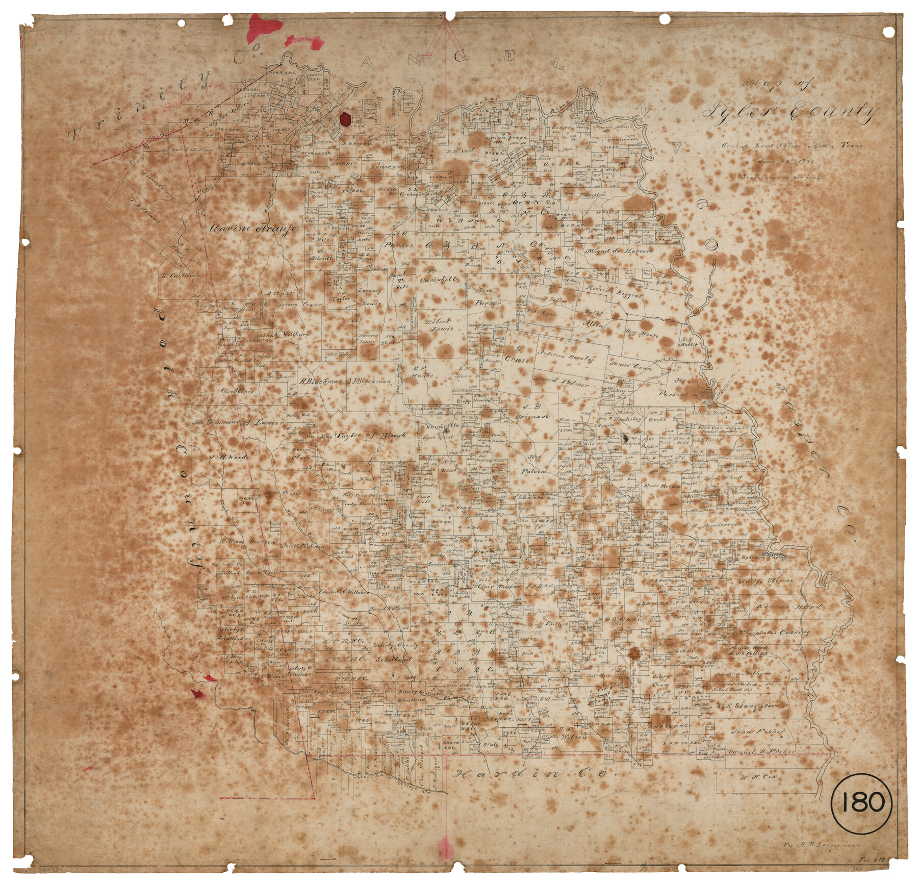
Map of Tyler County, Texas
-
Map/Doc
762
-
Collection
Maddox Collection
-
Object Dates
1881/6/23 (Creation Date)
-
People and Organizations
General Land Office (Publisher)
-
Counties
Tyler
-
Subjects
County
-
Height x Width
22.3 x 24.2 inches
56.6 x 61.5 cm
-
Medium
linen, manuscript
-
Scale
1:4000
-
Comments
Conservation funded in 2013 by Friends of the Texas General Land Office.
-
Features
Wood Creek
Village Creek
Alabama Creek
Alabama or Village Creek
Black Creek
Thouching Creek
Woodville
Turkey Creek
Otter Creek
Cypress Creek
Horse Pen Creek
Neches River
South Fork [of Rush Creek]
Rush Creek
Town Bluff
Sandys Creek
Clear Fork [of Neches River]
Billums Creek
Russel [sic] Creek
Caney Creek
McGraws Creek
Lewis Ferry
Part of: Maddox Collection
[Sketch of Surveys in Crockett County, Texas]
![10778, [Sketch of Surveys in Crockett County, Texas], Maddox Collection](https://historictexasmaps.com/wmedia_w700/maps/10778-1.tif.jpg)
Print $20.00
- Digital $50.00
[Sketch of Surveys in Crockett County, Texas]
1880
Size 12.7 x 21.3 inches
Map/Doc 10778
[Sketch of San Antonio del Encinal, Hidalgo County, Texas]
![4457, [Sketch of San Antonio del Encinal, Hidalgo County, Texas], Maddox Collection](https://historictexasmaps.com/wmedia_w700/maps/4457-1.tif.jpg)
Print $20.00
- Digital $50.00
[Sketch of San Antonio del Encinal, Hidalgo County, Texas]
Size 12.1 x 27.1 inches
Map/Doc 4457
Map of Menard County

Print $20.00
- Digital $50.00
Map of Menard County
1898
Size 19.9 x 43.1 inches
Map/Doc 5042
Map of Live Oak County, Texas

Print $20.00
- Digital $50.00
Map of Live Oak County, Texas
1911
Size 28.0 x 20.4 inches
Map/Doc 567
Map of Wilson County, Texas

Print $20.00
- Digital $50.00
Map of Wilson County, Texas
1879
Size 22.9 x 24.8 inches
Map/Doc 674
[Surveying sketch of Dan'l. Dunham, O. de Santangelo, et al in Zavala County]
![708, [Surveying sketch of Dan'l. Dunham, O. de Santangelo, et al in Zavala County], Maddox Collection](https://historictexasmaps.com/wmedia_w700/maps/0708.tif.jpg)
Print $20.00
- Digital $50.00
[Surveying sketch of Dan'l. Dunham, O. de Santangelo, et al in Zavala County]
Size 16.2 x 16.0 inches
Map/Doc 708
[Unknown Building Sketch]
![75794, [Unknown Building Sketch], Maddox Collection](https://historictexasmaps.com/wmedia_w700/maps/75794.tif.jpg)
Print $20.00
- Digital $50.00
[Unknown Building Sketch]
Size 17.1 x 22.6 inches
Map/Doc 75794
Survey of a Portion of Lot. No. 1 of Spear League

Print $20.00
- Digital $50.00
Survey of a Portion of Lot. No. 1 of Spear League
1911
Size 12.2 x 24.2 inches
Map/Doc 477
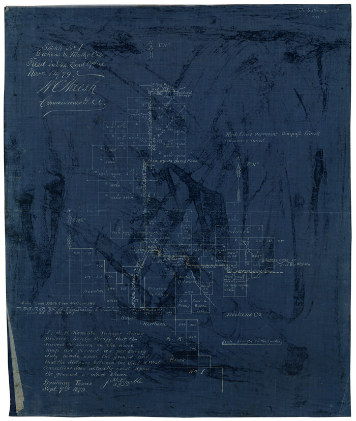
Sketch No. 1, Dickens & Motley Cos.
Print $20.00
- Digital $50.00
Sketch No. 1, Dickens & Motley Cos.
1879
Size 17.9 x 15.5 inches
Map/Doc 10761

[Sketch Showing Loma Blanca , El Tule and San Antonio de Encinal Leagues in Brooks County, Texas]
![624, [Sketch Showing Loma Blanca , El Tule and San Antonio de Encinal Leagues in Brooks County, Texas], Maddox Collection](https://historictexasmaps.com/wmedia_w700/maps/00624.tif.jpg)
Print $3.00
- Digital $50.00
[Sketch Showing Loma Blanca , El Tule and San Antonio de Encinal Leagues in Brooks County, Texas]
Size 9.3 x 14.2 inches
Map/Doc 624
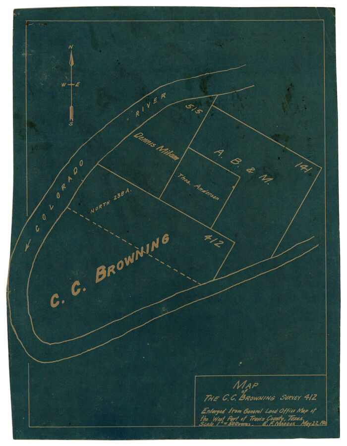
Map of the C.C. Browning survey 412 enlarged from General Land Office map of the west part of Travis County, Texas
Print $3.00
- Digital $50.00
Map of the C.C. Browning survey 412 enlarged from General Land Office map of the west part of Travis County, Texas
1920
Size 11.3 x 9.1 inches
Map/Doc 10752
You may also like
Wichita County Sketch File 7

Print $2.00
- Digital $50.00
Wichita County Sketch File 7
Size 7.5 x 13.9 inches
Map/Doc 40047
Taylor County Working Sketch 7

Print $20.00
- Digital $50.00
Taylor County Working Sketch 7
1953
Size 41.3 x 16.1 inches
Map/Doc 69617
Milam County Working Sketch 14

Print $20.00
- Digital $50.00
Milam County Working Sketch 14
1904
Size 28.2 x 16.7 inches
Map/Doc 71029
Briscoe County Rolled Sketch 11A

Print $20.00
- Digital $50.00
Briscoe County Rolled Sketch 11A
1913
Size 11.7 x 12.3 inches
Map/Doc 5329
Green & Lumsden's Ranch

Print $20.00
- Digital $50.00
Green & Lumsden's Ranch
Size 28.9 x 25.1 inches
Map/Doc 92946
Flight Mission No. CGI-3G, Frame 12, Cameron County

Print $20.00
- Digital $50.00
Flight Mission No. CGI-3G, Frame 12, Cameron County
1950
Size 19.3 x 19.0 inches
Map/Doc 84531
Aransas County Rolled Sketch 15A

Print $20.00
- Digital $50.00
Aransas County Rolled Sketch 15A
1969
Size 26.3 x 25.4 inches
Map/Doc 8411
Pecos County Sketch File 29c

Print $14.00
- Digital $50.00
Pecos County Sketch File 29c
1929
Size 11.2 x 8.8 inches
Map/Doc 33698
Burnet County Working Sketch Graphic Index

Print $20.00
- Digital $50.00
Burnet County Working Sketch Graphic Index
1924
Size 46.5 x 41.2 inches
Map/Doc 76482
Uvalde County Working Sketch 61

Print $20.00
- Digital $50.00
Uvalde County Working Sketch 61
1978
Size 40.4 x 37.4 inches
Map/Doc 72131
Galveston County NRC Article 33.136 Sketch 34

Print $20.00
- Digital $50.00
Galveston County NRC Article 33.136 Sketch 34
2005
Size 24.5 x 18.5 inches
Map/Doc 83405
Hunt County Sketch File 4a

Print $4.00
- Digital $50.00
Hunt County Sketch File 4a
1859
Size 12.6 x 8.2 inches
Map/Doc 27089