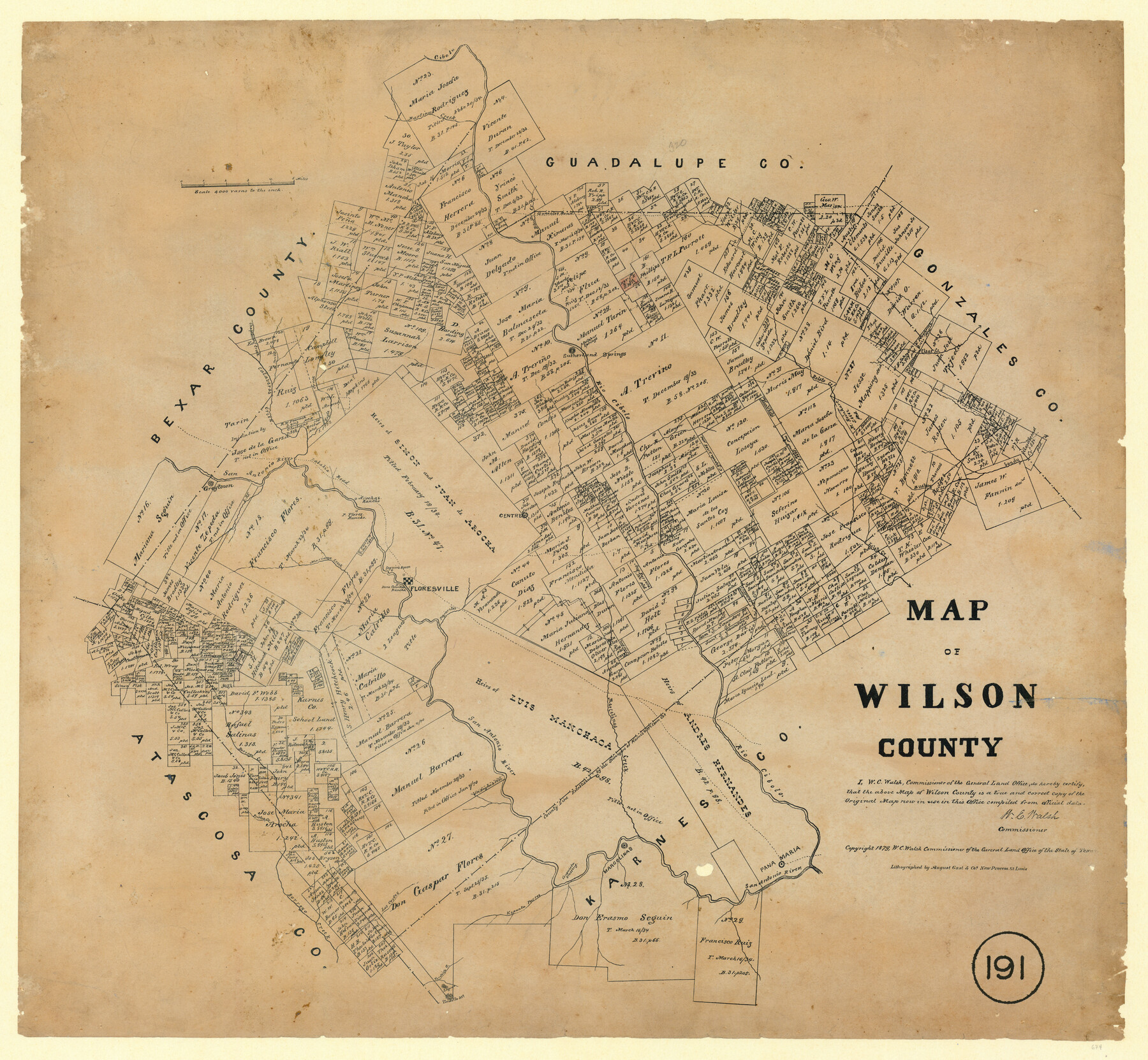
Map of Wilson County, Texas
-
Map/Doc
674
-
Collection
Maddox Collection
-
Object Dates
1879 (Creation Date)
1879 (Copyright Date)
-
People and Organizations
W.C. Walsh (GLO Commissioner)
August Gast & Co. (Lithographer)
-
Counties
Wilson
-
Subjects
County
-
Height x Width
22.9 x 24.8 inches
58.2 x 63.0 cm
-
Medium
paper, etching/engraving/lithograph
-
Scale
1" = 4000 varas
-
Comments
Conservation funded in 2010.
-
Features
Prietoe Creek
Mariana Creek
Seguin's House
Floresville
Dona Calvillas Rancho
Pajaritos
Carbajel Creek
Rocky Ford Crossing
Ecleto Creek
Borrego Creek
Greytown
Marcelinas Creek
Pana Maria
Marcelinas
Conquista Crossing
Espanta Parros Creek
Los Cortes [Creek]
Tordillo C[reek]
Tordillo Mountain
Eagle Creek
Martinez Creek
Gonzales Road
Clear Creek
Sulphur Springs
Sutherland Springs
Chapederal Creek
Parita Creek
Calaveras Creek
Cibolo River
Rio Cibolo
Ecleto Creek
Sandy Creek
Mustang Creek
Arochas Rancho
P. Flores Rancho
Labahia [sic] Road
San Antonio River
Part of: Maddox Collection
[Pitchfork Ranch]
![4480, [Pitchfork Ranch], Maddox Collection](https://historictexasmaps.com/wmedia_w700/maps/4480.tif.jpg)
Print $20.00
- Digital $50.00
[Pitchfork Ranch]
1915
Size 20.8 x 17.2 inches
Map/Doc 4480
Map of Tyler County, Texas

Print $20.00
- Digital $50.00
Map of Tyler County, Texas
1882
Size 28.3 x 21.4 inches
Map/Doc 669
Map of Grimes County, Texas

Print $20.00
- Digital $50.00
Map of Grimes County, Texas
1880
Size 29.5 x 15.6 inches
Map/Doc 432

Johnson County, Texas

Print $20.00
- Digital $50.00
Johnson County, Texas
1871
Size 18.2 x 23.3 inches
Map/Doc 734
Map of Colorado County, Texas

Print $20.00
- Digital $50.00
Map of Colorado County, Texas
Size 28.6 x 23.5 inches
Map/Doc 700
[Sketch showing Miguel Perez, Juan Jose Solis and Francisco Antonio Villareal surveys in Starr County]
![75549, [Sketch showing Miguel Perez, Juan Jose Solis and Francisco Antonio Villareal surveys in Starr County], Maddox Collection](https://historictexasmaps.com/wmedia_w700/maps/75549.tif.jpg)
Print $20.00
- Digital $50.00
[Sketch showing Miguel Perez, Juan Jose Solis and Francisco Antonio Villareal surveys in Starr County]
1914
Size 20.9 x 13.6 inches
Map/Doc 75549
Wise County, Texas

Print $20.00
- Digital $50.00
Wise County, Texas
1870
Size 20.9 x 18.0 inches
Map/Doc 767
Floyd County, Texas

Print $20.00
- Digital $50.00
Floyd County, Texas
1889
Size 24.8 x 19.2 inches
Map/Doc 626
[Blocks CD, OP and GH in Crockett, Schleicher & Sutton Counties, Texas]
![75776, [Blocks CD, OP and GH in Crockett, Schleicher & Sutton Counties, Texas], Maddox Collection](https://historictexasmaps.com/wmedia_w700/maps/75776.tif.jpg)
Print $20.00
- Digital $50.00
[Blocks CD, OP and GH in Crockett, Schleicher & Sutton Counties, Texas]
Size 22.5 x 27.5 inches
Map/Doc 75776
Map of Calhoun County, Texas

Print $20.00
- Digital $50.00
Map of Calhoun County, Texas
1879
Size 22.8 x 18.7 inches
Map/Doc 670
Map of Frio County, Texas

Print $20.00
- Digital $50.00
Map of Frio County, Texas
1879
Size 22.8 x 21.9 inches
Map/Doc 545
You may also like
Fort Bend County State Real Property Sketch 12

Print $40.00
- Digital $50.00
Fort Bend County State Real Property Sketch 12
1986
Size 43.2 x 35.0 inches
Map/Doc 61686
Reeves County Working Sketch 50

Print $20.00
- Digital $50.00
Reeves County Working Sketch 50
1974
Size 45.3 x 30.4 inches
Map/Doc 63493
Chambers County Rolled Sketch FD

Print $20.00
- Digital $50.00
Chambers County Rolled Sketch FD
1935
Size 32.7 x 26.5 inches
Map/Doc 5433
General Highway Map, El Paso County, Texas

Print $20.00
General Highway Map, El Paso County, Texas
1961
Size 18.2 x 24.6 inches
Map/Doc 79459
Sherman County Rolled Sketch 13

Print $20.00
- Digital $50.00
Sherman County Rolled Sketch 13
1951
Size 14.3 x 30.7 inches
Map/Doc 7791
Reagan County Sketch File 33

Print $4.00
- Digital $50.00
Reagan County Sketch File 33
1948
Size 8.9 x 14.4 inches
Map/Doc 35028
Potter County Working Sketch 8

Print $40.00
- Digital $50.00
Potter County Working Sketch 8
1961
Size 68.7 x 37.2 inches
Map/Doc 71668
Flight Mission No. DAG-19K, Frame 57, Matagorda County

Print $20.00
- Digital $50.00
Flight Mission No. DAG-19K, Frame 57, Matagorda County
1952
Size 18.5 x 22.3 inches
Map/Doc 86384
Harris County Rolled Sketch 41(1)

Print $13.00
- Digital $50.00
Harris County Rolled Sketch 41(1)
Size 10.0 x 15.3 inches
Map/Doc 45789
Webb County Working Sketch 66

Print $40.00
- Digital $50.00
Webb County Working Sketch 66
1966
Size 62.8 x 42.5 inches
Map/Doc 72433
Brooks County Boundary File 1a

Print $40.00
- Digital $50.00
Brooks County Boundary File 1a
Size 63.8 x 7.1 inches
Map/Doc 50836
Austin County Sketch File 10

Print $40.00
- Digital $50.00
Austin County Sketch File 10
1895
Size 25.5 x 21.0 inches
Map/Doc 10875