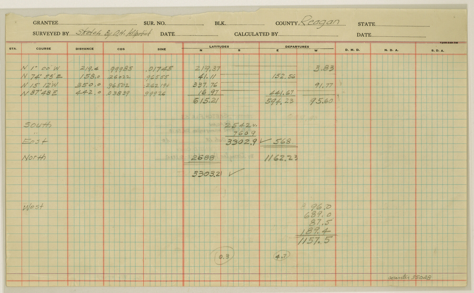
Reagan County Sketch File 33
[D.M.D. sheet]
-
Map/Doc
35028
-
Collection
General Map Collection
-
Object Dates
1948/10/9 (Creation Date)
1948/10/19 (File Date)
-
People and Organizations
O.H. Kilpatrick (Surveyor/Engineer)
-
Counties
Reagan
-
Subjects
Surveying Sketch File
-
Height x Width
8.9 x 14.4 inches
22.6 x 36.6 cm
-
Medium
paper, manuscript
-
Comments
See Reagan County Rolled Sketch 18 (7444) for sketch.
Related maps
Reagan County Rolled Sketch 18

Print $20.00
- Digital $50.00
Reagan County Rolled Sketch 18
Size 32.1 x 22.9 inches
Map/Doc 7444
Part of: General Map Collection
Val Verde County Sketch File 27

Print $40.00
- Digital $50.00
Val Verde County Sketch File 27
Size 8.7 x 19.4 inches
Map/Doc 39234
Panola County Working Sketch 14

Print $40.00
- Digital $50.00
Panola County Working Sketch 14
1945
Map/Doc 71423
Kendall County Working Sketch 28a

Print $20.00
- Digital $50.00
Kendall County Working Sketch 28a
2006
Size 29.8 x 45.0 inches
Map/Doc 83097
Outer Continental Shelf Leasing Maps (Texas Offshore Operations)

Print $20.00
- Digital $50.00
Outer Continental Shelf Leasing Maps (Texas Offshore Operations)
1954
Size 22.3 x 17.3 inches
Map/Doc 75833
Hays County Rolled Sketch 22

Print $20.00
- Digital $50.00
Hays County Rolled Sketch 22
1924
Size 19.4 x 20.6 inches
Map/Doc 6178
Flight Mission No. CRC-1R, Frame 39, Chambers County

Print $20.00
- Digital $50.00
Flight Mission No. CRC-1R, Frame 39, Chambers County
1956
Size 18.8 x 22.4 inches
Map/Doc 84707
[Tom Green County]
![82060, [Tom Green County], General Map Collection](https://historictexasmaps.com/wmedia_w700/maps/82060.tif.jpg)
Print $40.00
- Digital $50.00
[Tom Green County]
1888
Size 45.8 x 113.0 inches
Map/Doc 82060
Guadalupe County Sketch File 15d

Print $4.00
- Digital $50.00
Guadalupe County Sketch File 15d
Size 10.1 x 8.1 inches
Map/Doc 24705
Texas Coast, No. 17

Print $20.00
- Digital $50.00
Texas Coast, No. 17
Size 18.3 x 26.1 inches
Map/Doc 72713
Webb County Working Sketch 47

Print $20.00
- Digital $50.00
Webb County Working Sketch 47
1948
Size 35.9 x 36.2 inches
Map/Doc 72412
Hunt County Sketch File 32

Print $6.00
- Digital $50.00
Hunt County Sketch File 32
Size 7.9 x 11.6 inches
Map/Doc 27138
McCulloch County Sketch File 15, 15a, 15b

Print $34.00
- Digital $50.00
McCulloch County Sketch File 15, 15a, 15b
1993
Size 11.2 x 8.8 inches
Map/Doc 31207
You may also like
Map of Bandera County, Texas

Print $20.00
- Digital $50.00
Map of Bandera County, Texas
1879
Size 19.6 x 32.6 inches
Map/Doc 691
Hale County Working Sketch 2

Print $20.00
- Digital $50.00
Hale County Working Sketch 2
1916
Size 13.5 x 13.1 inches
Map/Doc 63322
Orange County Sketch File 23

Print $36.00
- Digital $50.00
Orange County Sketch File 23
1911
Size 9.2 x 5.9 inches
Map/Doc 33344
General Highway Map, Haskell County, Texas

Print $20.00
General Highway Map, Haskell County, Texas
1961
Size 18.1 x 24.7 inches
Map/Doc 79512
Brewster County Sketch File N-30

Print $6.00
- Digital $50.00
Brewster County Sketch File N-30
1969
Size 11.2 x 8.9 inches
Map/Doc 15708
Fisher County

Print $20.00
- Digital $50.00
Fisher County
1880
Size 29.4 x 25.3 inches
Map/Doc 75772
Flight Mission No. DQN-2K, Frame 123, Calhoun County

Print $20.00
- Digital $50.00
Flight Mission No. DQN-2K, Frame 123, Calhoun County
1953
Size 16.6 x 16.5 inches
Map/Doc 84299
General Highway Map, Moore County, Texas

Print $20.00
General Highway Map, Moore County, Texas
1940
Size 18.4 x 24.8 inches
Map/Doc 79203
Jack County Working Sketch 20

Print $20.00
- Digital $50.00
Jack County Working Sketch 20
1991
Size 35.4 x 28.9 inches
Map/Doc 66446

Ochiltree County Working Sketch 7

Print $40.00
- Digital $50.00
Ochiltree County Working Sketch 7
1968
Size 26.8 x 56.6 inches
Map/Doc 71320
Baylor County Sketch File 31

Print $6.00
- Digital $50.00
Baylor County Sketch File 31
1880
Size 14.3 x 8.9 inches
Map/Doc 14235