Reagan County Rolled Sketch 18
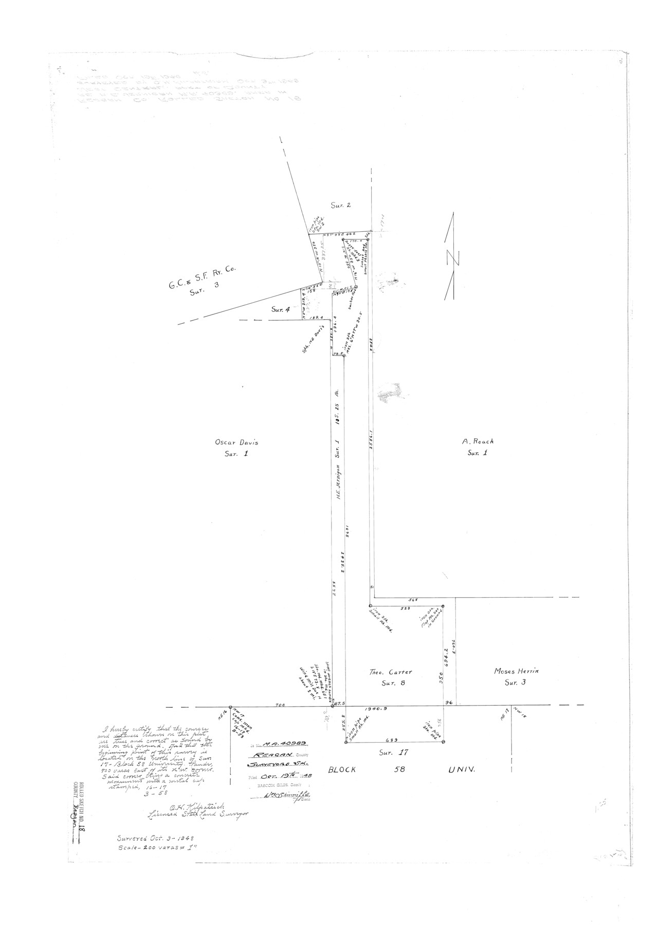
[Sketch relating to H.E. Jernigan MA-40989 and Theo. Carter sur. 8 north of sur. 17 University Lands Block 58]
-
Map/Doc
7444
-
Collection
General Map Collection
-
Object Dates
1948/10/9 (Survey Date)
1948/10/19 (File Date)
-
People and Organizations
O.H. Kilpatrick (Surveyor/Engineer)
-
Counties
Reagan
-
Subjects
Surveying Rolled Sketch
-
Height x Width
32.1 x 22.9 inches
81.5 x 58.2 cm
-
Scale
1" = 200 varas
-
Comments
See Reagan County Sketch File 33 (35028) for DMD sheet.
Related maps
Reagan County Sketch File 33

Print $4.00
- Digital $50.00
Reagan County Sketch File 33
1948
Size 8.9 x 14.4 inches
Map/Doc 35028
Part of: General Map Collection
Collingsworth County Sketch File 5

Print $20.00
- Digital $50.00
Collingsworth County Sketch File 5
1891
Size 32.0 x 24.3 inches
Map/Doc 11132
Bastrop County

Print $20.00
- Digital $50.00
Bastrop County
1872
Size 21.1 x 17.4 inches
Map/Doc 3279
Grimes County Working Sketch 18

Print $20.00
- Digital $50.00
Grimes County Working Sketch 18
1990
Size 33.1 x 42.5 inches
Map/Doc 63309
Flight Mission No. DQO-3K, Frame 79, Galveston County

Print $20.00
- Digital $50.00
Flight Mission No. DQO-3K, Frame 79, Galveston County
1952
Size 18.9 x 22.5 inches
Map/Doc 85084
Angelina County

Print $40.00
- Digital $50.00
Angelina County
1945
Size 39.0 x 48.4 inches
Map/Doc 73068
Jeff Davis County Rolled Sketch 9

Print $20.00
- Digital $50.00
Jeff Davis County Rolled Sketch 9
Size 18.3 x 22.9 inches
Map/Doc 6362
Map of the Recognised Line M. El. P. & P. R.R. from Texas & Arkansas State Line to Milam & Bexar Land District Line

Print $40.00
- Digital $50.00
Map of the Recognised Line M. El. P. & P. R.R. from Texas & Arkansas State Line to Milam & Bexar Land District Line
1856
Size 14.3 x 89.8 inches
Map/Doc 64053
Plan of Three Sitios of Land Granted to Vicente Micheli

Print $2.00
- Digital $50.00
Plan of Three Sitios of Land Granted to Vicente Micheli
Size 9.2 x 8.6 inches
Map/Doc 18
Young County Working Sketch Graphic Index

Print $20.00
- Digital $50.00
Young County Working Sketch Graphic Index
1941
Size 44.1 x 38.4 inches
Map/Doc 76748
Finder Map of Greater San Antonio

Print $20.00
- Digital $50.00
Finder Map of Greater San Antonio
1950
Size 28.7 x 21.4 inches
Map/Doc 94029
Tarrant County Boundary File 2

Print $6.00
- Digital $50.00
Tarrant County Boundary File 2
Size 14.4 x 9.0 inches
Map/Doc 59111
[Right of Way & Track Map, The Texas & Pacific Ry. Co. Main Line]
![64689, [Right of Way & Track Map, The Texas & Pacific Ry. Co. Main Line], General Map Collection](https://historictexasmaps.com/wmedia_w700/maps/64689.tif.jpg)
Print $20.00
- Digital $50.00
[Right of Way & Track Map, The Texas & Pacific Ry. Co. Main Line]
Size 11.0 x 19.0 inches
Map/Doc 64689
You may also like
Flight Mission No. BRE-2P, Frame 108, Nueces County

Print $20.00
- Digital $50.00
Flight Mission No. BRE-2P, Frame 108, Nueces County
1956
Size 18.5 x 22.5 inches
Map/Doc 86793

Montgomery County Sketch File 37

Print $6.00
- Digital $50.00
Montgomery County Sketch File 37
Size 12.6 x 8.2 inches
Map/Doc 31916
[G. B. & C. N. G. Blocks K3-K8]
![90537, [G. B. & C. N. G. Blocks K3-K8], Twichell Survey Records](https://historictexasmaps.com/wmedia_w700/maps/90537-1.tif.jpg)
Print $3.00
- Digital $50.00
[G. B. & C. N. G. Blocks K3-K8]
Size 11.4 x 13.7 inches
Map/Doc 90537
Wharton County

Print $20.00
- Digital $50.00
Wharton County
1877
Size 24.6 x 26.7 inches
Map/Doc 4133
[Surveys along the Leon River]
![82093, [Surveys along the Leon River], General Map Collection](https://historictexasmaps.com/wmedia_w700/maps/82093.tif.jpg)
Print $20.00
- Digital $50.00
[Surveys along the Leon River]
1840
Size 20.5 x 6.7 inches
Map/Doc 82093
Crockett County Working Sketch 62

Print $40.00
- Digital $50.00
Crockett County Working Sketch 62
1956
Size 121.8 x 37.1 inches
Map/Doc 68395
Red River County Working Sketch 46

Print $20.00
- Digital $50.00
Red River County Working Sketch 46
Size 34.3 x 38.9 inches
Map/Doc 72029
Map of Navarro County

Print $20.00
- Digital $50.00
Map of Navarro County
1872
Size 19.4 x 25.5 inches
Map/Doc 3910
Pecos County Rolled Sketch 103

Print $20.00
- Digital $50.00
Pecos County Rolled Sketch 103
1940
Size 27.5 x 32.4 inches
Map/Doc 7251
Intracoastal Waterway in Texas - Corpus Christi to Point Isabel including Arroyo Colorado to Mo. Pac. R.R. Bridge Near Harlingen

Print $20.00
- Digital $50.00
Intracoastal Waterway in Texas - Corpus Christi to Point Isabel including Arroyo Colorado to Mo. Pac. R.R. Bridge Near Harlingen
1933
Size 28.2 x 41.3 inches
Map/Doc 61873
El Paso County Boundary File 1

Print $48.00
- Digital $50.00
El Paso County Boundary File 1
Size 12.3 x 35.0 inches
Map/Doc 53015