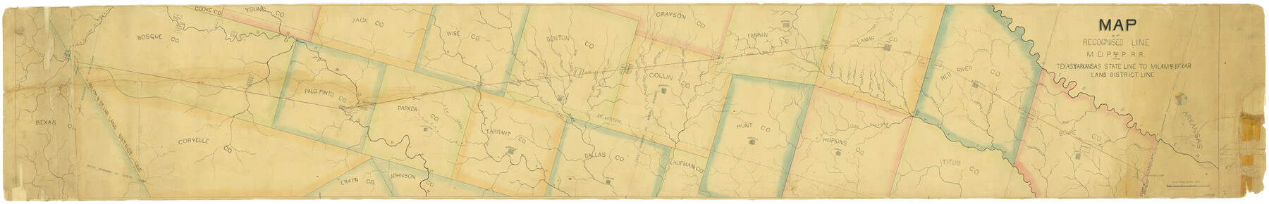
Map of the Recognised Line M. El. P. & P. R.R. from Texas & Arkansas State Line to Milam & Bexar Land District Line
Z-2-15
-
Map/Doc
64053
-
Collection
General Map Collection
-
Object Dates
1856-1857 (Creation Date)
6/20/1857 (File Date)
-
Counties
Bowie Titus Hopkins Hunt
-
Subjects
Railroads
-
Height x Width
14.3 x 89.8 inches
36.3 x 228.1 cm
-
Medium
paper, manuscript
-
Scale
1:8000
-
Features
Caddo Village
Big Mustang Creek
Clarkesville
Delaware Creek
Cuthland Creek
Kickapoo Creek
Pecan Creek
Mill Creek
Mud Creek
Andersons Creek
Red Bayou
Boston
Red River
Barkman Creek
Wards Creek
MEP&P
Ringos Ferry
Brazos River
Weatherford
Clear Fork of West Fork of Trinity River
West Fork of Trinity River
Ash Creek
Birdville
Hickory Creek
Denton Fork of Trinity River
Clear Fork of Trinity River
Alton
Clear Fork of Brazos [River]
West Fork of Brazos [River]
Phantom Hill
East Fork of Brazos [River]
South Fork of Sulphur Fork
Elm Fork of Trinity River
Whites Creek
Hurricane Creek
Owl Creek
Little Pecan Creek
McKinney
Pilot Grove Creek
Honey Creek
East Fork of Trinity River
Sister Grove Creek
Greenville
Bonham
Bois D'Arc Creek
Tarrant
Dallas
Mercello Creek
Saunders Creek
Pine Creek
Paris
Brighams Creek
Cane Creek
Rock Creek
Honey Creek
Crockett Creek
Hickory Creek
Sandy Creek
Brushy Creek
Bee Creek
Mulberry Creek
Part of: General Map Collection
Ellis County Sketch File 6

Print $24.00
- Digital $50.00
Ellis County Sketch File 6
Size 12.3 x 8.2 inches
Map/Doc 21836
Nolan County Working Sketch Graphic Index

Print $20.00
- Digital $50.00
Nolan County Working Sketch Graphic Index
1935
Size 41.6 x 36.9 inches
Map/Doc 76654
Reagan County Rolled Sketch 5

Print $20.00
- Digital $50.00
Reagan County Rolled Sketch 5
1928
Size 26.8 x 22.1 inches
Map/Doc 7434
Baylor County Boundary File 6

Print $82.00
- Digital $50.00
Baylor County Boundary File 6
Size 9.5 x 65.3 inches
Map/Doc 50400
Flight Mission No. BRA-8M, Frame 82, Jefferson County

Print $20.00
- Digital $50.00
Flight Mission No. BRA-8M, Frame 82, Jefferson County
1953
Size 15.8 x 15.7 inches
Map/Doc 85602
Dawson County Working Sketch Graphic Index

Print $20.00
- Digital $50.00
Dawson County Working Sketch Graphic Index
1959
Size 40.7 x 33.4 inches
Map/Doc 76518
Lampasas County Sketch File 7a

Print $4.00
- Digital $50.00
Lampasas County Sketch File 7a
1854
Size 12.4 x 8.2 inches
Map/Doc 29404

Edwards County Working Sketch 74

Print $20.00
- Digital $50.00
Edwards County Working Sketch 74
1959
Size 23.6 x 38.4 inches
Map/Doc 68950
Presidio County Sketch File 77

Print $20.00
- Digital $50.00
Presidio County Sketch File 77
Size 21.8 x 17.9 inches
Map/Doc 11721
Shelby County Rolled Sketch 12

Print $20.00
- Digital $50.00
Shelby County Rolled Sketch 12
1945
Size 15.9 x 27.2 inches
Map/Doc 7780
Flight Mission No. BRE-1P, Frame 75, Nueces County

Print $20.00
- Digital $50.00
Flight Mission No. BRE-1P, Frame 75, Nueces County
1956
Size 18.4 x 22.2 inches
Map/Doc 86657
You may also like
Map of Jack County

Print $20.00
- Digital $50.00
Map of Jack County
Size 18.7 x 15.9 inches
Map/Doc 3703
Live Oak County Working Sketch 11

Print $20.00
- Digital $50.00
Live Oak County Working Sketch 11
1949
Size 29.7 x 25.7 inches
Map/Doc 70596
Aransas County NRC Article 33.136 Sketch 13

Print $24.00
- Digital $50.00
Aransas County NRC Article 33.136 Sketch 13
Size 24.0 x 36.0 inches
Map/Doc 94514
Canada, United States of America, Estados Unidos Mexicanos

Print $20.00
- Digital $50.00
Canada, United States of America, Estados Unidos Mexicanos
Size 41.9 x 36.1 inches
Map/Doc 96512
Culberson County Rolled Sketch 54

Print $40.00
- Digital $50.00
Culberson County Rolled Sketch 54
1968
Size 59.0 x 29.4 inches
Map/Doc 10300
Dimmit County Rolled Sketch 13

Print $20.00
- Digital $50.00
Dimmit County Rolled Sketch 13
1944
Size 17.7 x 26.7 inches
Map/Doc 5722
Montgomery County Rolled Sketch 28

Print $20.00
- Digital $50.00
Montgomery County Rolled Sketch 28
1942
Size 35.1 x 22.6 inches
Map/Doc 6810
Trinity County Working Sketch 24

Print $20.00
- Digital $50.00
Trinity County Working Sketch 24
2010
Size 18.2 x 36.5 inches
Map/Doc 89599
Jasper County Working Sketch 30

Print $20.00
- Digital $50.00
Jasper County Working Sketch 30
1956
Size 33.5 x 38.6 inches
Map/Doc 66492
Sketch of 103rd Meridian, W. L. showing Conflict of Capitol Leagues

Print $20.00
- Digital $50.00
Sketch of 103rd Meridian, W. L. showing Conflict of Capitol Leagues
Size 8.1 x 22.1 inches
Map/Doc 90578
General Highway Map, Travis County, Texas

Print $20.00
General Highway Map, Travis County, Texas
1961
Size 18.2 x 24.7 inches
Map/Doc 79680
Kent County Sketch File 8

Print $20.00
- Digital $50.00
Kent County Sketch File 8
Size 19.0 x 40.8 inches
Map/Doc 10515