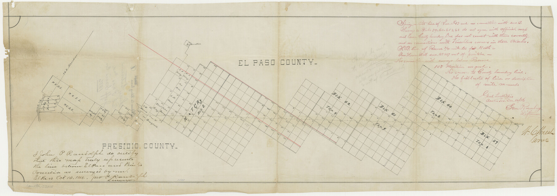
El Paso County Boundary File 1
Line between El Paso and Jeff Davis Co.
-
Map/Doc
53015
-
Collection
General Map Collection
-
Counties
El Paso
-
Subjects
County Boundaries
-
Height x Width
12.3 x 35.0 inches
31.2 x 88.9 cm
Part of: General Map Collection

United States - Gulf Coast - From Latitude 26° 33' to the Rio Grande Texas

Print $20.00
- Digital $50.00
United States - Gulf Coast - From Latitude 26° 33' to the Rio Grande Texas
1916
Size 27.8 x 18.3 inches
Map/Doc 72837
Red River, Bois D'Arc Creek Floodway Sheet No. 1

Print $20.00
- Digital $50.00
Red River, Bois D'Arc Creek Floodway Sheet No. 1
1915
Size 28.8 x 25.9 inches
Map/Doc 69656
Sketch showing the progress of the survey in Sections 8 & 9 from 1846 to 1882

Print $20.00
- Digital $50.00
Sketch showing the progress of the survey in Sections 8 & 9 from 1846 to 1882
Size 21.8 x 37.2 inches
Map/Doc 96560
Map of Great Britain and Ireland engraved to illustrate Mitchell's new intermediate geography

Print $20.00
- Digital $50.00
Map of Great Britain and Ireland engraved to illustrate Mitchell's new intermediate geography
1885
Size 12.2 x 9.0 inches
Map/Doc 93527


Map of Fannin County

Print $40.00
- Digital $50.00
Map of Fannin County
1841
Size 50.4 x 46.8 inches
Map/Doc 7821
Bosque County Working Sketch 11

Print $20.00
- Digital $50.00
Bosque County Working Sketch 11
1952
Size 10.8 x 30.4 inches
Map/Doc 67444
Crockett County Working Sketch 35

Print $20.00
- Digital $50.00
Crockett County Working Sketch 35
1927
Size 20.2 x 25.5 inches
Map/Doc 68368
![94158, Austin Street Map [Recto], General Map Collection](https://historictexasmaps.com/wmedia_w700/maps/94158.tif.jpg)
Starr County Working Sketch 19

Print $20.00
- Digital $50.00
Starr County Working Sketch 19
1982
Size 27.3 x 33.9 inches
Map/Doc 63935
You may also like
Texas Intracoastal Waterway - Laguna Madre - Dagger Hill to Potrero Grande

Print $20.00
- Digital $50.00
Texas Intracoastal Waterway - Laguna Madre - Dagger Hill to Potrero Grande
1960
Size 38.7 x 27.2 inches
Map/Doc 73510
Nueces County Working Sketch 9

Print $20.00
- Digital $50.00
Nueces County Working Sketch 9
1977
Size 36.1 x 24.1 inches
Map/Doc 71311
Madison County Working Sketch 7

Print $20.00
- Digital $50.00
Madison County Working Sketch 7
1982
Size 12.7 x 17.4 inches
Map/Doc 70769
Denton County Working Sketch 36

Print $20.00
- Digital $50.00
Denton County Working Sketch 36
2008
Size 18.5 x 29.0 inches
Map/Doc 88877
Texas and the Great War

Print $20.00
- Digital $50.00
Texas and the Great War
2017
Size 24.3 x 18.3 inches
Map/Doc 94412
Orange County Sketch File 9

Print $20.00
- Digital $50.00
Orange County Sketch File 9
1874
Size 12.7 x 22.9 inches
Map/Doc 12117
Harris County Sketch File 100

Print $518.00
- Digital $50.00
Harris County Sketch File 100
1991
Size 11.5 x 8.8 inches
Map/Doc 25674
Revised Map of Pep Located on Labor 11, League 699 Texas State Capitol Lands Hockley County, Texas

Print $20.00
- Digital $50.00
Revised Map of Pep Located on Labor 11, League 699 Texas State Capitol Lands Hockley County, Texas
1927
Size 16.9 x 15.7 inches
Map/Doc 92204
Leon County Rolled Sketch 6

Print $20.00
- Digital $50.00
Leon County Rolled Sketch 6
1951
Size 31.6 x 37.6 inches
Map/Doc 6597
Carte du Canada et de la Louisiane qui forment la Nouvelle France et des colonies angloises ou sont representez les pays contestez

Print $20.00
- Digital $50.00
Carte du Canada et de la Louisiane qui forment la Nouvelle France et des colonies angloises ou sont representez les pays contestez
1756
Size 21.5 x 29.6 inches
Map/Doc 97415
Stonewall County Rolled Sketch 14

Print $20.00
- Digital $50.00
Stonewall County Rolled Sketch 14
1902
Size 32.9 x 25.2 inches
Map/Doc 7869
Ward County Rolled Sketch 17

Print $20.00
- Digital $50.00
Ward County Rolled Sketch 17
1947
Size 16.2 x 19.5 inches
Map/Doc 8160