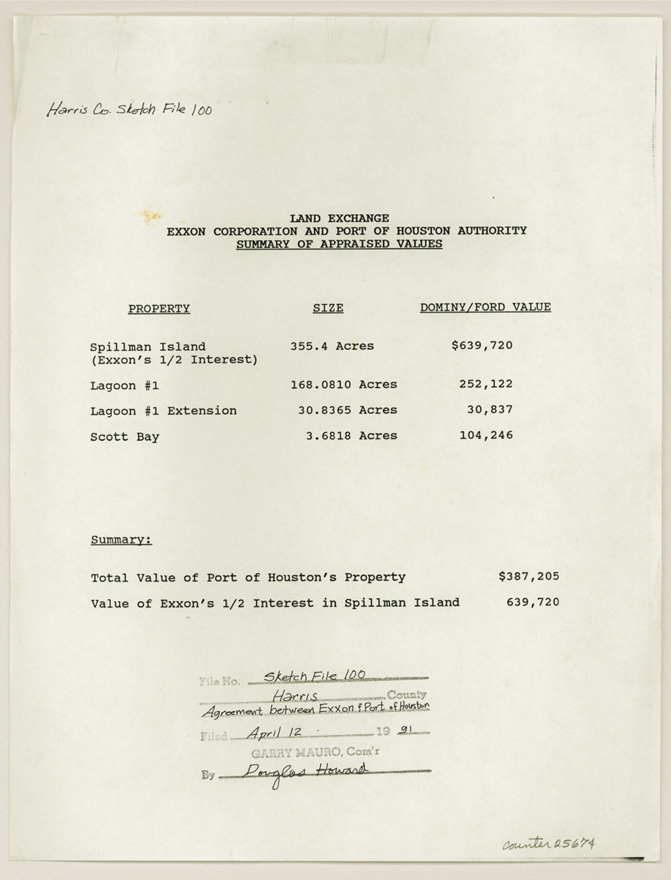
Harris County Sketch File 100
Map of Survey of the boundary of Scotts Bay as Based on Mean High Water Having an Elevation of 0.72 ft. (N. G. V. D. 1979 Adj.) in Harris County, Texas
-
Map/Doc
25674
-
Collection
General Map Collection
-
Object Dates
1991/3/5 (Creation Date)
1991/4/12 (File Date)
1990/1/16 (Correspondence Date)
1939 (Survey Date)
1939 (Survey Date)
1983/9/19 (Survey Date)
-
People and Organizations
Garry Mauro (GLO Commissioner)
Larry C. Washburn (Surveyor/Engineer)
James M. Washburn (Surveyor/Engineer)
-
Counties
Harris Galveston Brazoria Fort Bend Liberty Montgomery Waller Chambers
-
Subjects
Surveying Sketch File
-
Height x Width
11.5 x 8.8 inches
29.2 x 22.4 cm
-
Medium
multi-page, multi-format
-
Features
Highway 6
Wisconsin Street
Spillman Island
Lagoon #1
Scott Bay
Port of Houston
La Porte
Black Duck Bay
Houston Ship Channel
State Highway 146
Barbours Cut
Bayway Drive
Bay Villa Subdivision
Waller
Tomball
Woodlands
Jersey Village
Shenandoah
Chateau Woods
Oak Ridge North
Westfield
Woodbranch Village
Roman Forest
Porte
Dayton
Eastgate
Mont Belvieu
Baytown
San Jacinto
Spring Valley
Hunter Creek
Blinker Hill
Katy
West University Place
Brookshire
Fulshear
Rosenberg
Sugarland
Stafford
Southside Place
Sours City
Brookside Village
La Porte Freeway
South Belt
Clear Lake City
Taylor Lake Village
Clear Lake Shores
Friendswood
Dickinson
League City
Pearland
Mansel
Mitchell Bay
Houston
University of Houston
University of Houston Downtown
University of Houston at Clear Lake City
Rice University
Texas Southern University
University of St. Thomas
Houston Baptist University
South Texas College of Law
University of Texas Health Science Cente
Baylor College of Medicine
Houston Baptist University School of Nursing
Texas Chiropractic College
University of St. Thomas School of Nursing
Methodist Hospital
Texas Medical Center
San Jacinto State Park
San Jacinto Monument
Battleship Texas
Intercoastal Waterway
Interstate Highway 10
Interstate Highway 45
U.S. Highway 59
U.S. Highway 90
U.S. Highway 290
Interstate Highway 610
Sam Houston Tollway
Beltway 8
Grand Parkway
Houston Intercontinental Airport
Hobby Airport
Lake Houston
Lake Conroe
Lake Livingston
Galveston Bay
Point Bolivar
Buffalo Bayou
Clinton Island
Penn City Road
Greens Bayou
State Highway 225
Trinity River
Lynchburg Ferry
Southern Pacific Railroad Company
Burlington Northern
MP
AT&SF
MK&T
Lost Lake Island
Atkinson Island
Cedar Bayou Channel
Mont Belview
Jacintoport Boulevard
Federal Road
Witter Street
Cotton Patch Bayou
Washburn Tunnel
Battleground Road
Carpenters Bayou Barge Canal
Jacintoport Boat Slip
Sheldon Road
San Jacinto River
Market Street Road
Burnette Bay
North Burnette
Tabbs Bay
Channelview
Old River Terrace
Crystal Lake
Wooster Subdivision
Brownwood Subdivision
Peggy Lake
Mitchell Bay
Deer Park
Lomax
Houston Suburban Railway
Morrell Park
Goose Creek
Goose Creek Subdivision
McKie Peninsula
Hog Island
Cedar Bayou
Morgan's Point
Greens Bayou Park
Cloverleaf
Carpenters Bayou
Hunting Bayou
Pasadena
Lynchburg Road
San Jacinto Oaks
Lakeview Heights
Oakland Estates
Hog Island
Alexander (Busch) Island
Trinity Bay
Jennings Island
Bayland Park Site
Blackwell Peninsula
Bayshore Drive
Missouri Street
Oklahoma Street
East Baytown Addition
McKee Peninsula
San Jacinto Bay
Part of: General Map Collection
El Paso County Boundary File 2

Print $28.00
- Digital $50.00
El Paso County Boundary File 2
Size 13.2 x 8.2 inches
Map/Doc 53021
Montgomery County Sketch File 40

Print $8.00
- Digital $50.00
Montgomery County Sketch File 40
1914
Size 11.3 x 8.8 inches
Map/Doc 31925
Mosaic composed of aerial photographs - Houston Ship Channel, Tex.

Print $20.00
- Digital $50.00
Mosaic composed of aerial photographs - Houston Ship Channel, Tex.
1923
Size 13.7 x 38.0 inches
Map/Doc 97172
Bexar County Working Sketch Graphic Index

Print $20.00
- Digital $50.00
Bexar County Working Sketch Graphic Index
1932
Size 47.9 x 42.6 inches
Map/Doc 76466
Presidio County Rolled Sketch 37

Print $20.00
- Digital $50.00
Presidio County Rolled Sketch 37
Size 15.6 x 22.6 inches
Map/Doc 7335
Flight Mission No. CRE-3R, Frame 38, Jackson County

Print $20.00
- Digital $50.00
Flight Mission No. CRE-3R, Frame 38, Jackson County
1956
Size 18.6 x 22.2 inches
Map/Doc 85384
Red River County Working Sketch 30

Print $20.00
- Digital $50.00
Red River County Working Sketch 30
1962
Size 25.2 x 22.8 inches
Map/Doc 72013
The Latest Map of Texas

Print $20.00
- Digital $50.00
The Latest Map of Texas
1889
Size 32.0 x 34.0 inches
Map/Doc 93422
St. Louis, Brownsville & Mexico Railway Location Map from Mile 100 to Mile 120

Print $40.00
- Digital $50.00
St. Louis, Brownsville & Mexico Railway Location Map from Mile 100 to Mile 120
1905
Size 20.0 x 61.2 inches
Map/Doc 64167
Pecos County Working Sketch 100

Print $20.00
- Digital $50.00
Pecos County Working Sketch 100
1970
Size 42.9 x 31.6 inches
Map/Doc 71573
Bowie County Working Sketch 11

Print $20.00
- Digital $50.00
Bowie County Working Sketch 11
1958
Size 43.2 x 31.6 inches
Map/Doc 67415
Reeves County Sketch File 4

Print $20.00
- Digital $50.00
Reeves County Sketch File 4
Size 32.8 x 12.2 inches
Map/Doc 12240
You may also like
Cherokee County Sketch File 20

Print $4.00
- Digital $50.00
Cherokee County Sketch File 20
1876
Size 8.2 x 6.0 inches
Map/Doc 18163
General Highway Map, Upton County, Texas

Print $20.00
General Highway Map, Upton County, Texas
1940
Size 24.8 x 18.1 inches
Map/Doc 79265

Flight Mission No. BRA-7M, Frame 5, Jefferson County

Print $20.00
- Digital $50.00
Flight Mission No. BRA-7M, Frame 5, Jefferson County
1953
Size 18.6 x 22.2 inches
Map/Doc 85456
Cooke County Sketch File 21

Print $4.00
- Digital $50.00
Cooke County Sketch File 21
Size 9.0 x 6.7 inches
Map/Doc 19265
Wortham & Williams' Subdivisions of the San Augustine County School Leagues situated in Lubbock Co., Texas

Print $40.00
- Digital $50.00
Wortham & Williams' Subdivisions of the San Augustine County School Leagues situated in Lubbock Co., Texas
1909
Size 38.7 x 52.1 inches
Map/Doc 89935
Reagan County Rolled Sketch 29A

Print $20.00
- Digital $50.00
Reagan County Rolled Sketch 29A
1954
Size 36.4 x 36.3 inches
Map/Doc 9825
Hardin County Rolled Sketch WS

Print $20.00
- Digital $50.00
Hardin County Rolled Sketch WS
1936
Size 25.4 x 43.9 inches
Map/Doc 9104
Hutchinson County Rolled Sketch 18

Print $20.00
- Digital $50.00
Hutchinson County Rolled Sketch 18
Size 30.4 x 32.6 inches
Map/Doc 9244
Val Verde County Sketch File Z22

Print $4.00
- Digital $50.00
Val Verde County Sketch File Z22
1919
Size 11.2 x 8.6 inches
Map/Doc 39163
Johnson County

Print $20.00
- Digital $50.00
Johnson County
1943
Size 39.8 x 37.0 inches
Map/Doc 77332
Archer County Working Sketch 10b

Print $20.00
- Digital $50.00
Archer County Working Sketch 10b
1924
Size 25.5 x 40.2 inches
Map/Doc 67151