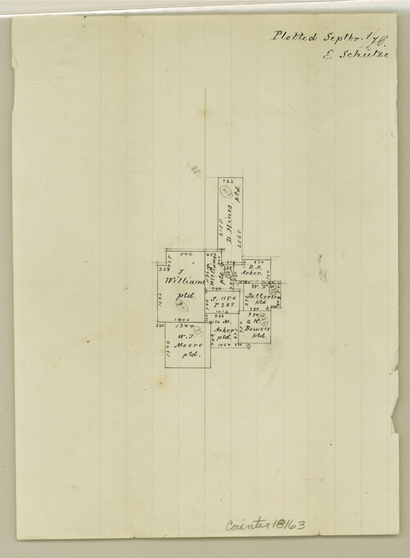
Cherokee County Sketch File 20
[Office sketch of area around the J. Williams survey west of Rusk]
-
Map/Doc
18163
-
Collection
General Map Collection
-
Object Dates
1876/9/1 (Creation Date)
1876/9/1 (File Date)
-
People and Organizations
E. Schutze (Draftsman)
-
Counties
Cherokee
-
Subjects
Surveying Sketch File
-
Height x Width
8.2 x 6.0 inches
20.8 x 15.2 cm
-
Medium
paper, manuscript
Part of: General Map Collection
Liberty County Sketch File 61

Print $12.00
- Digital $50.00
Liberty County Sketch File 61
1950
Size 14.2 x 8.8 inches
Map/Doc 30077
Flight Mission No. CON-4R, Frame 200, Stonewall County

Print $20.00
- Digital $50.00
Flight Mission No. CON-4R, Frame 200, Stonewall County
1957
Size 18.2 x 22.0 inches
Map/Doc 86994
San Patricio County Sketch File 48

Print $88.00
- Digital $50.00
San Patricio County Sketch File 48
Size 9.0 x 9.0 inches
Map/Doc 36285
Liberty County Sketch File 41

Print $2.00
- Digital $50.00
Liberty County Sketch File 41
1872
Size 12.5 x 8.5 inches
Map/Doc 29997
Schleicher County Working Sketch 10

Print $20.00
- Digital $50.00
Schleicher County Working Sketch 10
1923
Size 18.3 x 16.4 inches
Map/Doc 63812
Shackelford County Boundary File 1

Print $17.00
- Digital $50.00
Shackelford County Boundary File 1
Size 14.0 x 8.7 inches
Map/Doc 58625
Pecos County Sketch File 14A

Print $20.00
- Digital $50.00
Pecos County Sketch File 14A
Size 33.7 x 23.0 inches
Map/Doc 12158
Hutchinson County Rolled Sketch 44-9

Print $20.00
- Digital $50.00
Hutchinson County Rolled Sketch 44-9
2002
Size 24.0 x 36.0 inches
Map/Doc 77545
Wichita County Sketch File 12a

Print $10.00
- Digital $50.00
Wichita County Sketch File 12a
1881
Size 14.2 x 8.6 inches
Map/Doc 40077
Flight Mission No. BRA-7M, Frame 118, Jefferson County

Print $20.00
- Digital $50.00
Flight Mission No. BRA-7M, Frame 118, Jefferson County
1953
Size 18.6 x 22.2 inches
Map/Doc 85512
Jeff Davis County Sketch File 8

Print $20.00
- Digital $50.00
Jeff Davis County Sketch File 8
1889
Size 19.5 x 28.5 inches
Map/Doc 11857
Culberson County Sketch File 2

Print $20.00
- Digital $50.00
Culberson County Sketch File 2
1882
Size 28.9 x 36.4 inches
Map/Doc 11261
You may also like
Sketch G Showing the Progress of the Survey in Section VII From 1849 to 1852

Print $20.00
- Digital $50.00
Sketch G Showing the Progress of the Survey in Section VII From 1849 to 1852
1852
Size 13.6 x 25.8 inches
Map/Doc 97219
Reagan County Working Sketch 13

Print $40.00
- Digital $50.00
Reagan County Working Sketch 13
1948
Size 23.8 x 50.8 inches
Map/Doc 71853
[Leagues 11 and 22]
![91111, [Leagues 11 and 22], Twichell Survey Records](https://historictexasmaps.com/wmedia_w700/maps/91111-1.tif.jpg)
Print $20.00
- Digital $50.00
[Leagues 11 and 22]
1925
Size 14.0 x 13.6 inches
Map/Doc 91111
Real County Rolled Sketch 18

Print $20.00
- Digital $50.00
Real County Rolled Sketch 18
Size 22.0 x 27.9 inches
Map/Doc 7460
Flight Mission No. BRE-1P, Frame 123, Nueces County

Print $20.00
- Digital $50.00
Flight Mission No. BRE-1P, Frame 123, Nueces County
1956
Size 18.6 x 22.7 inches
Map/Doc 86689
Reagan County Working Sketch 43

Print $20.00
- Digital $50.00
Reagan County Working Sketch 43
1984
Size 36.4 x 27.1 inches
Map/Doc 71885
Austin, Texas Congress Ave. Drainage

Print $20.00
- Digital $50.00
Austin, Texas Congress Ave. Drainage
1903
Size 15.1 x 15.5 inches
Map/Doc 75797
Van Zandt County Sketch File 5

Print $22.00
- Digital $50.00
Van Zandt County Sketch File 5
Size 20.5 x 6.3 inches
Map/Doc 39371
Outer Continental Shelf Leasing Maps (Texas Offshore Operations)

Print $20.00
- Digital $50.00
Outer Continental Shelf Leasing Maps (Texas Offshore Operations)
Size 24.0 x 18.4 inches
Map/Doc 75853
Flight Mission No. DIX-10P, Frame 176, Aransas County

Print $20.00
- Digital $50.00
Flight Mission No. DIX-10P, Frame 176, Aransas County
1956
Size 18.6 x 22.3 inches
Map/Doc 83966
Montague County Rolled Sketch 2

Print $20.00
- Digital $50.00
Montague County Rolled Sketch 2
1940
Size 32.5 x 35.5 inches
Map/Doc 9525
The North Part of America

Print $20.00
- Digital $50.00
The North Part of America
1625
Size 13.1 x 14.8 inches
Map/Doc 93815