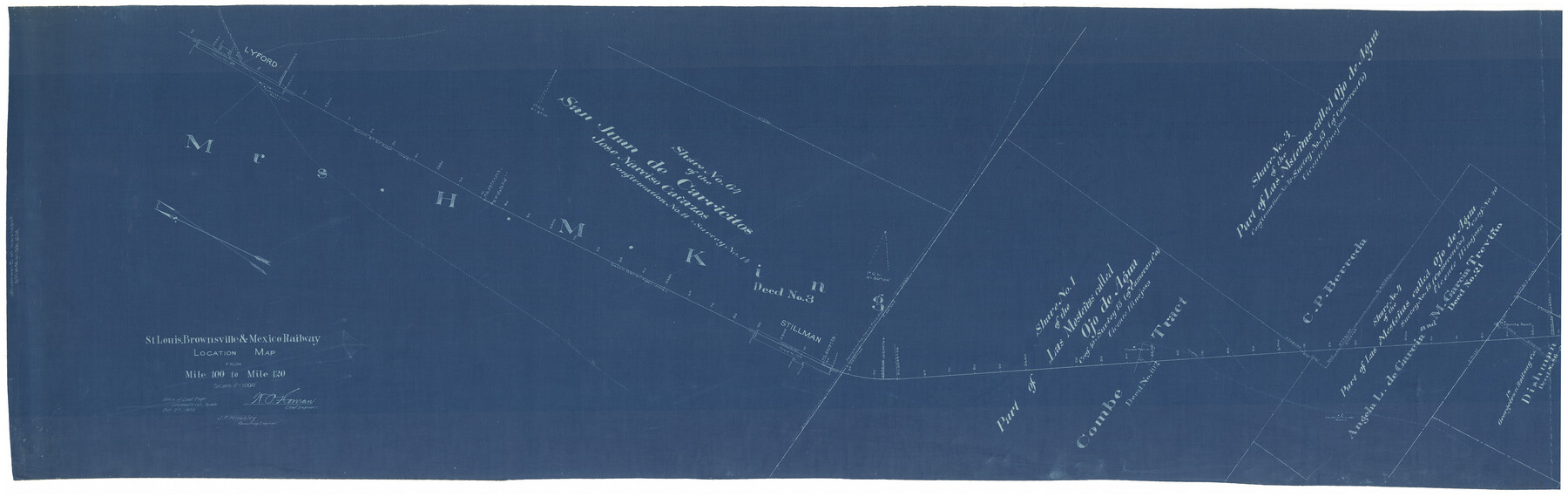
St. Louis, Brownsville & Mexico Railway Location Map from Mile 100 to Mile 120
Z-2-47
-
Map/Doc
64167
-
Collection
General Map Collection
-
Object Dates
10/27/1905 (Creation Date)
-
People and Organizations
J.F. Hinckley (Surveyor/Engineer)
W.O. Homan (Surveyor/Engineer)
-
Counties
Willacy
-
Subjects
Railroads
-
Height x Width
20.0 x 61.2 inches
50.8 x 155.5 cm
-
Medium
blueprint/diazo
-
Scale
1" = 1000'
-
Comments
See counters 64165 through 64170 for all sheets.
-
Features
SLB&M
Lyford
Stillman
Como se Llamo Ranch
Comde Ranch
Cerdo Santander Ranch
Ebonita Ranch
Santa Rita and Santa Rosa Road
Como se Llamo Road
Part of: General Map Collection

Map of the County of Calhoun

Print $20.00
- Digital $50.00
Map of the County of Calhoun
1852
Size 21.0 x 20.4 inches
Map/Doc 4431
Chambers County Sketch File 20

Print $4.00
- Digital $50.00
Chambers County Sketch File 20
Size 9.2 x 7.4 inches
Map/Doc 17591
Flight Mission No. CRC-1R, Frame 95, Chambers County

Print $20.00
- Digital $50.00
Flight Mission No. CRC-1R, Frame 95, Chambers County
1956
Size 18.7 x 22.3 inches
Map/Doc 84710
Map of Donley County

Print $20.00
- Digital $50.00
Map of Donley County
1894
Size 44.6 x 35.8 inches
Map/Doc 16823
Texas Pacific Land Trust, Preliminary Plat Blocks 64-65-66 Tsp. 7 & 8 T&P RR Co. Surveys

Print $40.00
- Digital $50.00
Texas Pacific Land Trust, Preliminary Plat Blocks 64-65-66 Tsp. 7 & 8 T&P RR Co. Surveys
1962
Size 54.6 x 43.0 inches
Map/Doc 87210
Fisher County Rolled Sketch 7

Print $20.00
- Digital $50.00
Fisher County Rolled Sketch 7
2009
Size 28.6 x 24.6 inches
Map/Doc 89988
Edwards County Working Sketch 103

Print $20.00
- Digital $50.00
Edwards County Working Sketch 103
1972
Size 25.6 x 44.3 inches
Map/Doc 68979
Jasper County Working Sketch 24

Print $40.00
- Digital $50.00
Jasper County Working Sketch 24
1948
Size 44.2 x 54.9 inches
Map/Doc 69651
Crane County Rolled Sketch 4

Print $40.00
- Digital $50.00
Crane County Rolled Sketch 4
Size 34.7 x 51.9 inches
Map/Doc 8337
Cottle County Sketch File 14

Print $50.00
- Digital $50.00
Cottle County Sketch File 14
1918
Size 11.3 x 8.8 inches
Map/Doc 19491
Presidio County Rolled Sketch 126

Print $20.00
- Digital $50.00
Presidio County Rolled Sketch 126
1986
Size 27.8 x 39.4 inches
Map/Doc 7397
You may also like
Robertson County Working Sketch 2

Print $20.00
- Digital $50.00
Robertson County Working Sketch 2
1939
Size 14.5 x 16.3 inches
Map/Doc 63575
North America

Print $20.00
- Digital $50.00
North America
1823
Size 21.9 x 25.6 inches
Map/Doc 93842
Polk County Working Sketch 17

Print $20.00
- Digital $50.00
Polk County Working Sketch 17
1948
Size 28.3 x 18.5 inches
Map/Doc 71632
Webb County Rolled Sketch 78A

Print $20.00
- Digital $50.00
Webb County Rolled Sketch 78A
Size 28.4 x 23.0 inches
Map/Doc 90053
Flight Mission No. BRE-2P, Frame 14, Nueces County

Print $20.00
- Digital $50.00
Flight Mission No. BRE-2P, Frame 14, Nueces County
1956
Size 18.5 x 22.6 inches
Map/Doc 86723
Sketch in Crockett County [showing University Land Blocks 46-51]
![90312, Sketch in Crockett County [showing University Land Blocks 46-51], Twichell Survey Records](https://historictexasmaps.com/wmedia_w700/maps/90312-1.tif.jpg)
Print $20.00
- Digital $50.00
Sketch in Crockett County [showing University Land Blocks 46-51]
1915
Size 10.6 x 20.1 inches
Map/Doc 90312
San Patricio County Rolled Sketch 38

Print $20.00
- Digital $50.00
San Patricio County Rolled Sketch 38
1950
Size 15.6 x 15.7 inches
Map/Doc 7588
Real County Rolled Sketch 1

Print $20.00
- Digital $50.00
Real County Rolled Sketch 1
1941
Size 20.6 x 28.9 inches
Map/Doc 7452
Jasper County Working Sketch 13

Print $20.00
- Digital $50.00
Jasper County Working Sketch 13
1920
Size 24.3 x 17.1 inches
Map/Doc 66475
Official Highway Map of Texas

Print $20.00
Official Highway Map of Texas
1926
Size 25.0 x 24.9 inches
Map/Doc 79744
Blanco County Working Sketch 10

Print $20.00
- Digital $50.00
Blanco County Working Sketch 10
1938
Size 28.3 x 25.8 inches
Map/Doc 67370
Galveston County Rolled Sketch JR

Print $20.00
- Digital $50.00
Galveston County Rolled Sketch JR
1938
Size 37.5 x 36.7 inches
Map/Doc 9086