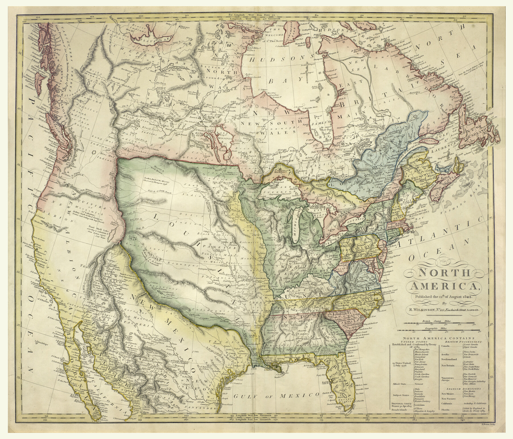
North America
-
Map/Doc
93842
-
Collection
Holcomb Map Collection
-
Object Dates
8/12/1823 (Creation Date)
-
People and Organizations
R. Wilkinson (Author)
-
Subjects
North America
-
Height x Width
21.9 x 25.6 inches
55.6 x 65.0 cm
-
Comments
Courtesy of Frank and Carol Holcomb.
Part of: Holcomb Map Collection
Map of South America designed to accompany Smith's Geography of Schools

Print $20.00
- Digital $50.00
Map of South America designed to accompany Smith's Geography of Schools
1850
Size 12.0 x 9.8 inches
Map/Doc 93891
Map of Texas with parts of the Adjoining States

Print $20.00
- Digital $50.00
Map of Texas with parts of the Adjoining States
1830
Size 29.6 x 24.1 inches
Map/Doc 94440
A Map of the United States of Mexico as organized and defined by the several Acts of the Congress of that Republic

Print $20.00
- Digital $50.00
A Map of the United States of Mexico as organized and defined by the several Acts of the Congress of that Republic
1847
Size 24.3 x 30.6 inches
Map/Doc 93876
Map of Texas to accompany "Brady's Glimpses of Texas"

Print $20.00
- Digital $50.00
Map of Texas to accompany "Brady's Glimpses of Texas"
1871
Size 13.0 x 16.1 inches
Map/Doc 93907
Map of the West Indies designed to accompany Smith's Geography for Schools

Print $20.00
- Digital $50.00
Map of the West Indies designed to accompany Smith's Geography for Schools
1850
Size 9.6 x 12.0 inches
Map/Doc 93893
Novissima et Accuratissima Totius Americae Descriptio

Print $20.00
- Digital $50.00
Novissima et Accuratissima Totius Americae Descriptio
1677
Size 20.9 x 25.0 inches
Map/Doc 93819
Traveller's Map of the State of Texas

Print $20.00
- Digital $50.00
Traveller's Map of the State of Texas
1867
Size 43.4 x 41.6 inches
Map/Doc 93906
A New Map of Texas, Oregon and California with the regions adjoining, compiled from the most recent authorities

Print $20.00
- Digital $50.00
A New Map of Texas, Oregon and California with the regions adjoining, compiled from the most recent authorities
1846
Size 23.2 x 21.2 inches
Map/Doc 93872
[Map of the Texas & Pacific Railway and connections]
![95414, [Map of the Texas & Pacific Railway and connections], Holcomb Digital Map Collection](https://historictexasmaps.com/wmedia_w700/maps/95414.tif.jpg)
Print $20.00
- Digital $50.00
[Map of the Texas & Pacific Railway and connections]
1902
Size 18.0 x 37.0 inches
Map/Doc 95414
The History of the Republic of Texas, from the discovery of the country to the present time; and the cause of her separation from the Republic of Mexico.

Print $1080.00
- Digital $50.00
The History of the Republic of Texas, from the discovery of the country to the present time; and the cause of her separation from the Republic of Mexico.
1842
Size 9.3 x 6.1 inches
Map/Doc 93866


You may also like
Colorado County Sketch File 35

Print $13.00
- Digital $50.00
Colorado County Sketch File 35
2005
Size 44.0 x 28.0 inches
Map/Doc 83564
Tracing of J. M. Morgan's Map Showing X-LIT Fence Line

Print $20.00
- Digital $50.00
Tracing of J. M. Morgan's Map Showing X-LIT Fence Line
1916
Size 9.5 x 22.7 inches
Map/Doc 91809
Cooke County Rolled Sketch 5

Print $20.00
- Digital $50.00
Cooke County Rolled Sketch 5
1980
Size 18.2 x 24.0 inches
Map/Doc 5563
Map of Tom Green County

Print $40.00
- Digital $50.00
Map of Tom Green County
1892
Size 43.2 x 48.3 inches
Map/Doc 63070
[Surveys along the Colorado River]
![61, [Surveys along the Colorado River], General Map Collection](https://historictexasmaps.com/wmedia_w700/maps/61.tif.jpg)
Print $20.00
- Digital $50.00
[Surveys along the Colorado River]
1841
Size 14.4 x 16.1 inches
Map/Doc 61
Liberty County

Print $20.00
- Digital $50.00
Liberty County
1862
Size 24.3 x 24.8 inches
Map/Doc 3815
Tyler County Working Sketch 6

Print $20.00
- Digital $50.00
Tyler County Working Sketch 6
1934
Size 24.3 x 36.5 inches
Map/Doc 69476
United States - Gulf Coast Texas - Southern part of Laguna Madre

Print $20.00
- Digital $50.00
United States - Gulf Coast Texas - Southern part of Laguna Madre
1941
Size 26.4 x 18.2 inches
Map/Doc 72956
Menard County Boundary File 12a

Print $14.00
- Digital $50.00
Menard County Boundary File 12a
Size 14.2 x 8.8 inches
Map/Doc 57114
Presidio County

Print $40.00
- Digital $50.00
Presidio County
1875
Size 97.8 x 33.5 inches
Map/Doc 88867
Bexar County State Real Property Sketch 4

Print $20.00
- Digital $50.00
Bexar County State Real Property Sketch 4
2013
Size 25.0 x 36.5 inches
Map/Doc 93692
Cameron County Rolled Sketch 25

Print $40.00
- Digital $50.00
Cameron County Rolled Sketch 25
1977
Size 25.0 x 72.9 inches
Map/Doc 5791