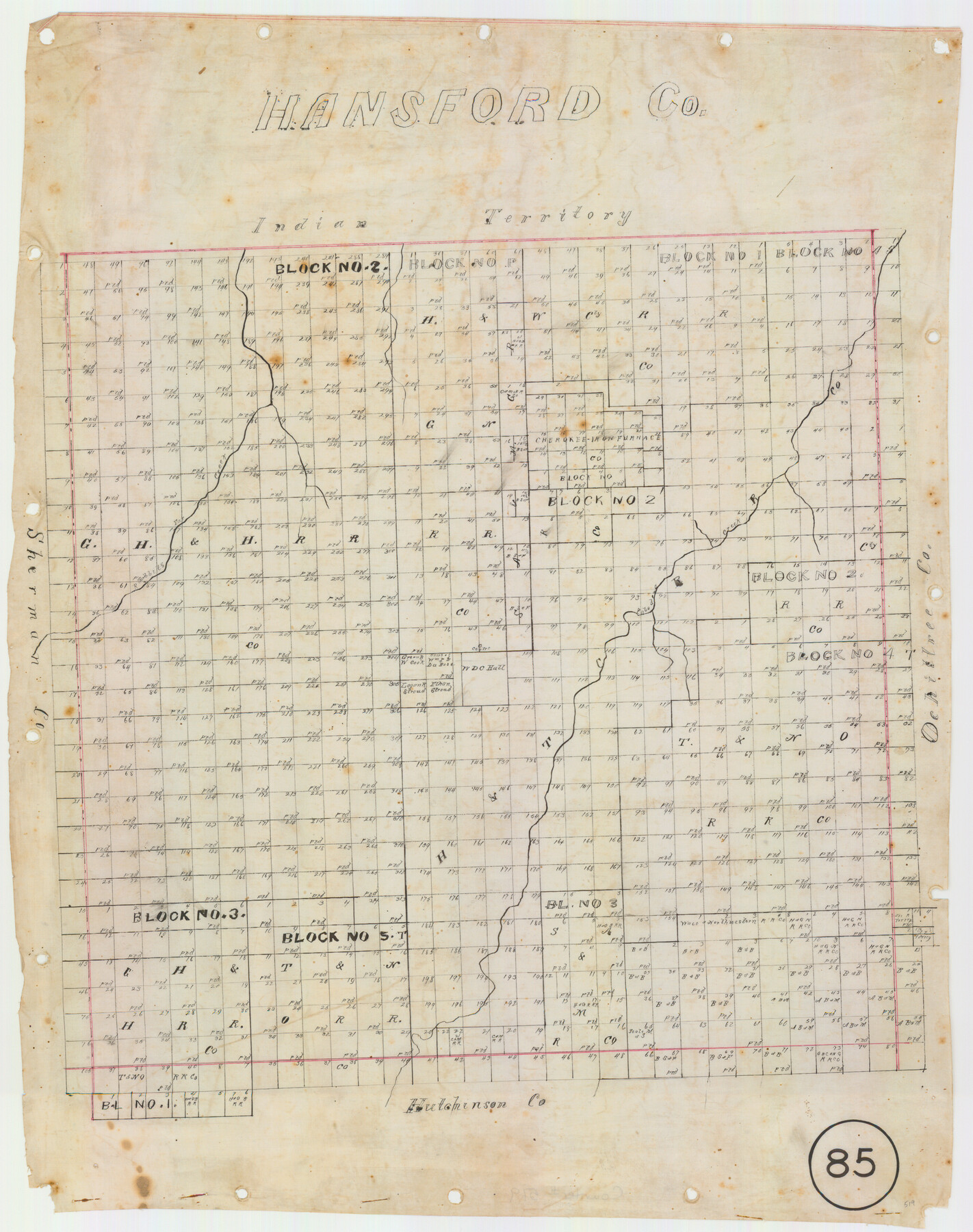
Hansford County, Texas
-
Map/Doc
519
-
Collection
Maddox Collection
-
Object Dates
[1880 ca.] (Creation Date)
-
Counties
Hansford
-
Subjects
County
-
Height x Width
21.4 x 18.0 inches
54.4 x 45.7 cm
-
Medium
linen, manuscript
-
Comments
Conservation funded in 2011.
-
Features
Rabbits Ear Creek
Paladora Creek
Part of: Maddox Collection
[Map Showing Estivan Martinez "Los Nerios de Tio Ayola" Survey and Surveys North Thereof, Brooks County, Texas]
![10755, [Map Showing Estivan Martinez "Los Nerios de Tio Ayola" Survey and Surveys North Thereof, Brooks County, Texas], Maddox Collection](https://historictexasmaps.com/wmedia_w700/maps/10755.tif.jpg)
Print $20.00
- Digital $50.00
[Map Showing Estivan Martinez "Los Nerios de Tio Ayola" Survey and Surveys North Thereof, Brooks County, Texas]
1906
Size 16.7 x 25.1 inches
Map/Doc 10755
Loving County, Texas

Print $20.00
- Digital $50.00
Loving County, Texas
1889
Size 18.8 x 23.8 inches
Map/Doc 638
Knox County, Texas

Print $20.00
- Digital $50.00
Knox County, Texas
1880
Size 27.7 x 23.4 inches
Map/Doc 550
[Sketch Showing Surveys in Schleicher, Menard & Concho Counties, Texas]
![75782, [Sketch Showing Surveys in Schleicher, Menard & Concho Counties, Texas], Maddox Collection](https://historictexasmaps.com/wmedia_w700/maps/75782.tif.jpg)
Print $20.00
- Digital $50.00
[Sketch Showing Surveys in Schleicher, Menard & Concho Counties, Texas]
Size 16.1 x 28.9 inches
Map/Doc 75782
Sketch of Block B, GH & H RR & Blk C, CT RR Co, with surrounding & conflicting surveys in Knox & Baylor Counties

Print $20.00
- Digital $50.00
Sketch of Block B, GH & H RR & Blk C, CT RR Co, with surrounding & conflicting surveys in Knox & Baylor Counties
Size 24.9 x 17.9 inches
Map/Doc 75784
Sketch of Survey 3, Block 1 in Dickens and King Counties

Print $20.00
- Digital $50.00
Sketch of Survey 3, Block 1 in Dickens and King Counties
1914
Size 10.0 x 27.5 inches
Map/Doc 10765
[Map Showing Surveys in Liberty, Chambers and Harris Counties, Texas]
![75768, [Map Showing Surveys in Liberty, Chambers and Harris Counties, Texas], Maddox Collection](https://historictexasmaps.com/wmedia_w700/maps/75768.tif.jpg)
Print $20.00
- Digital $50.00
[Map Showing Surveys in Liberty, Chambers and Harris Counties, Texas]
1890
Size 16.1 x 21.1 inches
Map/Doc 75768
Map of the north west portion of Hutchinson County showing the proposed resurvey of Block M24

Print $20.00
- Digital $50.00
Map of the north west portion of Hutchinson County showing the proposed resurvey of Block M24
Size 29.1 x 31.9 inches
Map/Doc 75814
Working Sketch in Cottle, Foard & Hardeman Counties

Print $20.00
- Digital $50.00
Working Sketch in Cottle, Foard & Hardeman Counties
1917
Size 26.9 x 28.0 inches
Map/Doc 4485
[Sketch of Surveys in Cottle, Dickens, King & Motley Counties, Texas]
![75830, [Sketch of Surveys in Cottle, Dickens, King & Motley Counties, Texas], Maddox Collection](https://historictexasmaps.com/wmedia_w700/maps/75830.tif.jpg)
Print $20.00
- Digital $50.00
[Sketch of Surveys in Cottle, Dickens, King & Motley Counties, Texas]
1913
Size 29.6 x 23.2 inches
Map/Doc 75830
[Surveying Sketch of John Knight, Champion Choate, A.M. Lejarza, et al in Hardin County, Texas - Exhibit "G"]
![75822, [Surveying Sketch of John Knight, Champion Choate, A.M. Lejarza, et al in Hardin County, Texas - Exhibit "G"], Maddox Collection](https://historictexasmaps.com/wmedia_w700/maps/75822.tif.jpg)
Print $20.00
- Digital $50.00
[Surveying Sketch of John Knight, Champion Choate, A.M. Lejarza, et al in Hardin County, Texas - Exhibit "G"]
Size 18.3 x 23.5 inches
Map/Doc 75822
State Land For Sale On Mustang Island by General Land Office

Print $20.00
- Digital $50.00
State Land For Sale On Mustang Island by General Land Office
1910
Size 21.7 x 17.5 inches
Map/Doc 385
You may also like

Ector County Working Sketch 19

Print $40.00
- Digital $50.00
Ector County Working Sketch 19
1958
Size 65.8 x 37.6 inches
Map/Doc 68862
Zavala County Working Sketch 4

Print $20.00
- Digital $50.00
Zavala County Working Sketch 4
1936
Size 21.1 x 23.4 inches
Map/Doc 62079
Working Sketch Compiled from Original Field Showing Surveys in Irion County Located by J. A. McDonald in 1856 and 1858

Print $20.00
- Digital $50.00
Working Sketch Compiled from Original Field Showing Surveys in Irion County Located by J. A. McDonald in 1856 and 1858
Size 13.1 x 13.8 inches
Map/Doc 92191
Hill County Working Sketch Graphic Index

Print $20.00
- Digital $50.00
Hill County Working Sketch Graphic Index
1983
Size 39.8 x 46.9 inches
Map/Doc 76578
Orange County Working Sketch 24

Print $20.00
- Digital $50.00
Orange County Working Sketch 24
1941
Size 12.5 x 14.3 inches
Map/Doc 71356
[Surveys in Austin's Colony along the Navidad River, Caney Fork, and upper Rocky Creek]
![201, [Surveys in Austin's Colony along the Navidad River, Caney Fork, and upper Rocky Creek], General Map Collection](https://historictexasmaps.com/wmedia_w700/maps/201-1.tif.jpg)
Print $20.00
- Digital $50.00
[Surveys in Austin's Colony along the Navidad River, Caney Fork, and upper Rocky Creek]
1831
Size 20.5 x 26.7 inches
Map/Doc 201
[Sketch showing I. & G. N. Block 8]
![91798, [Sketch showing I. & G. N. Block 8], Twichell Survey Records](https://historictexasmaps.com/wmedia_w700/maps/91798-1.tif.jpg)
Print $2.00
- Digital $50.00
[Sketch showing I. & G. N. Block 8]
1919
Size 7.6 x 12.6 inches
Map/Doc 91798
Presidio County Working Sketch 33

Print $40.00
- Digital $50.00
Presidio County Working Sketch 33
1947
Size 41.6 x 50.6 inches
Map/Doc 71710
[Surveys along the Liberty and Hardin County line]
![295, [Surveys along the Liberty and Hardin County line], General Map Collection](https://historictexasmaps.com/wmedia_w700/maps/295.tif.jpg)
Print $2.00
- Digital $50.00
[Surveys along the Liberty and Hardin County line]
1847
Size 13.5 x 7.7 inches
Map/Doc 295

Grayson County Working Sketch 2

Print $20.00
- Digital $50.00
Grayson County Working Sketch 2
1939
Size 27.8 x 40.9 inches
Map/Doc 63241