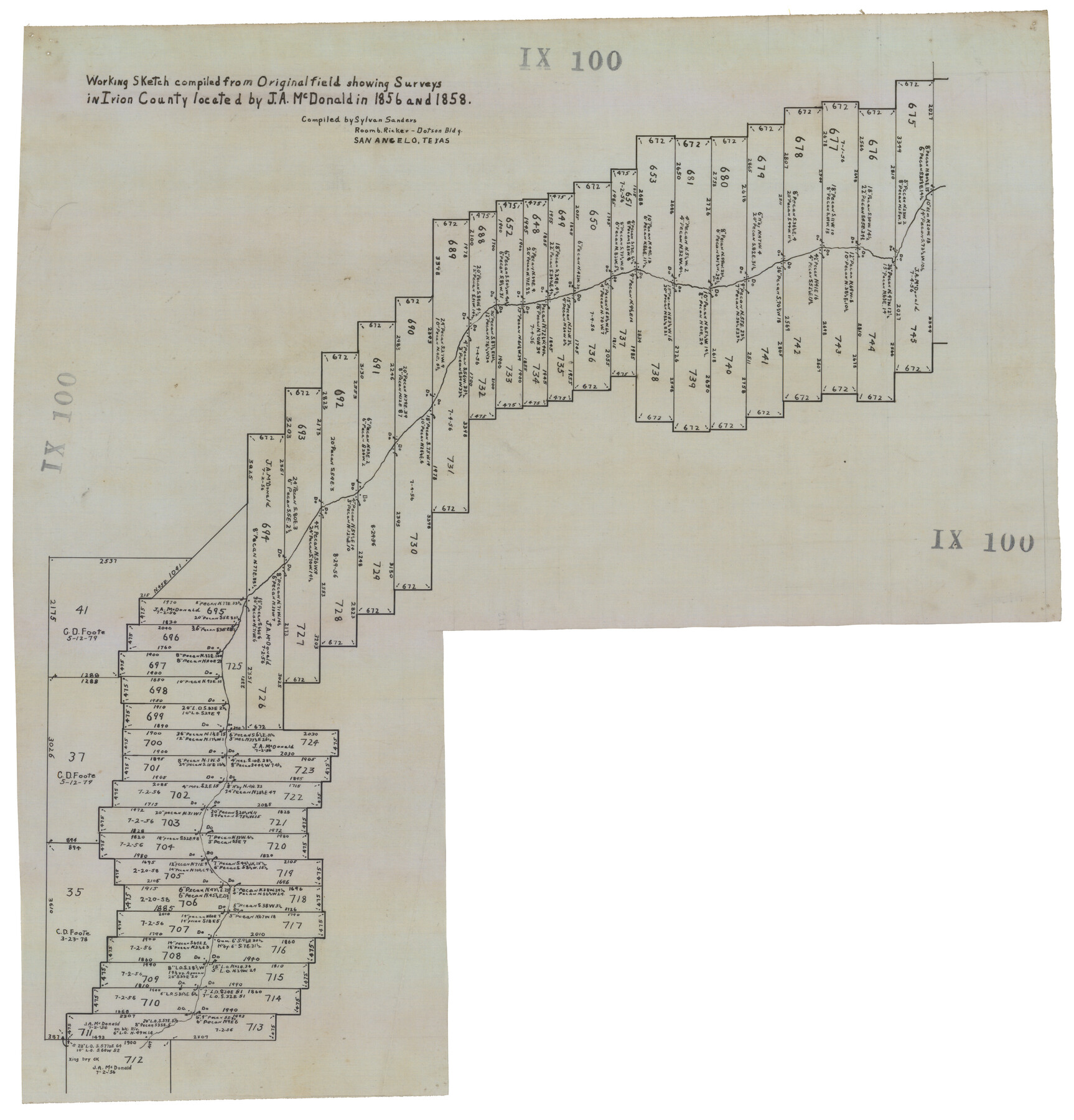
Working Sketch Compiled from Original Field Showing Surveys in Irion County Located by J. A. McDonald in 1856 and 1858
IX100
- 
                          Map/Doc92191
- 
                            CollectionTwichell Survey Records
- 
                            People and OrganizationsSylvan Sanders (Compiler)
- 
                            CountiesIrion
- 
                            Height x Width13.1 x 13.8 inches33.3 x 35.1 cm
Part of: Twichell Survey Records
            [Sketch of surveys in the vicinity of sections 171 and 172 along Pedernales]
            
                                    ![91880, [Sketch of surveys in the vicinity of sections 171 and 172 along Pedernales], Twichell Survey Records](https://historictexasmaps.com/wmedia_w700/maps/91880-1.tif.jpg) 


    ![91880, [Sketch of surveys in the vicinity of sections 171 and 172 along Pedernales], Twichell Survey Records](https://historictexasmaps.com/wmedia_w700/maps/91880-1.tif.jpg) 
                                
            
                                            Print $20.00                    
                                             -                         Digital $50.00                                    
                [Sketch of surveys in the vicinity of sections 171 and 172 along Pedernales]
Size 15.8 x 14.3 inches
                                Map/Doc 91880
            
            [Blotter for Roads in Moore County]
            
                                    ![91530, [Blotter for Roads in Moore County], Twichell Survey Records](https://historictexasmaps.com/wmedia_w700/maps/91530-1.tif.jpg) 


    ![91530, [Blotter for Roads in Moore County], Twichell Survey Records](https://historictexasmaps.com/wmedia_w700/maps/91530-1.tif.jpg) 
                                
            
                                            Print $20.00                    
                                             -                         Digital $50.00                                    
                [Blotter for Roads in Moore County]
Size 32.5 x 32.0 inches
                                Map/Doc 91530
            
            [Part of Map Showing Terry & Lynn County Line Highlighting Parts of Blocks D8, E, 9]
            
                                    ![92264, [Part of Map Showing Terry & Lynn County Line Highlighting Parts of Blocks D8, E, 9], Twichell Survey Records](https://historictexasmaps.com/wmedia_w700/maps/92264-1.tif.jpg) 


    ![92264, [Part of Map Showing Terry & Lynn County Line Highlighting Parts of Blocks D8, E, 9], Twichell Survey Records](https://historictexasmaps.com/wmedia_w700/maps/92264-1.tif.jpg) 
                                
            
                                            Print $20.00                    
                                             -                         Digital $50.00                                    
                [Part of Map Showing Terry & Lynn County Line Highlighting Parts of Blocks D8, E, 9]
Size 18.2 x 10.9 inches
                                Map/Doc 92264
            
            Agua Fria Quadrangle


                                            Print $20.00                    
                                             -                         Digital $50.00                                    
                Agua Fria Quadrangle
1917
Size 17.2 x 21.1 inches
                                Map/Doc 90136
            
            Township 2 North, Block 32]
            
                                    ![91211, Township 2 North, Block 32], Twichell Survey Records](https://historictexasmaps.com/wmedia_w700/maps/91211-1.tif.jpg) 


    ![91211, Township 2 North, Block 32], Twichell Survey Records](https://historictexasmaps.com/wmedia_w700/maps/91211-1.tif.jpg) 
                                
            
                                            Print $2.00                    
                                             -                         Digital $50.00                                    
                Township 2 North, Block 32]
Size 9.0 x 13.7 inches
                                Map/Doc 91211
            
            [PSL Blocks B8-B9, B13-B18 and B22]
            
                                    ![91963, [PSL Blocks B8-B9, B13-B18 and B22], Twichell Survey Records](https://historictexasmaps.com/wmedia_w700/maps/91963-1.tif.jpg) 


    ![91963, [PSL Blocks B8-B9, B13-B18 and B22], Twichell Survey Records](https://historictexasmaps.com/wmedia_w700/maps/91963-1.tif.jpg) 
                                
            
                                            Print $20.00                    
                                             -                         Digital $50.00                                    
                [PSL Blocks B8-B9, B13-B18 and B22]
Size 19.8 x 27.2 inches
                                Map/Doc 91963
            
            West End Place Part of NW Quarter Section 44, Block AK


                                            Print $20.00                    
                                             -                         Digital $50.00                                    
                West End Place Part of NW Quarter Section 44, Block AK
Size 16.0 x 16.4 inches
                                Map/Doc 92346
            
            Laneer vs. Bivins, Potter County, Texas


                                            Print $20.00                    
                                             -                         Digital $50.00                                    
                Laneer vs. Bivins, Potter County, Texas
Size 21.1 x 18.8 inches
                                Map/Doc 93062
            
            M. C. Lindsey's Subdivision of Block 20 College Addition to Lamesa, Texas


                                            Print $20.00                    
                                             -                         Digital $50.00                                    
                M. C. Lindsey's Subdivision of Block 20 College Addition to Lamesa, Texas
1953
Size 9.6 x 18.2 inches
                                Map/Doc 92589
            
            Littlefield, being a part of League 664, Lamb County, Texas


                                            Print $20.00                    
                                             -                         Digital $50.00                                    
                Littlefield, being a part of League 664, Lamb County, Texas
1912
Size 30.5 x 16.9 inches
                                Map/Doc 92150
            
            [LIT Ranch, Gunter & Munson surveys 52-55, Canadian River Meander]
            
                                    ![93011, [LIT Ranch, Gunter & Munson surveys 52-55, Canadian River Meander], Twichell Survey Records](https://historictexasmaps.com/wmedia_w700/maps/93011-1.tif.jpg) 


    ![93011, [LIT Ranch, Gunter & Munson surveys 52-55, Canadian River Meander], Twichell Survey Records](https://historictexasmaps.com/wmedia_w700/maps/93011-1.tif.jpg) 
                                
            
                                            Print $20.00                    
                                             -                         Digital $50.00                                    
                [LIT Ranch, Gunter & Munson surveys 52-55, Canadian River Meander]
Size 18.4 x 12.8 inches
                                Map/Doc 93011
            You may also like
            Presidio County Working Sketch 105


                                            Print $4.00                    
                                             -                         Digital $50.00                                    
                Presidio County Working Sketch 105
1980
Size 27.5 x 27.5 inches
                                Map/Doc 71782
            
            Northeast Part of Webb County


                                            Print $40.00                    
                                             -                         Digital $50.00                                    
                Northeast Part of Webb County
1986
Size 38.0 x 49.2 inches
                                Map/Doc 73318
            
            Brewster County Working Sketch 8


                                            Print $20.00                    
                                             -                         Digital $50.00                                    
                Brewster County Working Sketch 8
1910
Size 42.3 x 30.3 inches
                                Map/Doc 67541
            
            General Highway Map, Fannin County, Texas


                                            Print $20.00                    
                                    
                General Highway Map, Fannin County, Texas
1940
Size 24.9 x 18.5 inches
                                Map/Doc 79087
            
            Brewster County Rolled Sketch 114


                                            Print $20.00                    
                                             -                         Digital $50.00                                    
                Brewster County Rolled Sketch 114
1964
Size 11.5 x 18.2 inches
                                Map/Doc 5286
            
            Reagan County Sketch File 5


                                            Print $12.00                    
                                             -                         Digital $50.00                                    
                Reagan County Sketch File 5
1927
Size 11.2 x 8.7 inches
                                Map/Doc 34980
            
            Callahan County Working Sketch 11


                                            Print $40.00                    
                                             -                         Digital $50.00                                    
                Callahan County Working Sketch 11
1978
Size 43.0 x 48.1 inches
                                Map/Doc 67893
            
            Childress County Sketch File 16


                                            Print $8.00                    
                                             -                         Digital $50.00                                    
                Childress County Sketch File 16
1888
Size 13.9 x 8.5 inches
                                Map/Doc 18282
            
            Hudspeth County Rolled Sketch 26


                                            Print $20.00                    
                                             -                         Digital $50.00                                    
                Hudspeth County Rolled Sketch 26
1909
Size 19.3 x 18.0 inches
                                Map/Doc 6247
            
            Brazos River, Brazos River Sheet 7


                                            Print $20.00                    
                                             -                         Digital $50.00                                    
                Brazos River, Brazos River Sheet 7
1926
Size 22.8 x 27.8 inches
                                Map/Doc 69671
            
            English Field Notes of the Spanish Archives - Book 1


            English Field Notes of the Spanish Archives - Book 1
1833
Map/Doc 96527
             
                        ![91465, [Block B7], Twichell Survey Records](https://historictexasmaps.com/wmedia_w700/maps/91465-1.tif.jpg) 
                                