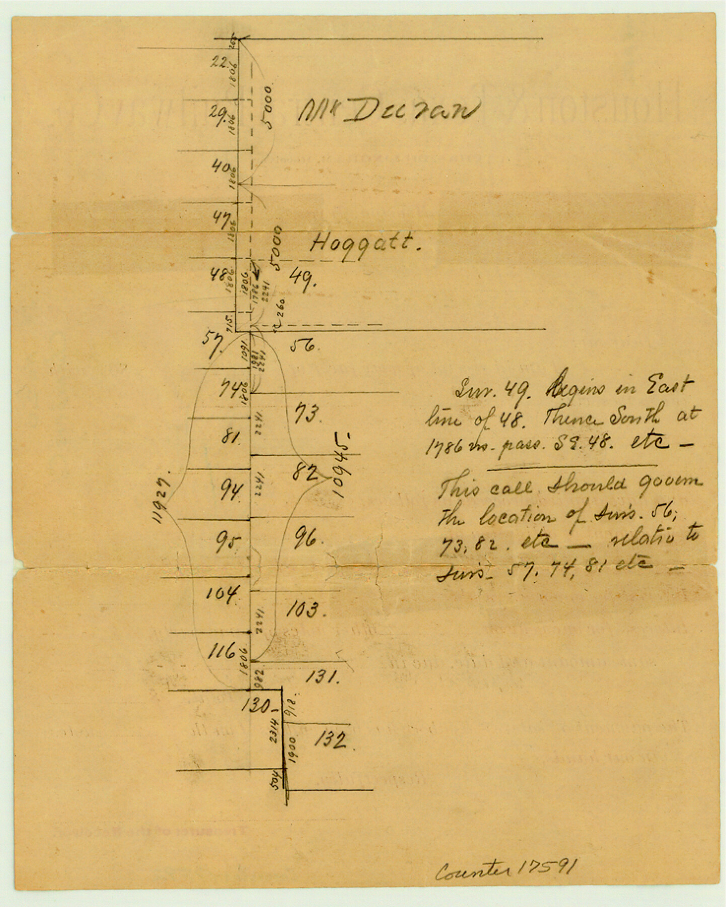
Chambers County Sketch File 20
[Sketch of Duran and Hoggatt surveys and area to the south in the east part of the county]
-
Map/Doc
17591
-
Collection
General Map Collection
-
Counties
Chambers
-
Subjects
Surveying Sketch File
-
Height x Width
9.2 x 7.4 inches
23.4 x 18.8 cm
-
Medium
paper, manuscript
Part of: General Map Collection
Brewster County Rolled Sketch 121
Print $40.00
- Digital $50.00
Brewster County Rolled Sketch 121
1942
Size 43.3 x 92.8 inches
Map/Doc 93790
Harrison County Working Sketch 10

Print $20.00
- Digital $50.00
Harrison County Working Sketch 10
1957
Size 25.8 x 24.6 inches
Map/Doc 66030
Comal County Rolled Sketch 3

Print $20.00
- Digital $50.00
Comal County Rolled Sketch 3
1977
Size 19.0 x 17.3 inches
Map/Doc 5538
Haskell County Boundary File 1

Print $36.00
- Digital $50.00
Haskell County Boundary File 1
Size 8.7 x 9.0 inches
Map/Doc 54518
Dimmit County Rolled Sketch 18

Print $20.00
- Digital $50.00
Dimmit County Rolled Sketch 18
1978
Size 20.2 x 26.0 inches
Map/Doc 5725
Presidio County Working Sketch 23

Print $20.00
- Digital $50.00
Presidio County Working Sketch 23
1945
Size 35.7 x 23.3 inches
Map/Doc 71699
Kinney County Sketch File E

Print $10.00
- Digital $50.00
Kinney County Sketch File E
1885
Size 10.7 x 8.1 inches
Map/Doc 29124
No. 3 Chart of Channel connecting Corpus Christi Bay with Aransas Bay, Texas

Print $20.00
- Digital $50.00
No. 3 Chart of Channel connecting Corpus Christi Bay with Aransas Bay, Texas
1878
Size 18.3 x 27.3 inches
Map/Doc 72781
Flight Mission No. DQN-5K, Frame 57, Calhoun County

Print $20.00
- Digital $50.00
Flight Mission No. DQN-5K, Frame 57, Calhoun County
1953
Size 18.9 x 22.4 inches
Map/Doc 84400
Upton County Sketch File 40a

Print $40.00
- Digital $50.00
Upton County Sketch File 40a
1963
Size 11.2 x 18.3 inches
Map/Doc 38917
Map of subdivision of submerged land in the Gulf of Mexico fronting on Matagorda Island and Peninsula

Print $40.00
- Digital $50.00
Map of subdivision of submerged land in the Gulf of Mexico fronting on Matagorda Island and Peninsula
1940
Size 22.8 x 76.5 inches
Map/Doc 2932
Flight Mission No. CLL-3N, Frame 39, Willacy County

Print $20.00
- Digital $50.00
Flight Mission No. CLL-3N, Frame 39, Willacy County
1954
Size 18.3 x 22.0 inches
Map/Doc 87097
You may also like
Matagorda County Sketch File 10

Print $26.00
- Digital $50.00
Matagorda County Sketch File 10
Size 8.3 x 5.2 inches
Map/Doc 30755

Morris County Rolled Sketch 2A

Print $20.00
- Digital $50.00
Morris County Rolled Sketch 2A
Size 34.7 x 24.7 inches
Map/Doc 10229
[I. & G. N. Block 1 and surroundings]
![91539, [I. & G. N. Block 1 and surroundings], Twichell Survey Records](https://historictexasmaps.com/wmedia_w700/maps/91539-1.tif.jpg)
Print $3.00
- Digital $50.00
[I. & G. N. Block 1 and surroundings]
1892
Size 11.9 x 17.2 inches
Map/Doc 91539
Waco Manufacturing Company Block 1, G. H. & H. Block 5, Capitol Leagues 229, 230, 234-237]
![90726, Waco Manufacturing Company Block 1, G. H. & H. Block 5, Capitol Leagues 229, 230, 234-237], Twichell Survey Records](https://historictexasmaps.com/wmedia_w700/maps/90726-1.tif.jpg)
Print $20.00
- Digital $50.00
Waco Manufacturing Company Block 1, G. H. & H. Block 5, Capitol Leagues 229, 230, 234-237]
1902
Size 14.5 x 21.6 inches
Map/Doc 90726
Flight Mission No. DCL-6C, Frame 130, Kenedy County

Print $20.00
- Digital $50.00
Flight Mission No. DCL-6C, Frame 130, Kenedy County
1943
Size 18.6 x 22.3 inches
Map/Doc 85960

Hamilton County Sketch File 13

Print $40.00
- Digital $50.00
Hamilton County Sketch File 13
1876
Size 12.0 x 16.7 inches
Map/Doc 24935
Eastland County Sketch File 22

Print $33.00
- Digital $50.00
Eastland County Sketch File 22
1964
Size 11.0 x 17.0 inches
Map/Doc 21626
The Judicial District/County of DeWitt. Abolished, Spring 1842

Print $20.00
The Judicial District/County of DeWitt. Abolished, Spring 1842
2020
Size 22.4 x 21.7 inches
Map/Doc 96326
Archer County Sketch File 26

Print $4.00
- Digital $50.00
Archer County Sketch File 26
1934
Size 9.7 x 4.4 inches
Map/Doc 13663
Mason County Sketch File 23

Print $42.00
- Digital $50.00
Mason County Sketch File 23
1932
Size 11.2 x 8.8 inches
Map/Doc 30723