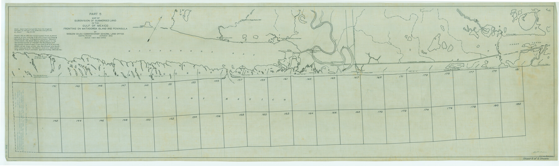
Map of subdivision of submerged land in the Gulf of Mexico fronting on Matagorda Island and Peninsula
K-3-66
-
Map/Doc
2932
-
Collection
General Map Collection
-
Object Dates
1940 (Creation Date)
-
People and Organizations
General Land Office (Publisher)
-
Subjects
Energy Offshore Submerged Area
-
Height x Width
22.8 x 76.5 inches
57.9 x 194.3 cm
Part of: General Map Collection
Garza County Sketch File G-1

Print $20.00
- Digital $50.00
Garza County Sketch File G-1
1904
Size 20.4 x 20.6 inches
Map/Doc 11554
Flight Mission No. CLL-1N, Frame 105, Willacy County

Print $20.00
- Digital $50.00
Flight Mission No. CLL-1N, Frame 105, Willacy County
1954
Size 18.4 x 22.1 inches
Map/Doc 87039
Galveston County Rolled Sketch 34C

Print $20.00
- Digital $50.00
Galveston County Rolled Sketch 34C
1978
Size 29.0 x 40.8 inches
Map/Doc 5969
Harris County Working Sketch 52

Print $20.00
- Digital $50.00
Harris County Working Sketch 52
1947
Size 33.9 x 42.4 inches
Map/Doc 65944
Pecos County Sketch File 36

Print $20.00
- Digital $50.00
Pecos County Sketch File 36
Size 24.9 x 35.3 inches
Map/Doc 12176
Trinity County Sketch File 10

Print $8.00
- Digital $50.00
Trinity County Sketch File 10
1858
Size 13.1 x 8.0 inches
Map/Doc 38527
Jack County Working Sketch 15

Print $20.00
- Digital $50.00
Jack County Working Sketch 15
1982
Size 30.6 x 25.9 inches
Map/Doc 66441
Duval County Working Sketch 58

Print $20.00
- Digital $50.00
Duval County Working Sketch 58
Size 21.0 x 33.0 inches
Map/Doc 67498
Jim Hogg County Rolled Sketch 7

Print $20.00
- Digital $50.00
Jim Hogg County Rolled Sketch 7
1948
Size 32.5 x 28.2 inches
Map/Doc 6442
Hamilton County Sketch File 1

Print $4.00
- Digital $50.00
Hamilton County Sketch File 1
Size 12.5 x 8.2 inches
Map/Doc 24897
Bosque County Sketch File 9

Print $6.00
- Digital $50.00
Bosque County Sketch File 9
1859
Size 4.3 x 4.7 inches
Map/Doc 14754
Upton County Sketch File 4

Print $40.00
- Digital $50.00
Upton County Sketch File 4
1886
Size 19.5 x 9.0 inches
Map/Doc 12510
You may also like
[Texas Boundary Line]
![92081, [Texas Boundary Line], Twichell Survey Records](https://historictexasmaps.com/wmedia_w700/maps/92081-1.tif.jpg)
Print $20.00
- Digital $50.00
[Texas Boundary Line]
Size 21.2 x 12.4 inches
Map/Doc 92081
Tom Green County Boundary File 87a

Print $6.00
- Digital $50.00
Tom Green County Boundary File 87a
Size 13.1 x 8.6 inches
Map/Doc 59398
C.C. Slaughter's Running Water Ranch situated in Hale and Lamb Counties

Print $40.00
- Digital $50.00
C.C. Slaughter's Running Water Ranch situated in Hale and Lamb Counties
Size 38.1 x 55.5 inches
Map/Doc 89924
Tyler County Sketch File 17a

Print $4.00
- Digital $50.00
Tyler County Sketch File 17a
1853
Size 6.6 x 8.0 inches
Map/Doc 38664
Crosby County Working Sketch 17

Print $20.00
- Digital $50.00
Crosby County Working Sketch 17
1982
Size 32.8 x 43.9 inches
Map/Doc 68451
McLennan County Sketch File 6

Print $4.00
- Digital $50.00
McLennan County Sketch File 6
1850
Size 7.2 x 7.9 inches
Map/Doc 31244
Briscoe County Sketch File D

Print $40.00
- Digital $50.00
Briscoe County Sketch File D
1918
Size 25.8 x 22.9 inches
Map/Doc 11001
Flight Mission No. BRE-2P, Frame 95, Nueces County

Print $20.00
- Digital $50.00
Flight Mission No. BRE-2P, Frame 95, Nueces County
1956
Size 18.4 x 22.3 inches
Map/Doc 86780
[Garza County School Land and Vicinity]
![91294, [Garza County School Land and Vicinity], Twichell Survey Records](https://historictexasmaps.com/wmedia_w700/maps/91294-1.tif.jpg)
Print $3.00
- Digital $50.00
[Garza County School Land and Vicinity]
Size 13.4 x 11.9 inches
Map/Doc 91294
Jasper County Sketch File 35

Print $6.00
- Digital $50.00
Jasper County Sketch File 35
Size 17.0 x 10.7 inches
Map/Doc 27870
Sketch Showing Division Fence Shelton- Matador, Oldham County, Texas

Print $20.00
- Digital $50.00
Sketch Showing Division Fence Shelton- Matador, Oldham County, Texas
Size 21.7 x 23.7 inches
Map/Doc 91426
Harris County Sketch File 15

Print $4.00
- Digital $50.00
Harris County Sketch File 15
Size 8.0 x 8.9 inches
Map/Doc 25359