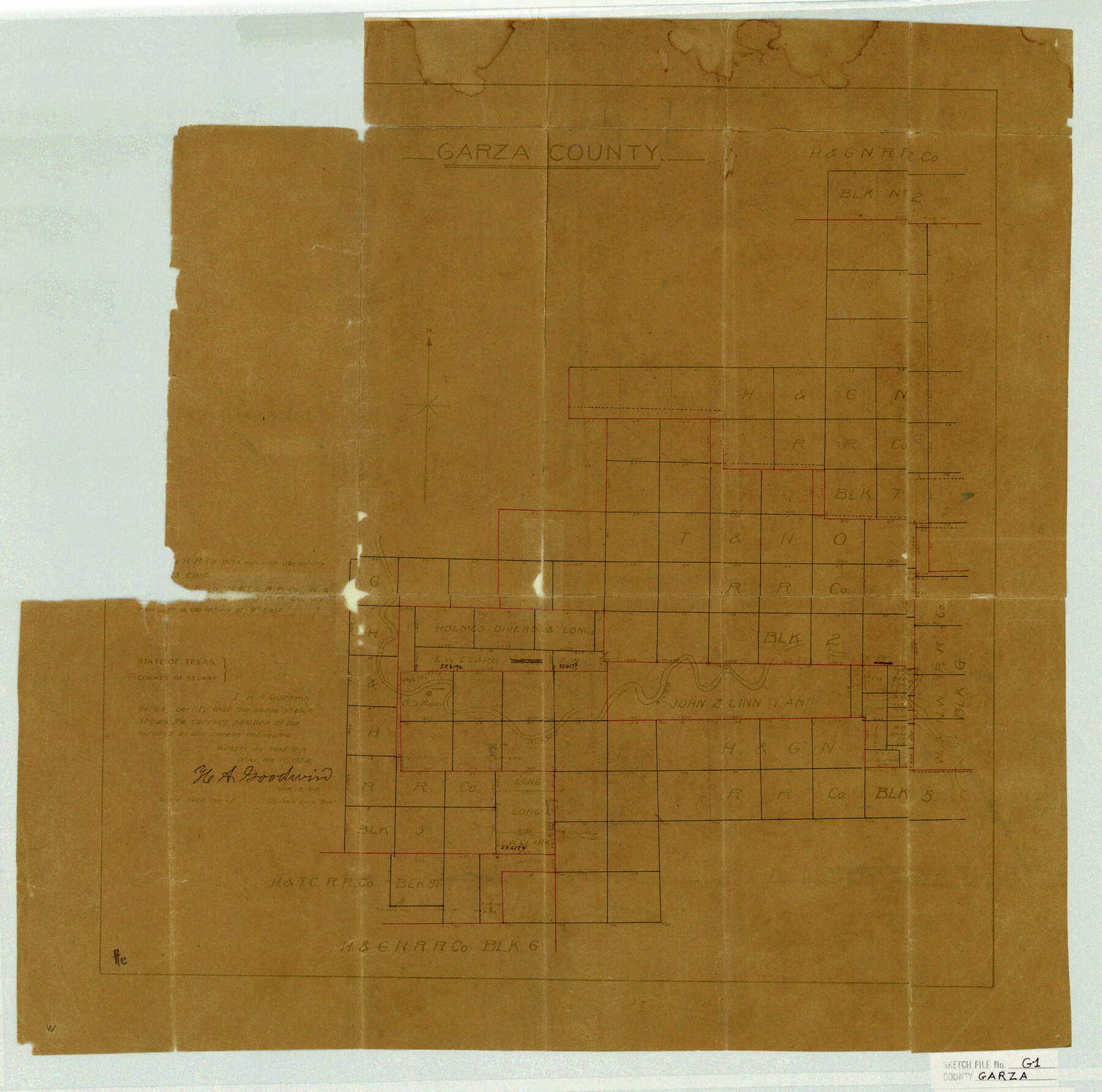
Garza County Sketch File G-1
Sketch of H. A. Goodwin, Dist. Surveyor of Scurry Land District Showing Surveys on Line of Garza & Kent Counties
-
Map/Doc
11554
-
Collection
General Map Collection
-
Object Dates
1904/5/17 (Creation Date)
1904/6/9 (File Date)
-
People and Organizations
Hugh A. Goodwin (Surveyor/Engineer)
-
Counties
Garza Kent
-
Subjects
Surveying Sketch File
-
Height x Width
20.4 x 20.6 inches
51.8 x 52.3 cm
-
Medium
paper, manuscript
-
Scale
1" = 2000 varas
-
Features
O.S. Ranch
Alamo River
Part of: General Map Collection
Flight Mission No. BRA-7M, Frame 186, Jefferson County

Print $20.00
- Digital $50.00
Flight Mission No. BRA-7M, Frame 186, Jefferson County
1953
Size 18.4 x 22.2 inches
Map/Doc 85554
Medina County Working Sketch 5

Print $20.00
- Digital $50.00
Medina County Working Sketch 5
1949
Size 38.5 x 37.3 inches
Map/Doc 70920
Flight Mission No. CRC-4R, Frame 93, Chambers County

Print $20.00
- Digital $50.00
Flight Mission No. CRC-4R, Frame 93, Chambers County
1956
Size 18.4 x 22.3 inches
Map/Doc 84890
San Saba County Working Sketch 4

Print $20.00
- Digital $50.00
San Saba County Working Sketch 4
1941
Size 43.4 x 31.8 inches
Map/Doc 63792
Gray County Working Sketch 1

Print $40.00
- Digital $50.00
Gray County Working Sketch 1
Size 121.0 x 38.8 inches
Map/Doc 63232
Concho County Working Sketch 19

Print $20.00
- Digital $50.00
Concho County Working Sketch 19
1957
Size 27.3 x 24.9 inches
Map/Doc 68201
South Sulphur River, Harpers Crossing Sheet

Print $20.00
- Digital $50.00
South Sulphur River, Harpers Crossing Sheet
1925
Size 23.3 x 18.0 inches
Map/Doc 78328
Jack County Sketch File 7

Print $6.00
- Digital $50.00
Jack County Sketch File 7
1857
Size 6.7 x 12.4 inches
Map/Doc 27516
Duval County Rolled Sketch 24

Print $20.00
- Digital $50.00
Duval County Rolled Sketch 24
1944
Size 24.5 x 42.3 inches
Map/Doc 5743
Wharton County Boundary File 1a

Print $12.00
- Digital $50.00
Wharton County Boundary File 1a
Size 11.7 x 9.2 inches
Map/Doc 59851
Wilbarger County Rolled Sketch 8

Print $20.00
- Digital $50.00
Wilbarger County Rolled Sketch 8
1965
Size 22.0 x 18.9 inches
Map/Doc 8257
Hall County Working Sketch 6

Print $20.00
- Digital $50.00
Hall County Working Sketch 6
1954
Size 21.8 x 21.6 inches
Map/Doc 63334
You may also like
Palo Pinto County, Texas

Print $20.00
- Digital $50.00
Palo Pinto County, Texas
1879
Size 17.8 x 19.0 inches
Map/Doc 529
Flight Mission No. CGI-3N, Frame 105, Cameron County

Print $20.00
- Digital $50.00
Flight Mission No. CGI-3N, Frame 105, Cameron County
1954
Size 18.5 x 22.2 inches
Map/Doc 84585
Real County Rolled Sketch 9

Print $20.00
- Digital $50.00
Real County Rolled Sketch 9
1967
Size 33.4 x 40.6 inches
Map/Doc 9834
Wharton County Rolled Sketch 13

Print $20.00
- Digital $50.00
Wharton County Rolled Sketch 13
1990
Size 22.4 x 28.1 inches
Map/Doc 8238
Ownership Map Hockley County, Texas

Print $20.00
- Digital $50.00
Ownership Map Hockley County, Texas
Size 19.1 x 20.4 inches
Map/Doc 92208
Lake Worth Boundary

Print $20.00
- Digital $50.00
Lake Worth Boundary
Size 19.5 x 33.4 inches
Map/Doc 62212
Right of Way and Track Map, The Missouri, Kansas and Texas Ry. of Texas operated by the Missouri, Kansas and Texas Ry. of Texas, Henrietta Division

Print $40.00
- Digital $50.00
Right of Way and Track Map, The Missouri, Kansas and Texas Ry. of Texas operated by the Missouri, Kansas and Texas Ry. of Texas, Henrietta Division
1918
Size 24.8 x 56.3 inches
Map/Doc 64069
Floyd County Boundary File 2

Print $53.00
- Digital $50.00
Floyd County Boundary File 2
Size 8.9 x 4.2 inches
Map/Doc 53462
Burnet County Boundary File 7a

Print $30.00
- Digital $50.00
Burnet County Boundary File 7a
Size 14.1 x 8.5 inches
Map/Doc 50902
Tom Green County Sketch File 15

Print $6.00
- Digital $50.00
Tom Green County Sketch File 15
1880
Size 13.3 x 10.9 inches
Map/Doc 38172
Kinney County Working Sketch 59

Print $20.00
- Digital $50.00
Kinney County Working Sketch 59
1999
Size 19.9 x 24.8 inches
Map/Doc 70241
Township 14 South Range 15 West of the Louisiana Meridian, Louisiana

Print $20.00
- Digital $50.00
Township 14 South Range 15 West of the Louisiana Meridian, Louisiana
1875
Size 19.6 x 24.6 inches
Map/Doc 65859