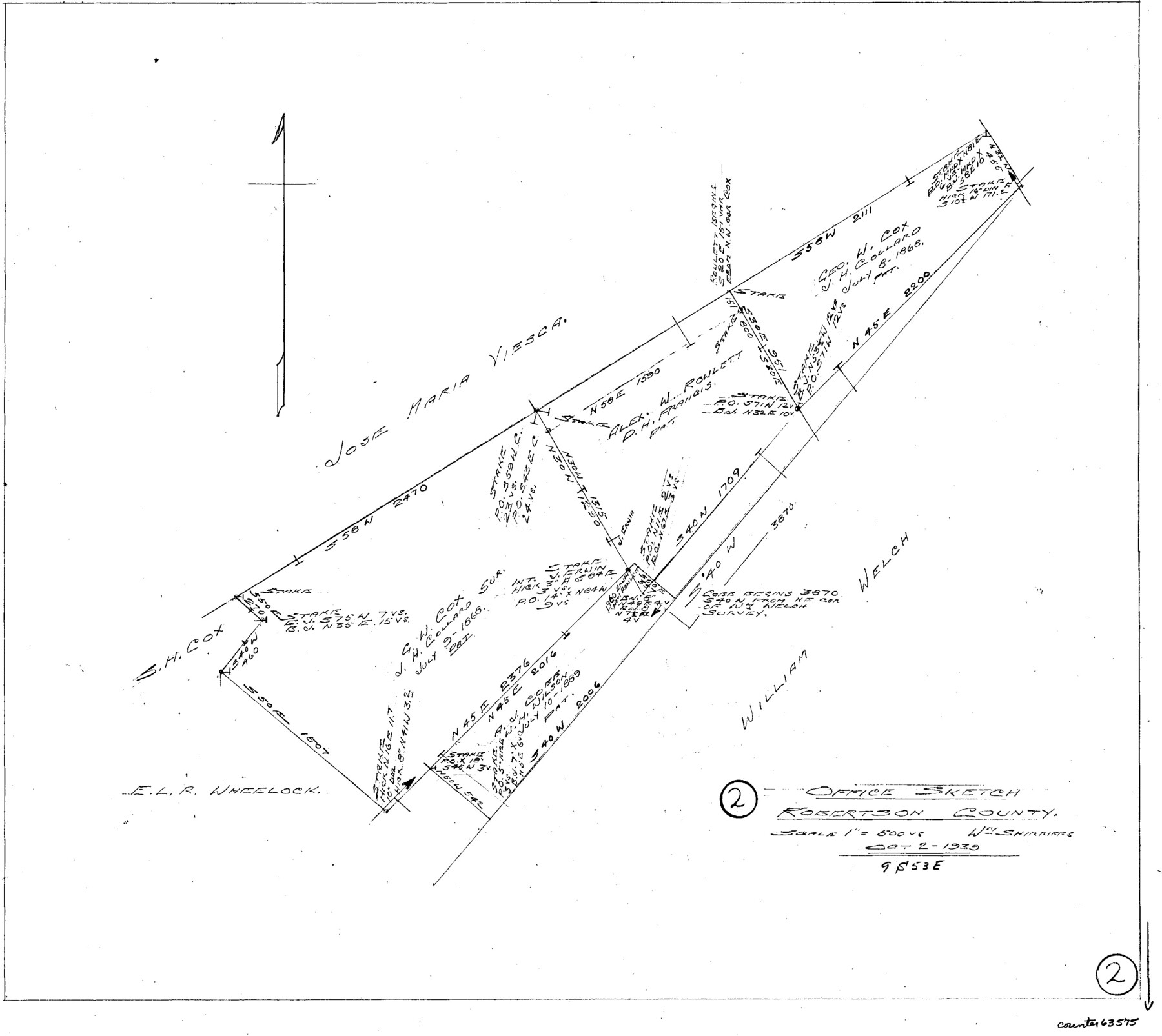
Robertson County Working Sketch 2
-
Map/Doc
63575
-
Collection
General Map Collection
-
Object Dates
10/2/1939 (Creation Date)
-
People and Organizations
William Shirriffs (Draftsman)
-
Counties
Robertson
-
Subjects
Surveying Working Sketch
-
Height x Width
14.5 x 16.3 inches
36.8 x 41.4 cm
-
Scale
1" = 500 varas
Part of: General Map Collection
Crosby County Sketch File 35

Print $4.00
- Digital $50.00
Crosby County Sketch File 35
Size 8.5 x 12.1 inches
Map/Doc 20106
Coke County Working Sketch 4

Print $20.00
- Digital $50.00
Coke County Working Sketch 4
1897
Size 15.6 x 16.4 inches
Map/Doc 68041
Sterling County Rolled Sketch 27

Print $20.00
- Digital $50.00
Sterling County Rolled Sketch 27
Size 24.0 x 23.2 inches
Map/Doc 7852
Edwards County Rolled Sketch 18

Print $20.00
- Digital $50.00
Edwards County Rolled Sketch 18
1947
Size 21.8 x 21.2 inches
Map/Doc 5807
Flight Mission No. DAG-28K, Frame 23, Matagorda County

Print $20.00
- Digital $50.00
Flight Mission No. DAG-28K, Frame 23, Matagorda County
1953
Size 18.6 x 22.5 inches
Map/Doc 86591
Travis County Sketch File 57

Print $8.00
- Digital $50.00
Travis County Sketch File 57
1947
Size 11.4 x 8.8 inches
Map/Doc 38402
Flight Mission No. DQN-5K, Frame 29, Calhoun County

Print $20.00
- Digital $50.00
Flight Mission No. DQN-5K, Frame 29, Calhoun County
1953
Size 18.5 x 22.3 inches
Map/Doc 84380
Smith County Rolled Sketch 1

Print $20.00
- Digital $50.00
Smith County Rolled Sketch 1
Size 42.4 x 34.8 inches
Map/Doc 9932
[Texas Central Railway through Callahan County]
![64240, [Texas Central Railway through Callahan County], General Map Collection](https://historictexasmaps.com/wmedia_w700/maps/64240-1.tif.jpg)
Print $40.00
- Digital $50.00
[Texas Central Railway through Callahan County]
Size 24.6 x 86.3 inches
Map/Doc 64240
Dallas County Boundary File 9

Print $6.00
- Digital $50.00
Dallas County Boundary File 9
2008
Map/Doc 88850
Jefferson County Rolled Sketch 9

Print $20.00
- Digital $50.00
Jefferson County Rolled Sketch 9
Size 36.6 x 47.0 inches
Map/Doc 9276
Flight Mission No. DQO-2K, Frame 99, Galveston County

Print $20.00
- Digital $50.00
Flight Mission No. DQO-2K, Frame 99, Galveston County
1952
Size 18.8 x 22.5 inches
Map/Doc 85026
You may also like
Railroad Track Map, H&TCRRCo., Falls County, Texas

Print $4.00
- Digital $50.00
Railroad Track Map, H&TCRRCo., Falls County, Texas
1918
Size 11.6 x 18.6 inches
Map/Doc 62852
Frio County Rolled Sketch 5

Print $20.00
- Digital $50.00
Frio County Rolled Sketch 5
Size 25.7 x 23.0 inches
Map/Doc 5917
Briscoe County Rolled Sketch 18

Print $20.00
- Digital $50.00
Briscoe County Rolled Sketch 18
1946
Size 36.7 x 27.3 inches
Map/Doc 5332
Caldwell County Working Sketch 8

Print $20.00
- Digital $50.00
Caldwell County Working Sketch 8
1964
Size 29.1 x 22.8 inches
Map/Doc 67838
[H. & G. N. Block 1]
![90810, [H. & G. N. Block 1], Twichell Survey Records](https://historictexasmaps.com/wmedia_w700/maps/90810-2.tif.jpg)
Print $3.00
- Digital $50.00
[H. & G. N. Block 1]
Size 11.4 x 12.9 inches
Map/Doc 90810
Henderson County Sketch File 3

Print $4.00
- Digital $50.00
Henderson County Sketch File 3
1852
Size 10.3 x 8.4 inches
Map/Doc 26321
General Highway Map, Washington County, Texas

Print $20.00
General Highway Map, Washington County, Texas
1940
Size 18.4 x 25.0 inches
Map/Doc 79272
Scurry County Working Sketch 5

Print $40.00
- Digital $50.00
Scurry County Working Sketch 5
1950
Size 72.5 x 27.8 inches
Map/Doc 63834
Runnels County Sketch File 11

Print $8.00
Runnels County Sketch File 11
1883
Size 10.7 x 7.9 inches
Map/Doc 35452
Somervell County Sketch File 2

Print $20.00
- Digital $50.00
Somervell County Sketch File 2
1847
Size 21.8 x 16.7 inches
Map/Doc 12325
Flight Mission No. DCL-7C, Frame 118, Kenedy County

Print $20.00
- Digital $50.00
Flight Mission No. DCL-7C, Frame 118, Kenedy County
1943
Size 18.4 x 22.3 inches
Map/Doc 86083
Val Verde County Working Sketch 43

Print $20.00
- Digital $50.00
Val Verde County Working Sketch 43
1945
Size 39.3 x 37.2 inches
Map/Doc 72178