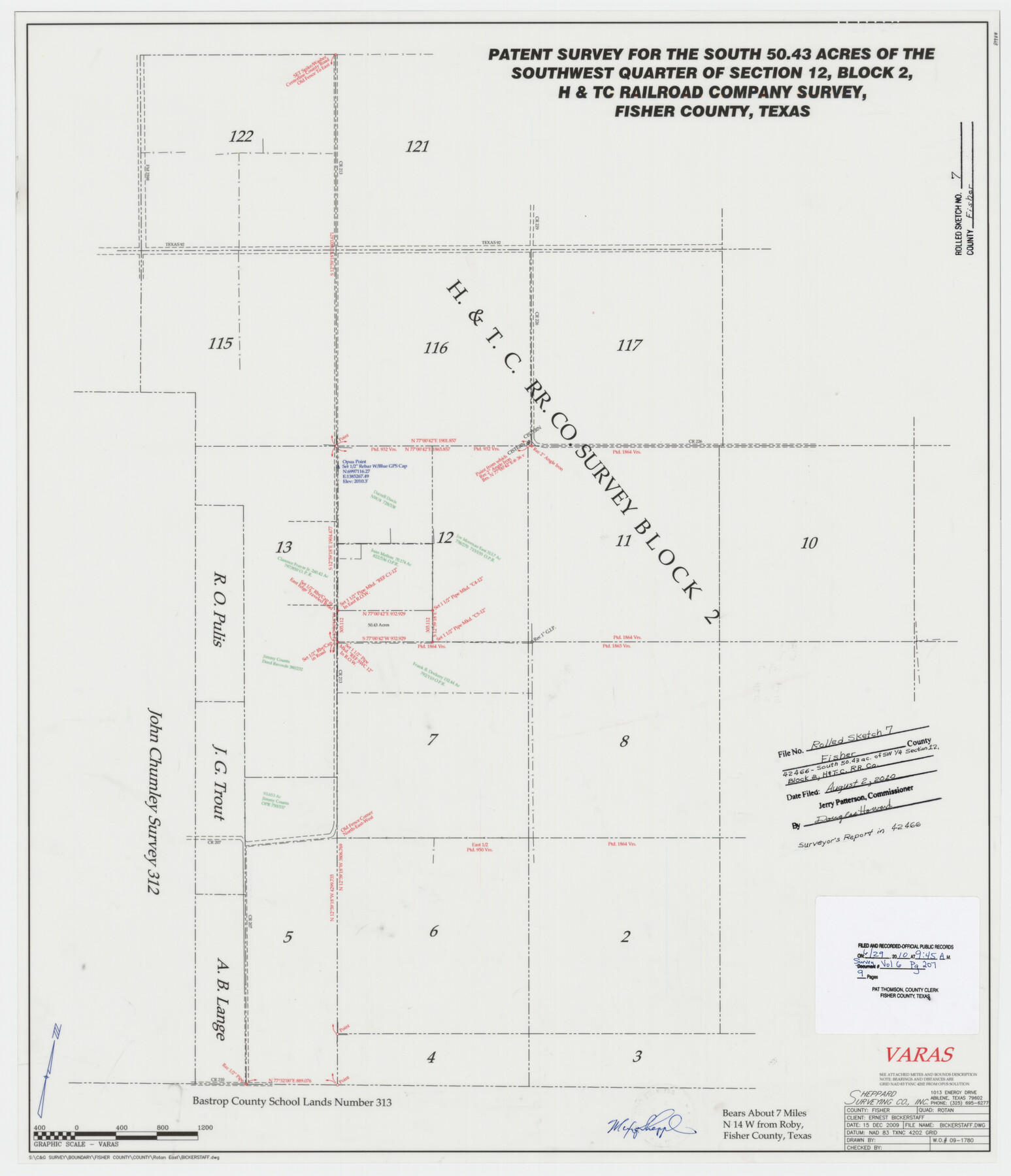
Fisher County Rolled Sketch 7
Patent survey for the south 50.43 acres of the southwest quarter of section 12, Block 2, H. & T. C. Railroad company survey, Fisher County, Texas
-
Map/Doc
89988
-
Collection
General Map Collection
-
Object Dates
2009/12/15 (Creation Date)
2010/8/2 (File Date)
-
People and Organizations
Maxey Sheppard (Surveyor/Engineer)
-
Counties
Fisher
-
Subjects
Surveying Rolled Sketch
-
Height x Width
28.6 x 24.6 inches
72.6 x 62.5 cm
-
Medium
mylar, print
-
Comments
Surveyor's report in School File 42466
Part of: General Map Collection
Nueces County Rolled Sketch 114

Print $20.00
- Digital $50.00
Nueces County Rolled Sketch 114
1992
Size 18.1 x 24.6 inches
Map/Doc 7125
Ochiltree County Sketch File A

Print $22.00
- Digital $50.00
Ochiltree County Sketch File A
1888
Size 8.7 x 5.7 inches
Map/Doc 33167
Harris County Aerial Photograph Index Sheet 9

Print $20.00
- Digital $50.00
Harris County Aerial Photograph Index Sheet 9
1953
Size 22.1 x 16.6 inches
Map/Doc 83703
Refugio County Boundary File 3

Print $4.00
- Digital $50.00
Refugio County Boundary File 3
Size 14.0 x 8.7 inches
Map/Doc 58244
Fort Bend County Sketch File 18 1/2

Print $20.00
- Digital $50.00
Fort Bend County Sketch File 18 1/2
1896
Size 18.3 x 15.3 inches
Map/Doc 11508
[Texas & Pacific Railway, Longview to Dallas]
![64098, [Texas & Pacific Railway, Longview to Dallas], General Map Collection](https://historictexasmaps.com/wmedia_w700/maps/64098.tif.jpg)
Print $40.00
- Digital $50.00
[Texas & Pacific Railway, Longview to Dallas]
1873
Size 14.5 x 121.6 inches
Map/Doc 64098
Travis County Working Sketch 45

Print $20.00
- Digital $50.00
Travis County Working Sketch 45
1975
Size 33.6 x 28.7 inches
Map/Doc 69429
El Paso County Boundary File 22

Print $4.00
- Digital $50.00
El Paso County Boundary File 22
Size 13.6 x 8.6 inches
Map/Doc 53216
Culberson County Sketch File 8

Print $40.00
- Digital $50.00
Culberson County Sketch File 8
1904
Size 13.2 x 14.6 inches
Map/Doc 20142
Flight Mission No. DIX-6P, Frame 194, Aransas County

Print $20.00
- Digital $50.00
Flight Mission No. DIX-6P, Frame 194, Aransas County
1956
Size 19.2 x 22.7 inches
Map/Doc 83856

Reeves County Rolled Sketch 39

Print $20.00
- Digital $50.00
Reeves County Rolled Sketch 39
2018
Size 25.0 x 36.5 inches
Map/Doc 96570
You may also like
Nueces County Rolled Sketch 56

Print $53.00
- Digital $50.00
Nueces County Rolled Sketch 56
1978
Size 10.0 x 15.1 inches
Map/Doc 47890
Karnes County Working Sketch 10

Print $20.00
- Digital $50.00
Karnes County Working Sketch 10
1970
Size 35.5 x 26.3 inches
Map/Doc 66658
Motley County Working Sketch 6

Print $20.00
- Digital $50.00
Motley County Working Sketch 6
1963
Size 17.6 x 29.3 inches
Map/Doc 71211
United States - Gulf Coast - From Latitude 26° 33' to the Rio Grande Texas

Print $20.00
- Digital $50.00
United States - Gulf Coast - From Latitude 26° 33' to the Rio Grande Texas
1913
Size 18.3 x 23.6 inches
Map/Doc 72843
Flight Mission No. DCL-6C, Frame 113, Kenedy County

Print $20.00
- Digital $50.00
Flight Mission No. DCL-6C, Frame 113, Kenedy County
1943
Size 15.5 x 15.3 inches
Map/Doc 85943
Hockley County Sketch File 15

Print $6.00
- Digital $50.00
Hockley County Sketch File 15
1912
Size 11.4 x 8.9 inches
Map/Doc 26550
Rains County Working Sketch 10

Print $20.00
- Digital $50.00
Rains County Working Sketch 10
1998
Size 36.1 x 34.7 inches
Map/Doc 71836
Terry County Sketch File 2

Print $8.00
- Digital $50.00
Terry County Sketch File 2
Size 8.9 x 11.4 inches
Map/Doc 38012
Victoria County Sketch File 8

Print $2.00
- Digital $50.00
Victoria County Sketch File 8
Size 5.7 x 5.6 inches
Map/Doc 39524
PSL Field Notes for Block CS in Dallam County

PSL Field Notes for Block CS in Dallam County
Map/Doc 81649
Palo Pinto County Working Sketch 16

Print $20.00
- Digital $50.00
Palo Pinto County Working Sketch 16
1974
Size 35.5 x 42.4 inches
Map/Doc 71399
Ochiltree County, Texas

Print $20.00
- Digital $50.00
Ochiltree County, Texas
1870
Size 21.4 x 19.7 inches
Map/Doc 507