El Paso County Boundary File 22
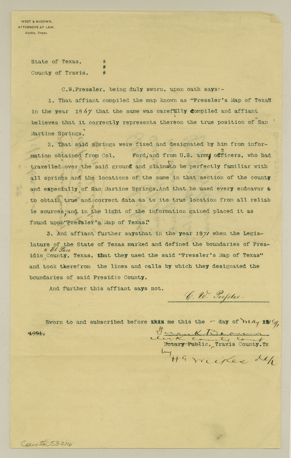
Jeff Davis v. Presidio County affidavit of C. W. Pressler
-
Map/Doc
53216
-
Collection
General Map Collection
-
Counties
El Paso
-
Subjects
County Boundaries
-
Height x Width
13.6 x 8.6 inches
34.5 x 21.8 cm
Part of: General Map Collection
Hardin County Rolled Sketch 12

Print $20.00
- Digital $50.00
Hardin County Rolled Sketch 12
1949
Size 36.3 x 47.3 inches
Map/Doc 10200
Colorado County Working Sketch 9

Print $20.00
- Digital $50.00
Colorado County Working Sketch 9
1939
Size 12.0 x 15.7 inches
Map/Doc 68109
Newton County Working Sketch 1

Print $20.00
- Digital $50.00
Newton County Working Sketch 1
Size 25.5 x 25.9 inches
Map/Doc 71247
Current Miscellaneous File 17

Print $24.00
- Digital $50.00
Current Miscellaneous File 17
1951
Size 10.7 x 8.1 inches
Map/Doc 73838
Pecos County Sketch File 66

Print $40.00
- Digital $50.00
Pecos County Sketch File 66
Size 14.3 x 16.2 inches
Map/Doc 33826
Brooks County Rolled Sketch 22

Print $20.00
- Digital $50.00
Brooks County Rolled Sketch 22
1943
Size 15.1 x 32.2 inches
Map/Doc 5343
Lighthouse establishment on the Atlantic and Gulf Coasts and coast signal stations

Print $20.00
- Digital $50.00
Lighthouse establishment on the Atlantic and Gulf Coasts and coast signal stations
1898
Size 25.1 x 18.3 inches
Map/Doc 73051
Maverick County Working Sketch 19

Print $40.00
- Digital $50.00
Maverick County Working Sketch 19
1975
Size 56.2 x 44.0 inches
Map/Doc 70911
Sutton County Working Sketch 13

Print $40.00
- Digital $50.00
Sutton County Working Sketch 13
1972
Size 58.8 x 37.0 inches
Map/Doc 62356
Pecos County Sketch File 120

Print $4.00
- Digital $50.00
Pecos County Sketch File 120
Size 14.3 x 8.7 inches
Map/Doc 34114
Jefferson County Sketch File 15

Print $10.00
- Digital $50.00
Jefferson County Sketch File 15
1870
Size 8.6 x 7.6 inches
Map/Doc 28151
Duval County Working Sketch 6

Print $20.00
- Digital $50.00
Duval County Working Sketch 6
1935
Size 26.9 x 21.8 inches
Map/Doc 68719
You may also like
Chambers County Sketch File 22

Print $8.00
- Digital $50.00
Chambers County Sketch File 22
Size 12.2 x 7.6 inches
Map/Doc 17594
Fannin County Working Sketch 10

Print $20.00
- Digital $50.00
Fannin County Working Sketch 10
1989
Size 26.5 x 38.0 inches
Map/Doc 69164
[Sketch of sections 59-64, I. & G. N. Block 1 and part of Block Z]
![93167, [Sketch of sections 59-64, I. & G. N. Block 1 and part of Block Z], Twichell Survey Records](https://historictexasmaps.com/wmedia_w700/maps/93167-1.tif.jpg)
Print $40.00
- Digital $50.00
[Sketch of sections 59-64, I. & G. N. Block 1 and part of Block Z]
Size 74.8 x 43.5 inches
Map/Doc 93167
Briscoe County Sketch File G

Print $40.00
- Digital $50.00
Briscoe County Sketch File G
1918
Size 17.7 x 22.4 inches
Map/Doc 11004
Crockett County Rolled Sketch 87

Print $20.00
- Digital $50.00
Crockett County Rolled Sketch 87
1967
Size 34.9 x 39.2 inches
Map/Doc 8726
Refugio County Sketch File 2

Print $6.00
- Digital $50.00
Refugio County Sketch File 2
1846
Size 12.6 x 7.7 inches
Map/Doc 35238
Flight Mission No. BQR-13K, Frame 21, Brazoria County

Print $20.00
- Digital $50.00
Flight Mission No. BQR-13K, Frame 21, Brazoria County
1952
Size 18.8 x 22.4 inches
Map/Doc 84069
Flight Mission No. DAG-17K, Frame 135, Matagorda County

Print $20.00
- Digital $50.00
Flight Mission No. DAG-17K, Frame 135, Matagorda County
1952
Size 17.4 x 16.1 inches
Map/Doc 86352
Calhoun County Rolled Sketch 8

Print $40.00
- Digital $50.00
Calhoun County Rolled Sketch 8
1921
Size 25.6 x 53.4 inches
Map/Doc 5364
Pecos County Rolled Sketch ANL

Print $20.00
- Digital $50.00
Pecos County Rolled Sketch ANL
Size 31.5 x 38.4 inches
Map/Doc 7308
Texas, Matagorda Bay, Vicinity of Carancahua Bay

Print $40.00
- Digital $50.00
Texas, Matagorda Bay, Vicinity of Carancahua Bay
1933
Size 30.3 x 48.2 inches
Map/Doc 69989
Sterling County Rolled Sketch 24

Print $20.00
- Digital $50.00
Sterling County Rolled Sketch 24
Size 25.8 x 19.6 inches
Map/Doc 7850