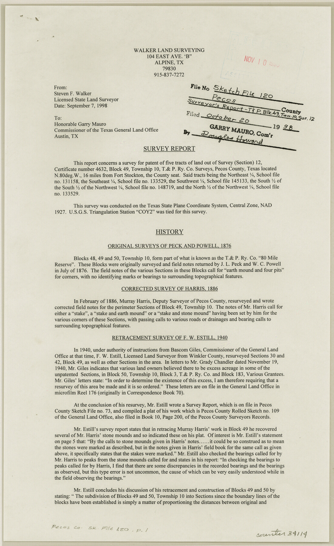
Pecos County Sketch File 120
[Survey report of T. & P. section 12, Block 49, Township 10]
-
Map/Doc
34114
-
Collection
General Map Collection
-
Object Dates
1998/10/20 (File Date)
1998/9/7 (Correspondence Date)
1886 (Survey Date)
1940 (Survey Date)
-
People and Organizations
Steven F. Walker (Surveyor/Engineer)
J.L. Peck (Surveyor/Engineer)
W.C. Powell (Surveyor/Engineer)
Murray Harris (Surveyor/Engineer)
F.W. Estill (Surveyor/Engineer)
-
Counties
Pecos
-
Subjects
Surveying Sketch File
-
Height x Width
14.3 x 8.7 inches
36.3 x 22.1 cm
-
Medium
paper, print
-
Comments
See Pecos County Rolled Sketch 189 (7307) for sketch.
-
Features
Coyanosa Draw
Related maps
Pecos County Rolled Sketch 189

Print $20.00
- Digital $50.00
Pecos County Rolled Sketch 189
1998
Size 22.2 x 33.7 inches
Map/Doc 7307
Part of: General Map Collection
Atascosa County

Print $20.00
- Digital $50.00
Atascosa County
1948
Size 47.6 x 44.9 inches
Map/Doc 77204
Intracoastal Waterway in Texas - Corpus Christi to Point Isabel including Arroyo Colorado to Mo. Pac. R.R. Bridge Near Harlingen

Print $20.00
- Digital $50.00
Intracoastal Waterway in Texas - Corpus Christi to Point Isabel including Arroyo Colorado to Mo. Pac. R.R. Bridge Near Harlingen
1934
Size 21.9 x 33.5 inches
Map/Doc 61882
[Texas Gulf Coast from Rio Grande to Sabine Lake]
![72687, [Texas Gulf Coast from Rio Grande to Sabine Lake], General Map Collection](https://historictexasmaps.com/wmedia_w700/maps/72687.tif.jpg)
Print $20.00
- Digital $50.00
[Texas Gulf Coast from Rio Grande to Sabine Lake]
Size 28.1 x 18.3 inches
Map/Doc 72687
McCulloch County Working Sketch 15

Print $20.00
- Digital $50.00
McCulloch County Working Sketch 15
1994
Size 33.2 x 34.0 inches
Map/Doc 70690
Edwards County Working Sketch 120

Print $40.00
- Digital $50.00
Edwards County Working Sketch 120
1975
Size 25.0 x 48.9 inches
Map/Doc 68996
Flight Mission No. DQN-2K, Frame 37, Calhoun County

Print $20.00
- Digital $50.00
Flight Mission No. DQN-2K, Frame 37, Calhoun County
1953
Size 18.4 x 22.2 inches
Map/Doc 84242
Crockett County Sketch File 88

Print $3.00
- Digital $50.00
Crockett County Sketch File 88
1958
Size 19.3 x 15.8 inches
Map/Doc 11237
Matagorda County Aerial Photograph Index Sheet 5

Print $20.00
- Digital $50.00
Matagorda County Aerial Photograph Index Sheet 5
1953
Size 23.6 x 19.5 inches
Map/Doc 83726
Dimmit County Working Sketch 16

Print $20.00
- Digital $50.00
Dimmit County Working Sketch 16
1943
Size 25.6 x 24.8 inches
Map/Doc 68677
Bandera County Boundary File 7

Print $14.00
- Digital $50.00
Bandera County Boundary File 7
Size 12.7 x 8.1 inches
Map/Doc 50306
Galveston County Rolled Sketch 27A

Print $20.00
- Digital $50.00
Galveston County Rolled Sketch 27A
1978
Size 32.2 x 35.5 inches
Map/Doc 5962
San Jacinto County Sketch File A

Print $5.00
San Jacinto County Sketch File A
1895
Size 8.5 x 11.3 inches
Map/Doc 35716
You may also like
[Pacific & Santa Fe Railroad through Fort Stockton]
![64770, [Pacific & Santa Fe Railroad through Fort Stockton], General Map Collection](https://historictexasmaps.com/wmedia_w700/maps/64770.tif.jpg)
Print $20.00
- Digital $50.00
[Pacific & Santa Fe Railroad through Fort Stockton]
Size 18.4 x 20.5 inches
Map/Doc 64770
Concho, San Saba & Llano Valley Railway, Sterling City Branch, Texas. Right of Way and Track Map

Print $40.00
- Digital $50.00
Concho, San Saba & Llano Valley Railway, Sterling City Branch, Texas. Right of Way and Track Map
1910
Size 18.3 x 59.7 inches
Map/Doc 64439
Presidio County Rolled Sketch A-2

Print $20.00
- Digital $50.00
Presidio County Rolled Sketch A-2
1889
Size 36.9 x 43.9 inches
Map/Doc 9770
[Surveys along the Frio River at the confluence of the Sabinal River]
![78372, [Surveys along the Frio River at the confluence of the Sabinal River], General Map Collection](https://historictexasmaps.com/wmedia_w700/maps/78372.tif.jpg)
Print $2.00
- Digital $50.00
[Surveys along the Frio River at the confluence of the Sabinal River]
1845
Size 6.2 x 8.9 inches
Map/Doc 78372
[Sketch for Mineral Application 24072, San Jacinto River]
![65597, [Sketch for Mineral Application 24072, San Jacinto River], General Map Collection](https://historictexasmaps.com/wmedia_w700/maps/65597.tif.jpg)
Print $20.00
- Digital $50.00
[Sketch for Mineral Application 24072, San Jacinto River]
1929
Size 24.6 x 18.4 inches
Map/Doc 65597
Castro County Working Sketch 2

Print $20.00
- Digital $50.00
Castro County Working Sketch 2
Size 30.4 x 26.2 inches
Map/Doc 67897
General Highway Map, Leon County, Texas

Print $20.00
General Highway Map, Leon County, Texas
1961
Size 18.3 x 24.8 inches
Map/Doc 79568
Lampasas County Sketch File 5

Print $8.00
- Digital $50.00
Lampasas County Sketch File 5
1869
Size 12.8 x 7.9 inches
Map/Doc 29396
[East line of Childress County along border of Oklahoma]
![91988, [East line of Childress County along border of Oklahoma], Twichell Survey Records](https://historictexasmaps.com/wmedia_w700/maps/91988-1.tif.jpg)
Print $20.00
- Digital $50.00
[East line of Childress County along border of Oklahoma]
Size 30.1 x 8.6 inches
Map/Doc 91988
Flight Mission No. CUG-3P, Frame 90, Kleberg County

Print $20.00
- Digital $50.00
Flight Mission No. CUG-3P, Frame 90, Kleberg County
1956
Size 18.6 x 22.3 inches
Map/Doc 86260
Flight Mission No. CUG-1P, Frame 27, Kleberg County

Print $20.00
- Digital $50.00
Flight Mission No. CUG-1P, Frame 27, Kleberg County
1956
Size 18.4 x 22.1 inches
Map/Doc 86117
Brewster County Rolled Sketch 123

Print $25.00
- Digital $50.00
Brewster County Rolled Sketch 123
Size 10.1 x 15.3 inches
Map/Doc 43129