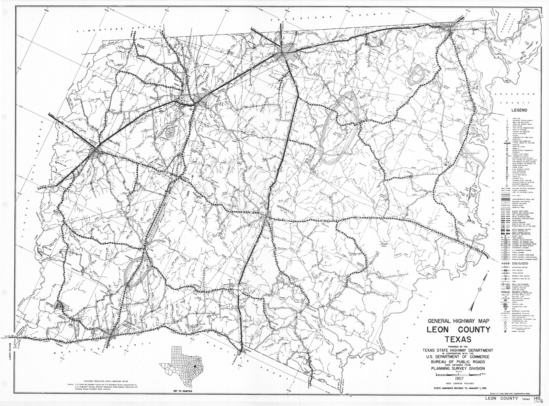
General Highway Map, Leon County, Texas
-
Map/Doc
79568
-
Collection
Texas State Library and Archives
-
Object Dates
1961 (Creation Date)
-
People and Organizations
Texas State Highway Department (Publisher)
-
Counties
Leon
-
Subjects
County
-
Height x Width
18.3 x 24.8 inches
46.5 x 63.0 cm
-
Comments
Prints available courtesy of the Texas State Library and Archives.
More info can be found here: TSLAC Map 05215
Part of: Texas State Library and Archives
General Highway Map. Detail of Cities and Towns in Val Verde County, Texas [Del Rio and vicinity]
![79695, General Highway Map. Detail of Cities and Towns in Val Verde County, Texas [Del Rio and vicinity], Texas State Library and Archives](https://historictexasmaps.com/wmedia_w700/maps/79695.tif.jpg)
Print $20.00
General Highway Map. Detail of Cities and Towns in Val Verde County, Texas [Del Rio and vicinity]
1961
Size 18.0 x 24.8 inches
Map/Doc 79695
General Highway Map, Webb County, Texas

Print $20.00
General Highway Map, Webb County, Texas
1961
Size 18.2 x 24.8 inches
Map/Doc 79704
Railroad and County Map of Texas

Print $20.00
Railroad and County Map of Texas
1901
Size 33.1 x 37.1 inches
Map/Doc 76213
General Highway Map, Zapata County, Texas

Print $20.00
General Highway Map, Zapata County, Texas
1961
Size 18.2 x 24.8 inches
Map/Doc 79721
General Highway Map, Hemphill County, Texas

Print $20.00
General Highway Map, Hemphill County, Texas
1940
Size 18.2 x 24.8 inches
Map/Doc 79124
General Highway Map, Navarro County, Texas

Print $20.00
General Highway Map, Navarro County, Texas
1939
Size 24.7 x 18.4 inches
Map/Doc 79206
General Highway Map, McCulloch County, Texas

Print $20.00
General Highway Map, McCulloch County, Texas
1940
Size 24.6 x 18.2 inches
Map/Doc 79190
Map of the City of San Antonio

Print $20.00
Map of the City of San Antonio
1909
Size 28.3 x 28.6 inches
Map/Doc 76293
General Highway Map. Detail of Cities of Towns in Bosque County, Texas

Print $20.00
General Highway Map. Detail of Cities of Towns in Bosque County, Texas
1961
Size 18.2 x 24.9 inches
Map/Doc 79379
General Highway Map, Navarro County, Texas

Print $20.00
General Highway Map, Navarro County, Texas
1939
Size 24.6 x 18.5 inches
Map/Doc 79207
General Highway Map, Johnson County, Texas

Print $20.00
General Highway Map, Johnson County, Texas
1961
Size 18.2 x 24.8 inches
Map/Doc 79545
Pressler's Map of the State of Texas

Print $40.00
Pressler's Map of the State of Texas
1858
Size 48.0 x 52.5 inches
Map/Doc 76232
You may also like
[Unorganized County School Land Leagues 284 - 317]
![90856, [Unorganized County School Land Leagues 284 - 317], Twichell Survey Records](https://historictexasmaps.com/wmedia_w700/maps/90856-2.tif.jpg)
Print $20.00
- Digital $50.00
[Unorganized County School Land Leagues 284 - 317]
1902
Size 30.2 x 20.6 inches
Map/Doc 90856
[Sketch of Survey 9, Block Z3]
![93093, [Sketch of Survey 9, Block Z3], Twichell Survey Records](https://historictexasmaps.com/wmedia_w700/maps/93093-1.tif.jpg)
Print $2.00
- Digital $50.00
[Sketch of Survey 9, Block Z3]
Size 7.6 x 6.6 inches
Map/Doc 93093
Panola County Working Sketch 35

Print $40.00
- Digital $50.00
Panola County Working Sketch 35
1983
Map/Doc 71444
Galveston County Sketch File 55

Print $20.00
- Digital $50.00
Galveston County Sketch File 55
1839
Size 5.2 x 3.7 inches
Map/Doc 23591
A Map of Louisiana and Mexico

Print $20.00
A Map of Louisiana and Mexico
1820
Size 43.0 x 32.6 inches
Map/Doc 76218
Gray County Sketch File 7c

Print $20.00
- Digital $50.00
Gray County Sketch File 7c
1885
Size 26.5 x 19.6 inches
Map/Doc 11576
Houston Ship Channel, Alexander Island to Carpenter Bayou

Print $40.00
- Digital $50.00
Houston Ship Channel, Alexander Island to Carpenter Bayou
1992
Size 35.3 x 49.3 inches
Map/Doc 69917
Armstrong County Sketch File 9

Print $12.00
- Digital $50.00
Armstrong County Sketch File 9
1904
Size 11.6 x 9.1 inches
Map/Doc 41460
Crane County Sketch File 7

Print $6.00
- Digital $50.00
Crane County Sketch File 7
1886
Size 10.3 x 11.0 inches
Map/Doc 19567
[Map of Connecting Lines along or near the Red River]
![75546, [Map of Connecting Lines along or near the Red River], General Map Collection](https://historictexasmaps.com/wmedia_w700/maps/75546.tif.jpg)
Print $20.00
- Digital $50.00
[Map of Connecting Lines along or near the Red River]
Size 28.6 x 37.0 inches
Map/Doc 75546
Llano County Working Sketch 14

Print $20.00
- Digital $50.00
Llano County Working Sketch 14
1989
Size 14.6 x 34.7 inches
Map/Doc 70632
Edwards County Sketch File 9

Print $20.00
- Digital $50.00
Edwards County Sketch File 9
Size 16.9 x 37.8 inches
Map/Doc 10443