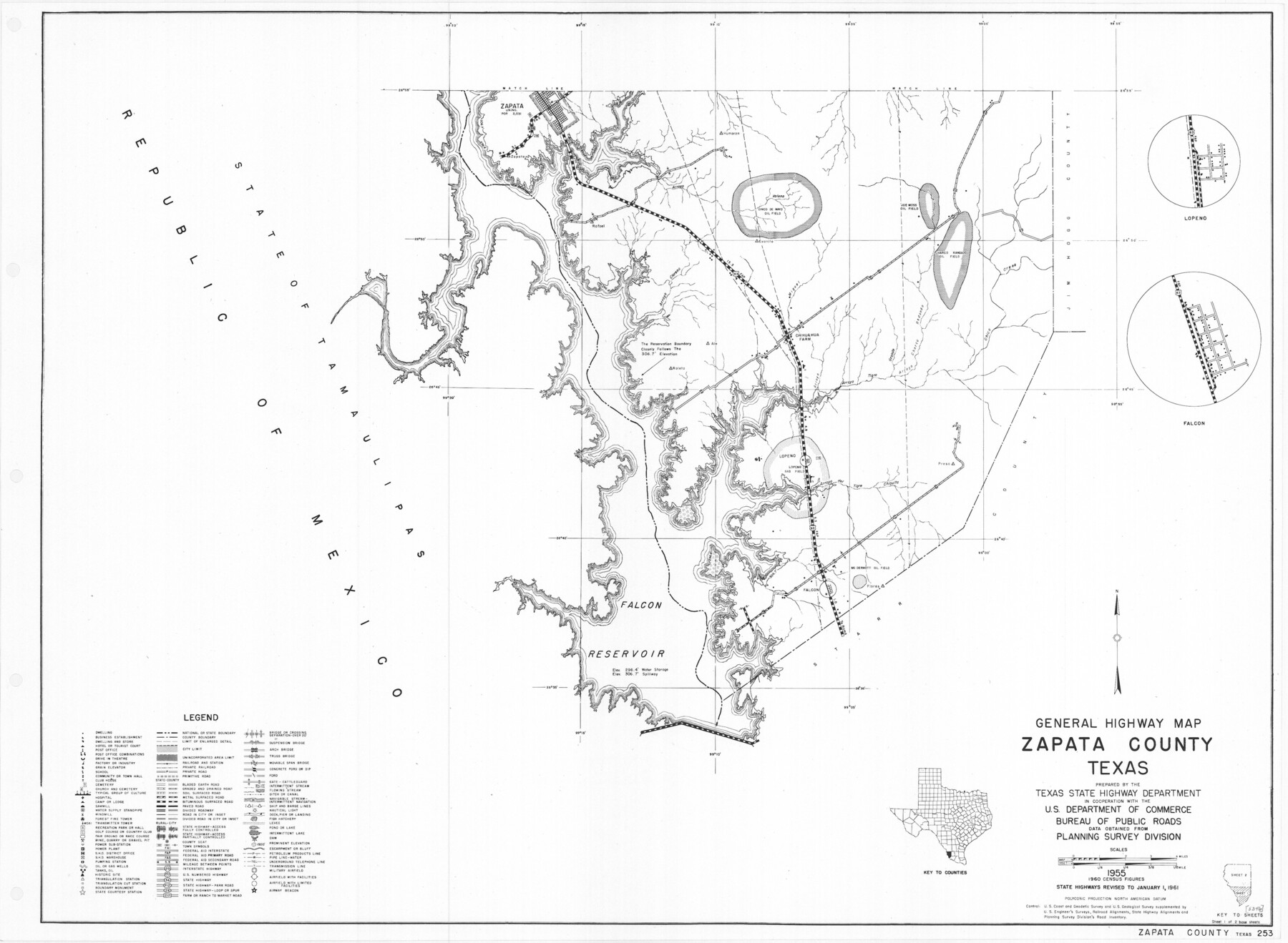
General Highway Map, Zapata County, Texas
-
Map/Doc
79721
-
Collection
Texas State Library and Archives
-
Object Dates
1961 (Creation Date)
-
People and Organizations
Texas State Highway Department (Publisher)
-
Counties
Zapata
-
Subjects
County
-
Height x Width
18.2 x 24.8 inches
46.2 x 63.0 cm
-
Comments
Prints available courtesy of the Texas State Library and Archives.
More info can be found here: TSLAC Map 05346
Part of: Texas State Library and Archives
General Highway Map, Kerr County, Texas

Print $20.00
General Highway Map, Kerr County, Texas
1961
Size 24.8 x 18.2 inches
Map/Doc 79551
General Highway Map, Hays County, Texas

Print $20.00
General Highway Map, Hays County, Texas
1961
Size 18.1 x 24.7 inches
Map/Doc 79513
General Highway Map, Kinney County, Uvalde County, Texas

Print $20.00
General Highway Map, Kinney County, Uvalde County, Texas
1940
Size 18.4 x 24.8 inches
Map/Doc 79162
Rand McNally Standard Map of Texas

Print $20.00
Rand McNally Standard Map of Texas
1923
Size 27.7 x 40.3 inches
Map/Doc 76259
General Highway Map, Nueces County, Texas

Print $20.00
General Highway Map, Nueces County, Texas
1961
Size 24.6 x 18.2 inches
Map/Doc 79616
Pocket Map of the State of Texas reduced from their original map of the State and drawn by Chas. W. Pressler and A. B. Langermann

Print $20.00
Pocket Map of the State of Texas reduced from their original map of the State and drawn by Chas. W. Pressler and A. B. Langermann
1879
Size 24.4 x 26.3 inches
Map/Doc 76208
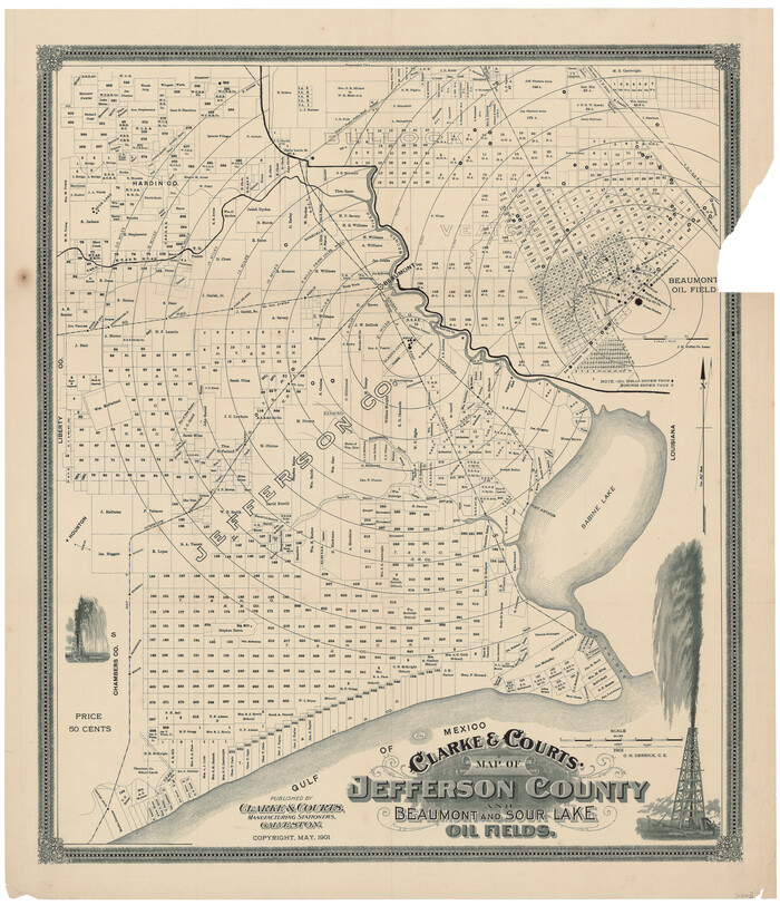
Clarke and Courts' Map of Jefferson County and Beaumont and Sour Lake Oil Fields
Print $20.00
Clarke and Courts' Map of Jefferson County and Beaumont and Sour Lake Oil Fields
1901
Size 28.2 x 24.3 inches
Map/Doc 79289
Clason's Guide Map Texas and Northern Mexico

Print $20.00
Clason's Guide Map Texas and Northern Mexico
1924
Size 21.3 x 28.4 inches
Map/Doc 76314
General Highway Map, Hudspeth County, Texas

Print $20.00
General Highway Map, Hudspeth County, Texas
1961
Size 25.1 x 18.2 inches
Map/Doc 79527
General Highway Map, Rusk County, Texas

Print $20.00
General Highway Map, Rusk County, Texas
1961
Size 24.9 x 18.2 inches
Map/Doc 79643
General Highway Map. Detail of Cities and Towns in Travis County, Texas. City Map, Austin and vicinity, Travis County, Texas

Print $20.00
General Highway Map. Detail of Cities and Towns in Travis County, Texas. City Map, Austin and vicinity, Travis County, Texas
1961
Size 18.2 x 24.9 inches
Map/Doc 79684
Oil and Gas Fields in the State of Texas

Print $40.00
Oil and Gas Fields in the State of Texas
1927
Size 58.2 x 38.1 inches
Map/Doc 76303
You may also like
Lipscomb County Sketch File 4

Print $56.00
- Digital $50.00
Lipscomb County Sketch File 4
1910
Size 11.2 x 8.7 inches
Map/Doc 30233
[Sketch fragment in Garza and Crosby Counties]
![90855, [Sketch fragment in Garza and Crosby Counties], Twichell Survey Records](https://historictexasmaps.com/wmedia_w700/maps/90855-2.tif.jpg)
Print $20.00
- Digital $50.00
[Sketch fragment in Garza and Crosby Counties]
Size 32.6 x 17.0 inches
Map/Doc 90855
Bee County Sketch File 8

Print $8.00
- Digital $50.00
Bee County Sketch File 8
1874
Size 12.4 x 8.0 inches
Map/Doc 14279
Nueces County Rolled Sketch 45

Print $20.00
- Digital $50.00
Nueces County Rolled Sketch 45
1941
Size 40.5 x 45.0 inches
Map/Doc 10295
Plat of the Resubdivision of the Abandoned Townsite of Eschiti, Oklahoma

Print $4.00
- Digital $50.00
Plat of the Resubdivision of the Abandoned Townsite of Eschiti, Oklahoma
1907
Size 18.1 x 24.3 inches
Map/Doc 75150
Hudspeth County Rolled Sketch 32

Print $40.00
- Digital $50.00
Hudspeth County Rolled Sketch 32
Size 32.7 x 94.9 inches
Map/Doc 9211

Flight Mission No. CGI-3N, Frame 71, Cameron County

Print $20.00
- Digital $50.00
Flight Mission No. CGI-3N, Frame 71, Cameron County
1954
Size 18.4 x 22.3 inches
Map/Doc 84565
The First Part of Captn. Pike's Chart of the Internal Part of Louisiana

Print $20.00
- Digital $50.00
The First Part of Captn. Pike's Chart of the Internal Part of Louisiana
1810
Size 19.6 x 21.2 inches
Map/Doc 95154
Fayette County Boundary File 4

Print $19.00
- Digital $50.00
Fayette County Boundary File 4
Size 14.4 x 9.0 inches
Map/Doc 53362
Montague County

Print $20.00
- Digital $50.00
Montague County
1875
Size 24.6 x 21.1 inches
Map/Doc 3884
Township No. 2 South Range No. 23 West of the Indian Meridian

Print $20.00
- Digital $50.00
Township No. 2 South Range No. 23 West of the Indian Meridian
1875
Size 19.3 x 24.4 inches
Map/Doc 75175