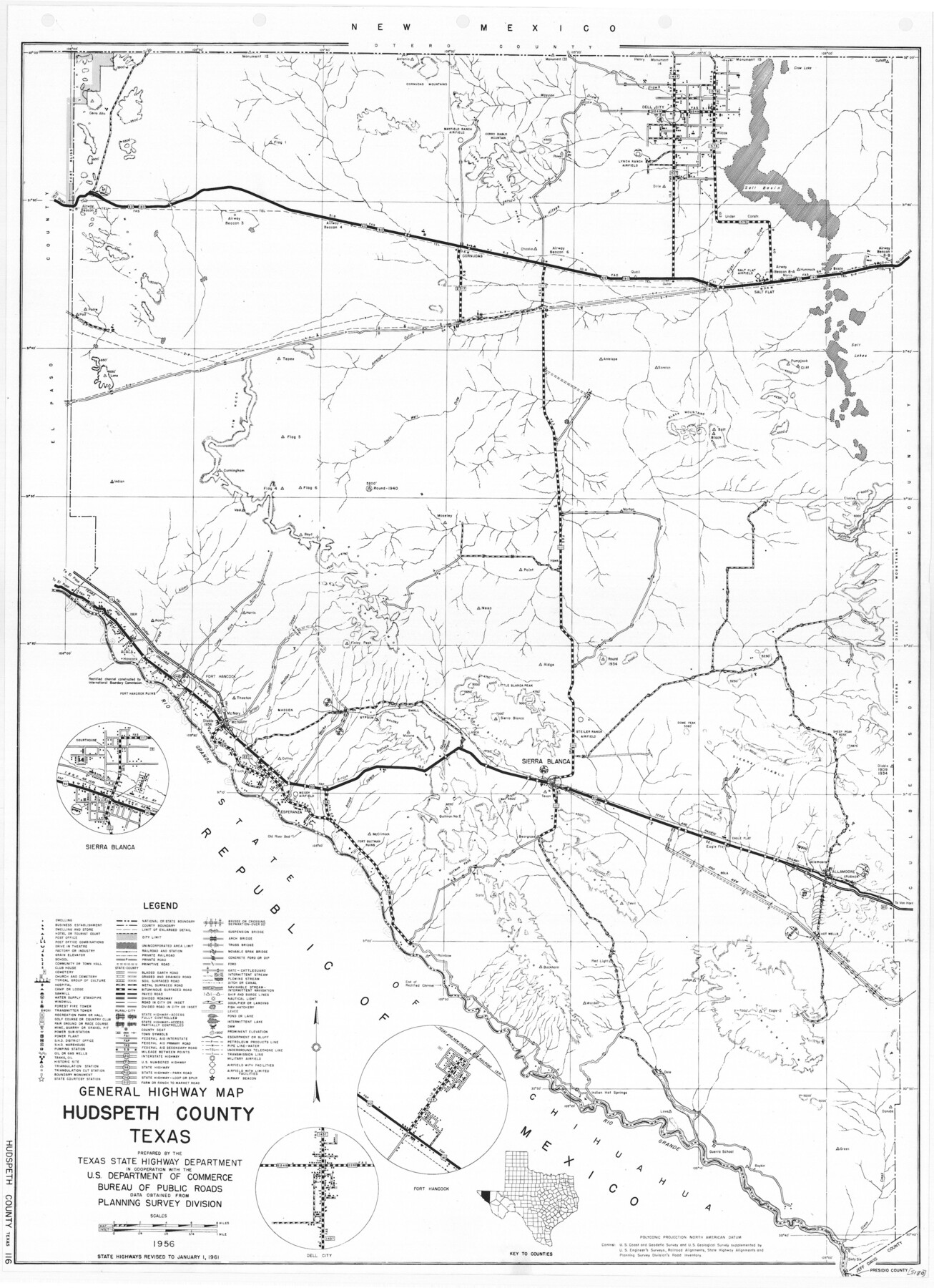
General Highway Map, Hudspeth County, Texas
-
Map/Doc
79527
-
Collection
Texas State Library and Archives
-
Object Dates
1961 (Creation Date)
-
People and Organizations
Texas State Highway Department (Publisher)
-
Counties
Hudspeth
-
Subjects
County
-
Height x Width
25.1 x 18.2 inches
63.8 x 46.2 cm
-
Comments
Prints available courtesy of the Texas State Library and Archives.
More info can be found here: TSLAC Map 05180
Part of: Texas State Library and Archives
General Highway Map, Wilbarger County, Texas

Print $20.00
General Highway Map, Wilbarger County, Texas
1961
Size 24.9 x 18.2 inches
Map/Doc 79710
General Highway Map, Brazoria County, Texas

Print $20.00
General Highway Map, Brazoria County, Texas
1961
Size 25.0 x 18.2 inches
Map/Doc 79382
General Highway Map, Duval County, Texas

Print $20.00
General Highway Map, Duval County, Texas
1961
Size 18.1 x 24.5 inches
Map/Doc 79449
General Highway Map, Haskell County, Texas

Print $20.00
General Highway Map, Haskell County, Texas
1940
Size 18.5 x 24.8 inches
Map/Doc 79122
General Highway Map. Detail of Cities and Towns in Harris County, Texas. City Map [of] Baytown, Morgan's Point, Lomax, and vicinity, Harris County, Texas
![79508, General Highway Map. Detail of Cities and Towns in Harris County, Texas. City Map [of] Baytown, Morgan's Point, Lomax, and vicinity, Harris County, Texas, Texas State Library and Archives](https://historictexasmaps.com/wmedia_w700/maps/79508.tif.jpg)
Print $20.00
General Highway Map. Detail of Cities and Towns in Harris County, Texas. City Map [of] Baytown, Morgan's Point, Lomax, and vicinity, Harris County, Texas
1961
Size 18.2 x 24.5 inches
Map/Doc 79508
Mapa de los Estados Unidos Mejicanos

Print $20.00
Mapa de los Estados Unidos Mejicanos
1831
Size 24.7 x 29.7 inches
Map/Doc 79291
Map Showing Proposed System of State Highways as Adopted June 1917

Print $20.00
Map Showing Proposed System of State Highways as Adopted June 1917
1917
Size 20.9 x 22.4 inches
Map/Doc 76294
Mitchell's Travellers Guide Through the United States. A Map of the Roads, Distances, Steam Boat, and Canal Routes etc.

Print $20.00
Mitchell's Travellers Guide Through the United States. A Map of the Roads, Distances, Steam Boat, and Canal Routes etc.
1834
Size 18.2 x 22.6 inches
Map/Doc 79314
Map of the United States and their Territories between the Mississippi and the Pacific Ocean and Part of Mexico

Print $20.00
Map of the United States and their Territories between the Mississippi and the Pacific Ocean and Part of Mexico
1857
Size 21.8 x 24.7 inches
Map/Doc 79724
General Highway Map. Detail of Cities and Towns in Harris County, Texas. City Map [of] Houston, Pasadena, West University Place, Bellaire, Galena Park, Jacinto City, South Houston, South Side Place, Deer Park, and vicinity, Harris County, Texas
![79505, General Highway Map. Detail of Cities and Towns in Harris County, Texas. City Map [of] Houston, Pasadena, West University Place, Bellaire, Galena Park, Jacinto City, South Houston, South Side Place, Deer Park, and vicinity, Harris County, Texas, Texas State Library and Archives](https://historictexasmaps.com/wmedia_w700/maps/79505.tif.jpg)
Print $20.00
General Highway Map. Detail of Cities and Towns in Harris County, Texas. City Map [of] Houston, Pasadena, West University Place, Bellaire, Galena Park, Jacinto City, South Houston, South Side Place, Deer Park, and vicinity, Harris County, Texas
1961
Size 18.0 x 25.0 inches
Map/Doc 79505
General Highway Map, Castro County, Texas

Print $20.00
General Highway Map, Castro County, Texas
1961
Size 18.2 x 24.7 inches
Map/Doc 79403
General Highway Map. Detail of Cities and Towns in Harris County, Texas

Print $20.00
General Highway Map. Detail of Cities and Towns in Harris County, Texas
1939
Size 18.2 x 24.9 inches
Map/Doc 79119
You may also like
Maps of Gulf Intracoastal Waterway, Texas - Sabine River to the Rio Grande and connecting waterways including ship channels

Print $20.00
- Digital $50.00
Maps of Gulf Intracoastal Waterway, Texas - Sabine River to the Rio Grande and connecting waterways including ship channels
1966
Size 14.6 x 20.7 inches
Map/Doc 61999
Hood County Working Sketch 4

Print $20.00
- Digital $50.00
Hood County Working Sketch 4
1967
Size 31.6 x 36.6 inches
Map/Doc 66198
Right of Way & Track Map, St. Louis, Brownsville & Mexico Ry. operated by St. Louis, Brownsville & Mexico Ry. Co.

Print $40.00
- Digital $50.00
Right of Way & Track Map, St. Louis, Brownsville & Mexico Ry. operated by St. Louis, Brownsville & Mexico Ry. Co.
1919
Size 25.6 x 57.1 inches
Map/Doc 64616
Texas Gulf Coast Map from the Sabine River to the Rio Grande as subdivided for mineral development

Print $40.00
- Digital $50.00
Texas Gulf Coast Map from the Sabine River to the Rio Grande as subdivided for mineral development
1948
Size 48.9 x 38.0 inches
Map/Doc 2910
[Map of Townsite of Swearingen, Cottle County, Texas]
![4465, [Map of Townsite of Swearingen, Cottle County, Texas], Maddox Collection](https://historictexasmaps.com/wmedia_w700/maps/4465.tif.jpg)
Print $20.00
- Digital $50.00
[Map of Townsite of Swearingen, Cottle County, Texas]
Size 28.8 x 17.8 inches
Map/Doc 4465
Orange County Sketch File 9

Print $20.00
- Digital $50.00
Orange County Sketch File 9
1874
Size 12.7 x 22.9 inches
Map/Doc 12117
Presidio County Sketch File 104

Print $17.00
- Digital $50.00
Presidio County Sketch File 104
Size 11.3 x 8.7 inches
Map/Doc 34807
Hudspeth County Rolled Sketch 78

Print $20.00
- Digital $50.00
Hudspeth County Rolled Sketch 78
2010
Size 18.4 x 24.5 inches
Map/Doc 93290
Atascosa County Rolled Sketch 4

Print $20.00
- Digital $50.00
Atascosa County Rolled Sketch 4
Size 21.0 x 15.8 inches
Map/Doc 5087
Geological map of Texas showing approximate locations and drilling wells. Also names of companies drilling

Print $20.00
- Digital $50.00
Geological map of Texas showing approximate locations and drilling wells. Also names of companies drilling
1920
Size 26.9 x 26.6 inches
Map/Doc 93937
Nueces County Sketch File 35

Print $2.00
- Digital $50.00
Nueces County Sketch File 35
1913
Size 13.1 x 4.8 inches
Map/Doc 32613
Limestone County Sketch File 6

Print $4.00
- Digital $50.00
Limestone County Sketch File 6
1859
Size 9.2 x 8.0 inches
Map/Doc 30167