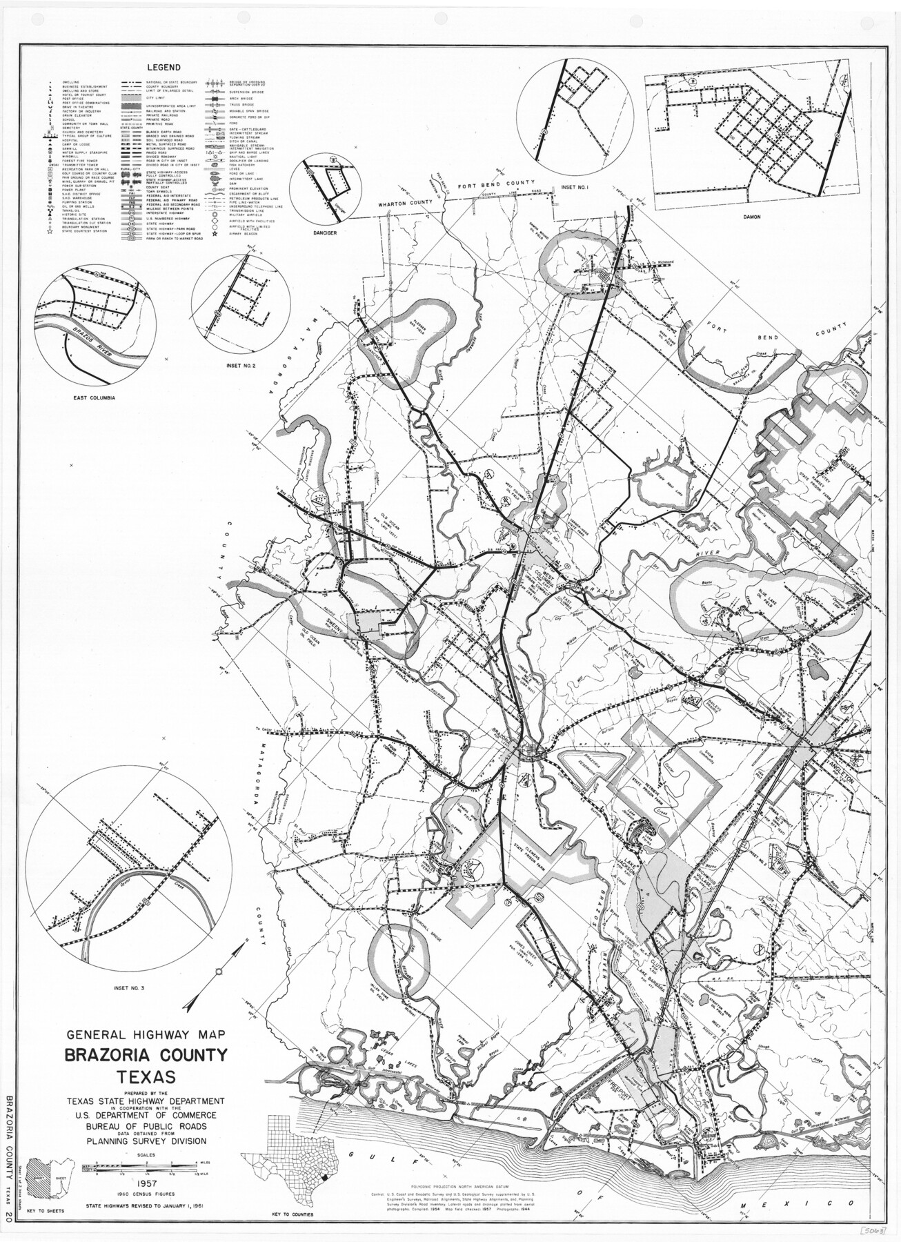
General Highway Map, Brazoria County, Texas
-
Map/Doc
79382
-
Collection
Texas State Library and Archives
-
Object Dates
1961 (Creation Date)
-
People and Organizations
Texas State Highway Department (Publisher)
-
Counties
Brazoria
-
Subjects
County
-
Height x Width
25.0 x 18.2 inches
63.5 x 46.2 cm
-
Comments
Prints available courtesy of the Texas State Library and Archives.
More info can be found here: TSLAC Map 05063
Part of: Texas State Library and Archives
General Highway Map, Brown County, Texas

Print $20.00
General Highway Map, Brown County, Texas
1940
Size 25.0 x 18.4 inches
Map/Doc 79031
General Highway Map, Hall County, Texas

Print $20.00
General Highway Map, Hall County, Texas
1961
Size 18.2 x 24.6 inches
Map/Doc 79495
General Highway Map, Lavaca County, Texas

Print $20.00
General Highway Map, Lavaca County, Texas
1940
Size 24.7 x 18.3 inches
Map/Doc 79170
General Highway Map, Gaines County, Texas

Print $20.00
General Highway Map, Gaines County, Texas
1961
Size 24.6 x 18.0 inches
Map/Doc 79475
General Highway Map Supplementary Sheet Showing Detail of Cities and Towns in Bexar County Texas

Print $20.00
General Highway Map Supplementary Sheet Showing Detail of Cities and Towns in Bexar County Texas
1936
Size 18.5 x 25.0 inches
Map/Doc 76290
Preliminary Chart of the Northwestern Part of the Gulf of Mexico

Print $20.00
Preliminary Chart of the Northwestern Part of the Gulf of Mexico
1855
Size 32.3 x 41.6 inches
Map/Doc 79334
General Highway Map, Brazoria County, Texas

Print $20.00
General Highway Map, Brazoria County, Texas
1939
Size 18.4 x 24.9 inches
Map/Doc 79025
General Highway Map, Terrell County, Texas

Print $20.00
General Highway Map, Terrell County, Texas
1940
Size 24.9 x 18.4 inches
Map/Doc 79256
Description of Best Route from San Antonio to Laredo, Texas

Print $20.00
Description of Best Route from San Antonio to Laredo, Texas
1865
Size 28.6 x 13.7 inches
Map/Doc 79302
Map of the County and City of Galveston, Texas

Print $20.00
Map of the County and City of Galveston, Texas
1891
Size 24.5 x 34.4 inches
Map/Doc 79290
General Highway Map, Matagorda County, Texas

Print $20.00
General Highway Map, Matagorda County, Texas
1939
Size 24.7 x 18.3 inches
Map/Doc 79187
General Highway Map, Gaines County, Texas

Print $20.00
General Highway Map, Gaines County, Texas
1961
Size 24.6 x 18.1 inches
Map/Doc 79474
You may also like
Pecos County Rolled Sketch 112

Print $20.00
- Digital $50.00
Pecos County Rolled Sketch 112
1941
Size 39.0 x 37.0 inches
Map/Doc 9720
Travis County Rolled Sketch 21

Print $20.00
- Digital $50.00
Travis County Rolled Sketch 21
1941
Size 16.2 x 14.7 inches
Map/Doc 8022

Capitol Syndicate Subdivision of Capitol Land Reservation Leagues

Print $20.00
- Digital $50.00
Capitol Syndicate Subdivision of Capitol Land Reservation Leagues
1908
Size 25.6 x 31.5 inches
Map/Doc 92584
Nueces County Sketch File 83

Print $63.00
- Digital $50.00
Nueces County Sketch File 83
1997
Size 11.1 x 8.5 inches
Map/Doc 43013
Fannin County Sketch File 16

Print $4.00
- Digital $50.00
Fannin County Sketch File 16
1873
Size 8.1 x 10.3 inches
Map/Doc 22469
Matagorda County Sketch File 24

Print $10.00
- Digital $50.00
Matagorda County Sketch File 24
1900
Size 8.2 x 5.1 inches
Map/Doc 30787
Yoakum County Rolled Sketch 1

Print $20.00
- Digital $50.00
Yoakum County Rolled Sketch 1
1939
Size 40.5 x 37.5 inches
Map/Doc 10162
Armstrong County Boundary File 3

Print $14.00
- Digital $50.00
Armstrong County Boundary File 3
Size 11.3 x 8.8 inches
Map/Doc 50141
Hudspeth County Sketch File 4b

Print $20.00
- Digital $50.00
Hudspeth County Sketch File 4b
1860
Size 13.0 x 39.2 inches
Map/Doc 10492
Atascosa County Sketch File 30

Print $18.00
- Digital $50.00
Atascosa County Sketch File 30
1900
Size 11.2 x 8.8 inches
Map/Doc 13816
[Surveys in the Milam District on Bosque River and Spring Creek]
![3170, [Surveys in the Milam District on Bosque River and Spring Creek], General Map Collection](https://historictexasmaps.com/wmedia_w700/maps/3170.tif.jpg)
Print $20.00
- Digital $50.00
[Surveys in the Milam District on Bosque River and Spring Creek]
1846
Size 13.3 x 14.7 inches
Map/Doc 3170