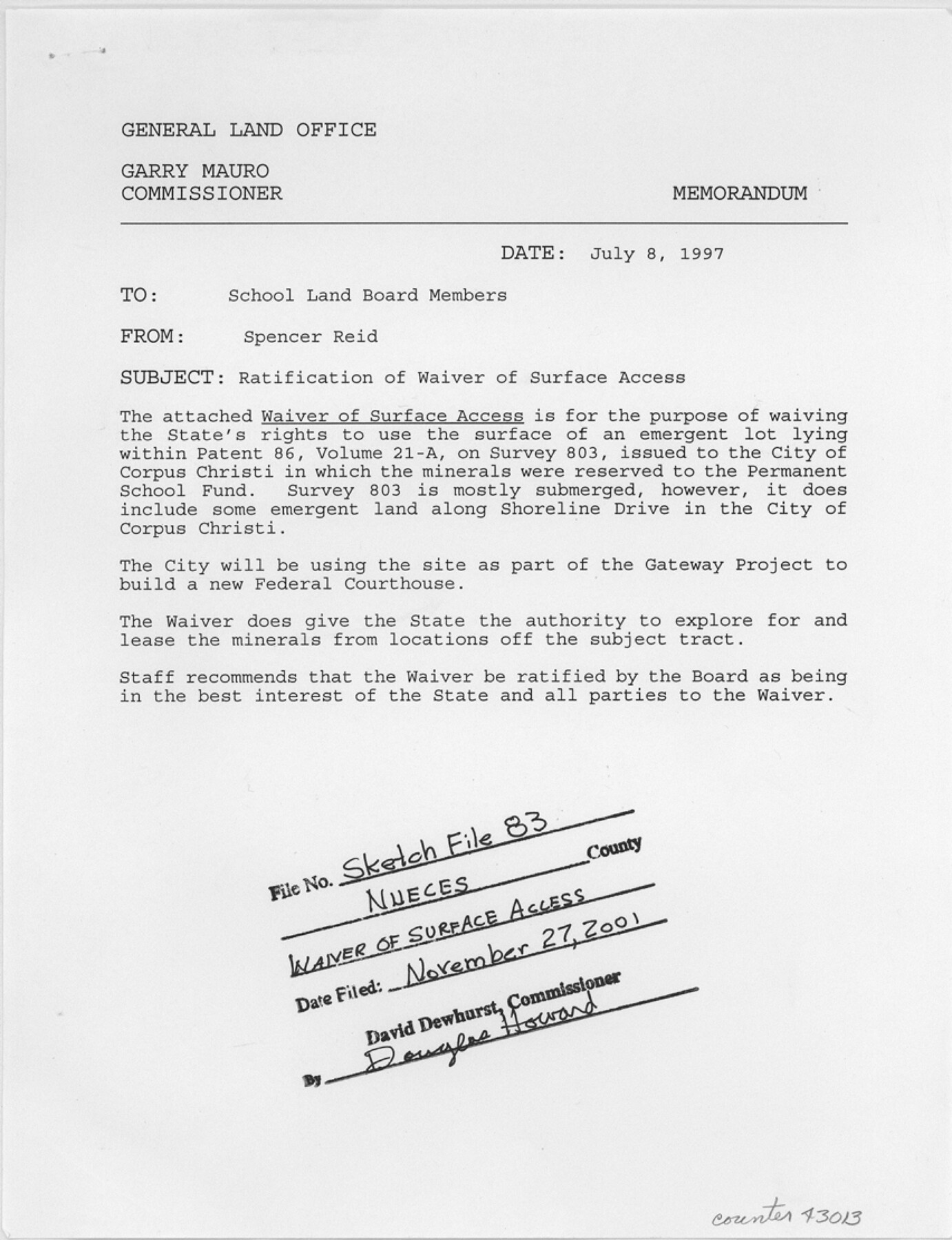
Nueces County Sketch File 83
[Ratification of waiver of surface access]
-
Map/Doc
43013
-
Collection
General Map Collection
-
Object Dates
7/7/1997 (Creation Date)
11/27/2001 (File Date)
7/8/1997 (Correspondence Date)
-
People and Organizations
Garry Mauro (GLO Commissioner)
-
Counties
Nueces
-
Subjects
Surveying Sketch File
-
Height x Width
11.1 x 8.5 inches
28.2 x 21.6 cm
-
Medium
multi-page, multi-format
-
Features
Bluff Park
Shoreline Boulevard
Mesquite Street
High Level Bridge
Southgate School
Souty Bluff Park
Memorial Hospital
Morgan Avenue
Spoken Hospital
Emerald Cove
St. Joseph's School
Lipan Street
Ledraro Street
McCaughan Park
Sacred Heart School
Corpus Christi
Bayview Cemetery
Gulfside Park
Kiwanis Park
North Beach
Corpus Christi Beach
Spoil Island
Main Turning Basin
Corpus Christi Channel
Power Street
Interstate Highway 37
Business State Highway 44-D
Shoreline Drive
Water Street
Belden Street
Part of: General Map Collection
Flight Mission No. BRA-3M, Frame 195, Jefferson County

Print $20.00
- Digital $50.00
Flight Mission No. BRA-3M, Frame 195, Jefferson County
1953
Size 18.6 x 22.3 inches
Map/Doc 85410
Zapata County Boundary File 1

Print $2.00
- Digital $50.00
Zapata County Boundary File 1
Size 11.4 x 9.0 inches
Map/Doc 60227
Polk County Sketch File 16

Print $4.00
- Digital $50.00
Polk County Sketch File 16
1861
Size 7.9 x 11.1 inches
Map/Doc 34161
Hudspeth County Rolled Sketch 43A

Print $3.00
- Digital $50.00
Hudspeth County Rolled Sketch 43A
1958
Size 10.7 x 8.8 inches
Map/Doc 6252
Flight Mission No. BRA-16M, Frame 105, Jefferson County

Print $20.00
- Digital $50.00
Flight Mission No. BRA-16M, Frame 105, Jefferson County
1953
Size 18.5 x 22.1 inches
Map/Doc 85717
Childress County Working Sketch 1

Print $20.00
- Digital $50.00
Childress County Working Sketch 1
1907
Size 18.1 x 15.5 inches
Map/Doc 68017
Brazoria County NRC Article 33.136 Sketch 11

Print $24.00
- Digital $50.00
Brazoria County NRC Article 33.136 Sketch 11
2012
Size 24.0 x 18.0 inches
Map/Doc 94777
Hill County Sketch File 17

Print $4.00
- Digital $50.00
Hill County Sketch File 17
1860
Size 12.5 x 8.3 inches
Map/Doc 26484
Parker County Sketch File 42

Print $114.00
- Digital $50.00
Parker County Sketch File 42
1877
Size 14.4 x 12.0 inches
Map/Doc 33589
Hockley County Rolled Sketch 6

Print $40.00
- Digital $50.00
Hockley County Rolled Sketch 6
Size 30.6 x 48.2 inches
Map/Doc 6216
Newton County Working Sketch 11

Print $20.00
- Digital $50.00
Newton County Working Sketch 11
1941
Size 22.7 x 23.5 inches
Map/Doc 71257
Galveston Entrance

Print $20.00
- Digital $50.00
Galveston Entrance
1856
Size 16.4 x 20.3 inches
Map/Doc 69857
You may also like
Pecos County Sketch File 43

Print $20.00
- Digital $50.00
Pecos County Sketch File 43
Size 16.1 x 30.4 inches
Map/Doc 12178
[Part of Eastern Texas RR. Co. Block 1]
![91898, [Part of Eastern Texas RR. Co. Block 1], Twichell Survey Records](https://historictexasmaps.com/wmedia_w700/maps/91898-1.tif.jpg)
Print $20.00
- Digital $50.00
[Part of Eastern Texas RR. Co. Block 1]
Size 21.2 x 12.2 inches
Map/Doc 91898
Terrell County Sketch File 26

Print $38.00
- Digital $50.00
Terrell County Sketch File 26
1937
Size 10.9 x 8.2 inches
Map/Doc 37961
Duval County Sketch File 79

Print $46.00
- Digital $50.00
Duval County Sketch File 79
1925
Size 14.3 x 9.1 inches
Map/Doc 21469
Hutchinson County Boundary File 4

Print $17.00
- Digital $50.00
Hutchinson County Boundary File 4
Size 14.3 x 8.7 inches
Map/Doc 55305
Brazoria County NRC Article 33.136 Sketch 12

Print $26.00
- Digital $50.00
Brazoria County NRC Article 33.136 Sketch 12
2010
Size 21.0 x 34.0 inches
Map/Doc 93407
Flight Mission No. BQY-1T, Frame 74, Harris County

Print $20.00
- Digital $50.00
Flight Mission No. BQY-1T, Frame 74, Harris County
1957
Size 17.5 x 17.6 inches
Map/Doc 85294
Plat Showing Survey for Harvest Queen Mills in Sec. 2 Blk. A & Sec. 4 Blk. O Lubbock County, Texas

Print $20.00
- Digital $50.00
Plat Showing Survey for Harvest Queen Mills in Sec. 2 Blk. A & Sec. 4 Blk. O Lubbock County, Texas
1956
Size 36.9 x 39.5 inches
Map/Doc 89893
Lovington Lea County, New Mexico

Print $20.00
- Digital $50.00
Lovington Lea County, New Mexico
Size 19.3 x 31.6 inches
Map/Doc 92419
Flight Mission No. BRA-6M, Frame 85, Jefferson County

Print $20.00
- Digital $50.00
Flight Mission No. BRA-6M, Frame 85, Jefferson County
1953
Size 18.6 x 22.4 inches
Map/Doc 85429
Nueces County Rolled Sketch 4

Print $20.00
- Digital $50.00
Nueces County Rolled Sketch 4
1910
Size 39.8 x 38.5 inches
Map/Doc 9583
Flight Mission No. CGI-3N, Frame 175, Cameron County

Print $20.00
- Digital $50.00
Flight Mission No. CGI-3N, Frame 175, Cameron County
1954
Size 18.6 x 22.3 inches
Map/Doc 84639