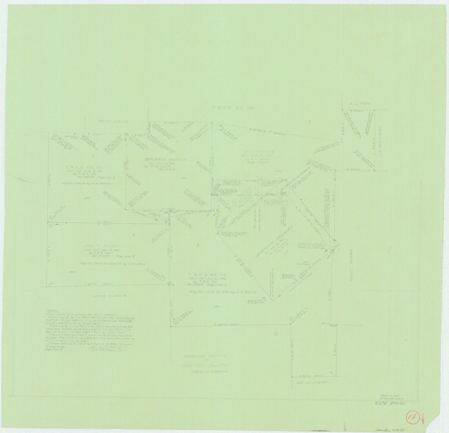
Newton County Working Sketch 11
-
Map/Doc
71257
-
Collection
General Map Collection
-
Object Dates
9/10/1941 (Creation Date)
-
People and Organizations
Dorothy H. Underwood (Draftsman)
-
Counties
Newton
-
Subjects
Surveying Working Sketch
-
Height x Width
22.7 x 23.5 inches
57.7 x 59.7 cm
-
Scale
1" = 300 varas
Part of: General Map Collection
Harrison County State Real Property Sketch 2

Print $20.00
- Digital $50.00
Harrison County State Real Property Sketch 2
1986
Size 23.9 x 25.0 inches
Map/Doc 61667
Jasper County Working Sketch 31

Print $20.00
- Digital $50.00
Jasper County Working Sketch 31
1963
Size 38.2 x 37.7 inches
Map/Doc 66493
Runnels County Sketch File 23

Print $20.00
Runnels County Sketch File 23
1924
Size 21.2 x 19.9 inches
Map/Doc 12257
Crockett County Sketch File 84

Print $6.00
- Digital $50.00
Crockett County Sketch File 84
1942
Size 11.4 x 8.9 inches
Map/Doc 19905
Jeff Davis County Sketch File 46

Print $8.00
- Digital $50.00
Jeff Davis County Sketch File 46
1906
Size 13.5 x 8.8 inches
Map/Doc 28080
Stonewall County Sketch File 29

Print $4.00
- Digital $50.00
Stonewall County Sketch File 29
1976
Size 11.3 x 8.5 inches
Map/Doc 37306
[Surveys in the Bexar and San Patricio Districts along the Nueces and Frio Rivers]
![36, [Surveys in the Bexar and San Patricio Districts along the Nueces and Frio Rivers], General Map Collection](https://historictexasmaps.com/wmedia_w700/maps/36.tif.jpg)
Print $20.00
- Digital $50.00
[Surveys in the Bexar and San Patricio Districts along the Nueces and Frio Rivers]
1830
Size 21.5 x 27.3 inches
Map/Doc 36
Garza County Sketch File G

Print $8.00
- Digital $50.00
Garza County Sketch File G
1904
Size 14.3 x 8.6 inches
Map/Doc 24026
Mason County Working Sketch 3

Print $20.00
- Digital $50.00
Mason County Working Sketch 3
1911
Size 17.8 x 22.9 inches
Map/Doc 70839
Kenedy County Boundary File 2

Print $22.00
- Digital $50.00
Kenedy County Boundary File 2
Size 11.2 x 8.6 inches
Map/Doc 55782
Boundary Between the United States & Mexico Agreed Upon by the Joint Commission under the Treaty of Guadalupe Hidalgo

Print $4.00
- Digital $50.00
Boundary Between the United States & Mexico Agreed Upon by the Joint Commission under the Treaty of Guadalupe Hidalgo
1853
Size 24.5 x 18.4 inches
Map/Doc 65394
Map of Eastland Co.

Print $20.00
- Digital $50.00
Map of Eastland Co.
1896
Size 40.8 x 43.8 inches
Map/Doc 66809
You may also like
Culberson County Rolled Sketch 68

Print $20.00
- Digital $50.00
Culberson County Rolled Sketch 68
1997
Size 32.0 x 32.9 inches
Map/Doc 76402
Sketch Showing Original Corners Affecting Block I and Adjacent Surveys from Actual Connections by W. D. Twichell

Print $20.00
- Digital $50.00
Sketch Showing Original Corners Affecting Block I and Adjacent Surveys from Actual Connections by W. D. Twichell
Size 23.4 x 24.4 inches
Map/Doc 90162
Navarro County Sketch File 1

Print $4.00
- Digital $50.00
Navarro County Sketch File 1
Size 9.9 x 8.0 inches
Map/Doc 32296
Current Miscellaneous File 49

Print $4.00
- Digital $50.00
Current Miscellaneous File 49
Size 11.2 x 8.8 inches
Map/Doc 74012
Index sheet to accompany map of survey for connecting the inland waters along margin of the Gulf of Mexico from Donaldsonville in Louisiana to the Rio Grande River in Texas

Print $20.00
- Digital $50.00
Index sheet to accompany map of survey for connecting the inland waters along margin of the Gulf of Mexico from Donaldsonville in Louisiana to the Rio Grande River in Texas
1874
Size 18.2 x 27.1 inches
Map/Doc 72696
Survey of Improvements on Meeks Gin Site Town of Ropes Hockley County, Texas

Print $20.00
- Digital $50.00
Survey of Improvements on Meeks Gin Site Town of Ropes Hockley County, Texas
1957
Size 13.0 x 17.6 inches
Map/Doc 92214
Polk County Working Sketch 23b

Print $40.00
- Digital $50.00
Polk County Working Sketch 23b
1957
Size 28.8 x 54.6 inches
Map/Doc 71639
Kinney County Rolled Sketch 20

Print $40.00
- Digital $50.00
Kinney County Rolled Sketch 20
1979
Size 37.8 x 59.7 inches
Map/Doc 9357
Flight Mission No. CLL-4N, Frame 32, Willacy County

Print $20.00
- Digital $50.00
Flight Mission No. CLL-4N, Frame 32, Willacy County
1954
Size 18.5 x 22.1 inches
Map/Doc 87105
Terrell County Sketch File 42

Print $20.00
- Digital $50.00
Terrell County Sketch File 42
1885
Map/Doc 97199

Andrews County Sketch File 15

Print $24.00
- Digital $50.00
Andrews County Sketch File 15
Size 11.2 x 8.9 inches
Map/Doc 12887