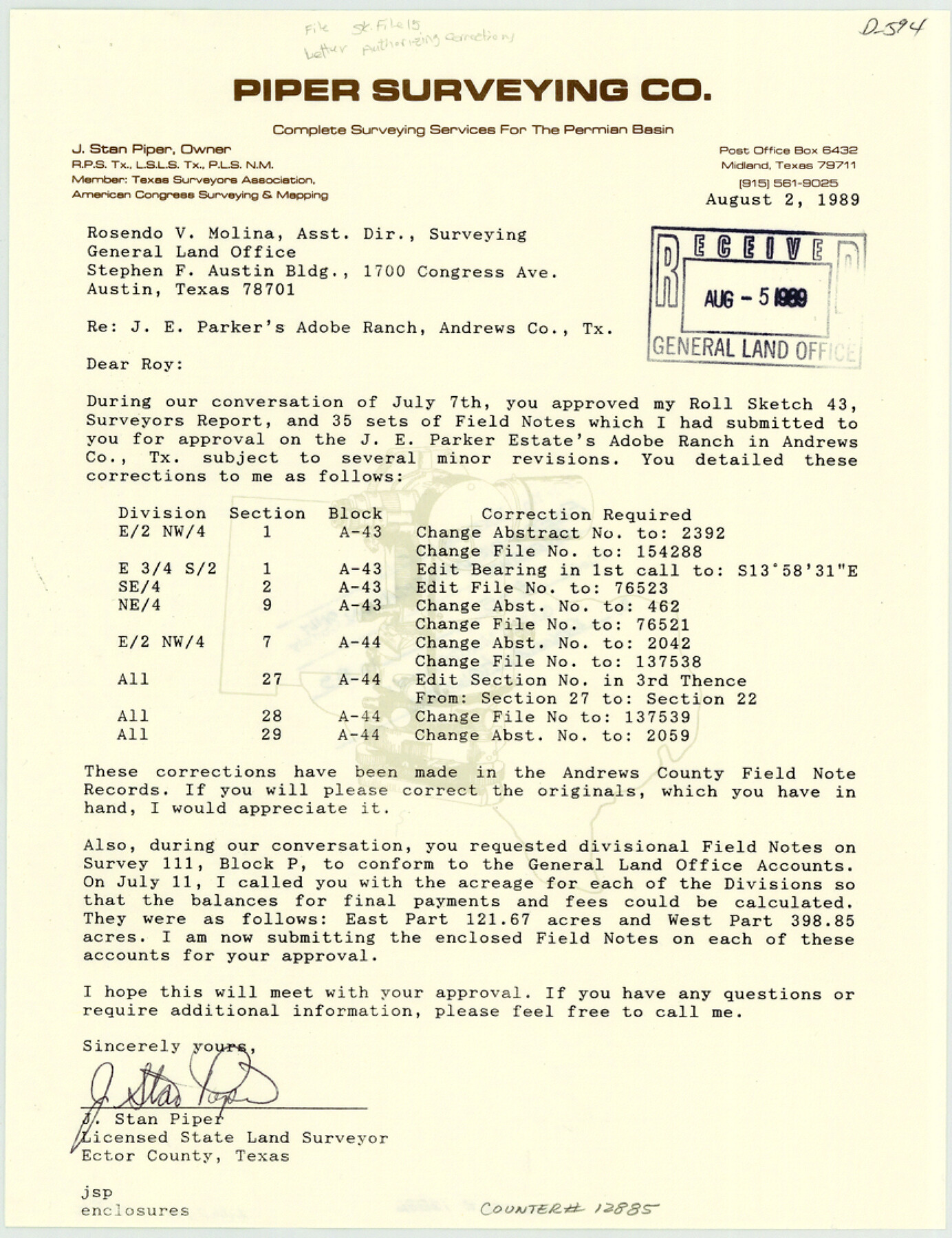
Andrews County Sketch File 15
[Surveyor's report and letter regarding the J.E. Parker's estate, Adobe Ranch]
-
Map/Doc
12887
-
Collection
General Map Collection
-
Object Dates
1989/5/23 (Correspondence Date)
1989/6/7 (File Date)
1989/8/5 (File Date)
1989/8/2 (Correspondence Date)
-
People and Organizations
J. Stan Piper (Surveyor/Engineer)
-
Counties
Andrews
-
Subjects
Surveying Sketch File
-
Height x Width
11.2 x 8.9 inches
28.4 x 22.6 cm
-
Medium
paper, print
-
Comments
See Andrews County Rolled Sketch 43 (77183) and Andrews County Rolled Sketch 44 (94990) for sketches.
-
Features
Adobe Ranch
Related maps
Andrews County Rolled Sketch 43

Print $20.00
- Digital $50.00
Andrews County Rolled Sketch 43
Size 26.1 x 41.0 inches
Map/Doc 77183
Andrews County Rolled Sketch 44

Print $40.00
- Digital $50.00
Andrews County Rolled Sketch 44
1990
Size 37.0 x 64.8 inches
Map/Doc 94990
Part of: General Map Collection
Flight Mission No. DCL-3C, Frame 106, Kenedy County

Print $20.00
- Digital $50.00
Flight Mission No. DCL-3C, Frame 106, Kenedy County
1943
Size 18.7 x 22.3 inches
Map/Doc 85801
[Sketch for Mineral Application 24072, San Jacinto River]
![65585, [Sketch for Mineral Application 24072, San Jacinto River], General Map Collection](https://historictexasmaps.com/wmedia_w700/maps/65585.tif.jpg)
Print $20.00
- Digital $50.00
[Sketch for Mineral Application 24072, San Jacinto River]
1929
Size 21.7 x 11.1 inches
Map/Doc 65585
Clay County Sketch File 33

Print $4.00
- Digital $50.00
Clay County Sketch File 33
Size 12.0 x 7.6 inches
Map/Doc 18459
Fannin County Boundary File 5

Print $44.00
- Digital $50.00
Fannin County Boundary File 5
Size 22.3 x 7.7 inches
Map/Doc 53309
Andrews County Boundary File 5

Print $40.00
- Digital $50.00
Andrews County Boundary File 5
Size 29.8 x 19.6 inches
Map/Doc 49723
Dimmit County Working Sketch 15

Print $20.00
- Digital $50.00
Dimmit County Working Sketch 15
1942
Size 19.0 x 34.5 inches
Map/Doc 68676
Right of Way and Track Map International & Gt Northern Ry. operated by the International & Gt. Northern Ry. Co., San Antonio Division

Print $40.00
- Digital $50.00
Right of Way and Track Map International & Gt Northern Ry. operated by the International & Gt. Northern Ry. Co., San Antonio Division
1917
Size 25.6 x 58.1 inches
Map/Doc 64587
The Coast of Texas

Print $20.00
- Digital $50.00
The Coast of Texas
1844
Size 18.2 x 27.0 inches
Map/Doc 72700
Jackson County Sketch File 17

Print $20.00
- Digital $50.00
Jackson County Sketch File 17
1913
Size 19.4 x 19.1 inches
Map/Doc 11841
Nacogdoches County Sketch File 1

Print $4.00
- Digital $50.00
Nacogdoches County Sketch File 1
Size 10.2 x 7.8 inches
Map/Doc 32233
Travis County Boundary File 2

Print $42.00
- Digital $50.00
Travis County Boundary File 2
Size 9.3 x 7.2 inches
Map/Doc 59406
Texas & Pacific R. R. through Pecos-Presidio Counties

Print $40.00
- Digital $50.00
Texas & Pacific R. R. through Pecos-Presidio Counties
Size 20.3 x 70.7 inches
Map/Doc 64282
You may also like
[Southwest corner Runnels County School Land League 3 and vicinity]
![93115, [Southwest corner Runnels County School Land League 3 and vicinity], Twichell Survey Records](https://historictexasmaps.com/wmedia_w700/maps/93115-1.tif.jpg)
Print $20.00
- Digital $50.00
[Southwest corner Runnels County School Land League 3 and vicinity]
Size 42.6 x 32.0 inches
Map/Doc 93115
Jefferson County Sketch File 18

Print $40.00
- Digital $50.00
Jefferson County Sketch File 18
Size 15.7 x 14.0 inches
Map/Doc 28167
Finder Map of Greater San Antonio

Print $20.00
- Digital $50.00
Finder Map of Greater San Antonio
1950
Size 28.7 x 21.4 inches
Map/Doc 94029
[Part of Block GG and river sections 69-79]
![90470, [Part of Block GG and river sections 69-79], Twichell Survey Records](https://historictexasmaps.com/wmedia_w700/maps/90470-1.tif.jpg)
Print $20.00
- Digital $50.00
[Part of Block GG and river sections 69-79]
Size 43.2 x 31.2 inches
Map/Doc 90470
[Letter from T. F. Pinckney to W. D. Twichell accompanying sketch showing Blocks 14, 341, and G5]
![93110, [Letter from T. F. Pinckney to W. D. Twichell accompanying sketch showing Blocks 14, 341, and G5], Twichell Survey Records](https://historictexasmaps.com/wmedia_w700/maps/93110-1.tif.jpg)
Print $2.00
- Digital $50.00
[Letter from T. F. Pinckney to W. D. Twichell accompanying sketch showing Blocks 14, 341, and G5]
1911
Size 8.0 x 9.5 inches
Map/Doc 93110
Flight Mission No. CRK-3P, Frame 177, Refugio County

Print $20.00
- Digital $50.00
Flight Mission No. CRK-3P, Frame 177, Refugio County
1956
Size 18.6 x 22.4 inches
Map/Doc 86924
Harrison County

Print $20.00
- Digital $50.00
Harrison County
1920
Size 43.8 x 40.8 inches
Map/Doc 95523
Brown County Working Sketch 20

Print $20.00
- Digital $50.00
Brown County Working Sketch 20
2011
Size 32.8 x 34.8 inches
Map/Doc 89999
Trace of a copy of the map captured at the battle of Resaca de la Palma

Print $20.00
- Digital $50.00
Trace of a copy of the map captured at the battle of Resaca de la Palma
Size 18.3 x 27.3 inches
Map/Doc 73056
Gulf of Mexico

Print $20.00
- Digital $50.00
Gulf of Mexico
1908
Size 18.4 x 27.0 inches
Map/Doc 72657
Grimes Estate Lands, Cochran County, Texas

Print $20.00
- Digital $50.00
Grimes Estate Lands, Cochran County, Texas
Size 25.6 x 21.6 inches
Map/Doc 92520
Isham Tubbs Estate

Print $3.00
- Digital $50.00
Isham Tubbs Estate
1947
Size 15.5 x 9.3 inches
Map/Doc 92304