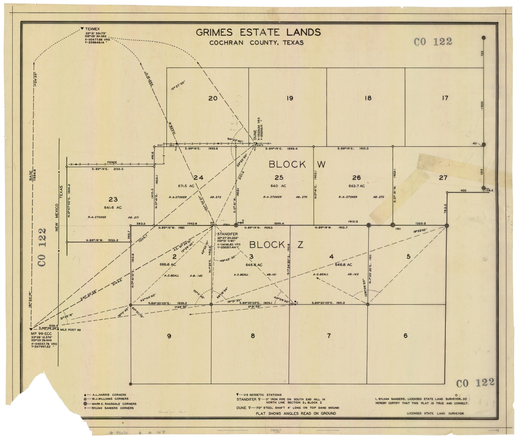
Grimes Estate Lands, Cochran County, Texas
CO122
-
Map/Doc
92520
-
Collection
Twichell Survey Records
-
People and Organizations
Sylvan Sanders (Surveyor/Engineer)
-
Counties
Cochran
-
Height x Width
25.6 x 21.6 inches
65.0 x 54.9 cm
Part of: Twichell Survey Records
![91461, [Block B7], Twichell Survey Records](https://historictexasmaps.com/wmedia_w700/maps/91461-1.tif.jpg)
[Castro, Lamb, Hockley, Swisher, Hale, and Lubbock Counties]
![91026, [Castro, Lamb, Hockley, Swisher, Hale, and Lubbock Counties], Twichell Survey Records](https://historictexasmaps.com/wmedia_w700/maps/91026-1.tif.jpg)
Print $20.00
- Digital $50.00
[Castro, Lamb, Hockley, Swisher, Hale, and Lubbock Counties]
Size 28.7 x 37.6 inches
Map/Doc 91026
Ownership Map SW 1/4 Lubbock County

Print $20.00
- Digital $50.00
Ownership Map SW 1/4 Lubbock County
Size 33.7 x 36.8 inches
Map/Doc 89697

Bryan Walker Farm

Print $20.00
- Digital $50.00
Bryan Walker Farm
Size 17.1 x 15.5 inches
Map/Doc 92339
[Block D, John H. Gibson]
![92003, [Block D, John H. Gibson], Twichell Survey Records](https://historictexasmaps.com/wmedia_w700/maps/92003-1.tif.jpg)
Print $20.00
- Digital $50.00
[Block D, John H. Gibson]
Size 33.2 x 18.4 inches
Map/Doc 92003
Map of Garza County, Texas

Print $20.00
- Digital $50.00
Map of Garza County, Texas
1936
Size 28.7 x 36.3 inches
Map/Doc 92648
[Connection to Block M-6 and west Castro and Swisher]
![93041, [Connection to Block M-6 and west Castro and Swisher], Twichell Survey Records](https://historictexasmaps.com/wmedia_w700/maps/93041-1.tif.jpg)
Print $40.00
- Digital $50.00
[Connection to Block M-6 and west Castro and Swisher]
Size 60.9 x 28.3 inches
Map/Doc 93041
Hutchinson County Map

Print $20.00
- Digital $50.00
Hutchinson County Map
Size 18.1 x 19.4 inches
Map/Doc 91185
Thomas Ross Survey

Print $20.00
- Digital $50.00
Thomas Ross Survey
1954
Size 16.8 x 17.6 inches
Map/Doc 92181
[In Northwest 1/4 of County in the vicinity of the John Walker Survey]
![90898, [In Northwest 1/4 of County in the vicinity of the John Walker Survey], Twichell Survey Records](https://historictexasmaps.com/wmedia_w700/maps/90898-1.tif.jpg)
Print $20.00
- Digital $50.00
[In Northwest 1/4 of County in the vicinity of the John Walker Survey]
Size 14.4 x 24.3 inches
Map/Doc 90898
"G" Sketch from Gaines County

Print $20.00
- Digital $50.00
"G" Sketch from Gaines County
1902
Size 31.6 x 21.8 inches
Map/Doc 90845
You may also like
Roberts County Rolled Sketch 3

Print $40.00
- Digital $50.00
Roberts County Rolled Sketch 3
Size 38.0 x 49.7 inches
Map/Doc 8356
Map of Giddings

Print $20.00
- Digital $50.00
Map of Giddings
1940
Size 16.5 x 21.2 inches
Map/Doc 2210
General Highway Map, Milam County, Texas

Print $20.00
General Highway Map, Milam County, Texas
1940
Size 18.5 x 24.8 inches
Map/Doc 79198
Travis County Sketch File 66

Print $12.00
- Digital $50.00
Travis County Sketch File 66
1950
Size 14.2 x 9.0 inches
Map/Doc 38440
Val Verde County Rolled Sketch 76

Print $20.00
- Digital $50.00
Val Verde County Rolled Sketch 76
1976
Size 38.6 x 26.6 inches
Map/Doc 8139
Gaines County Rolled Sketch 11

Print $20.00
- Digital $50.00
Gaines County Rolled Sketch 11
1939
Size 22.4 x 32.9 inches
Map/Doc 5931
Map of Public Land on Mustang Island

Print $20.00
- Digital $50.00
Map of Public Land on Mustang Island
Size 21.9 x 17.5 inches
Map/Doc 82315
Culberson County Working Sketch 54

Print $20.00
- Digital $50.00
Culberson County Working Sketch 54
1974
Size 26.4 x 32.6 inches
Map/Doc 68508
Sherman County Rolled Sketch 4

Print $20.00
- Digital $50.00
Sherman County Rolled Sketch 4
Size 23.1 x 31.7 inches
Map/Doc 7786
Controlled Mosaic by Jack Amman Photogrammetric Engineers, Inc - Sheet 12

Print $20.00
- Digital $50.00
Controlled Mosaic by Jack Amman Photogrammetric Engineers, Inc - Sheet 12
1954
Size 20.0 x 24.0 inches
Map/Doc 83456
Hays County Rolled Sketch 31

Print $20.00
- Digital $50.00
Hays County Rolled Sketch 31
2001
Size 24.0 x 34.7 inches
Map/Doc 76421
Flight Mission No. BRE-2P, Frame 66, Nueces County

Print $20.00
- Digital $50.00
Flight Mission No. BRE-2P, Frame 66, Nueces County
1956
Size 18.6 x 22.5 inches
Map/Doc 86761