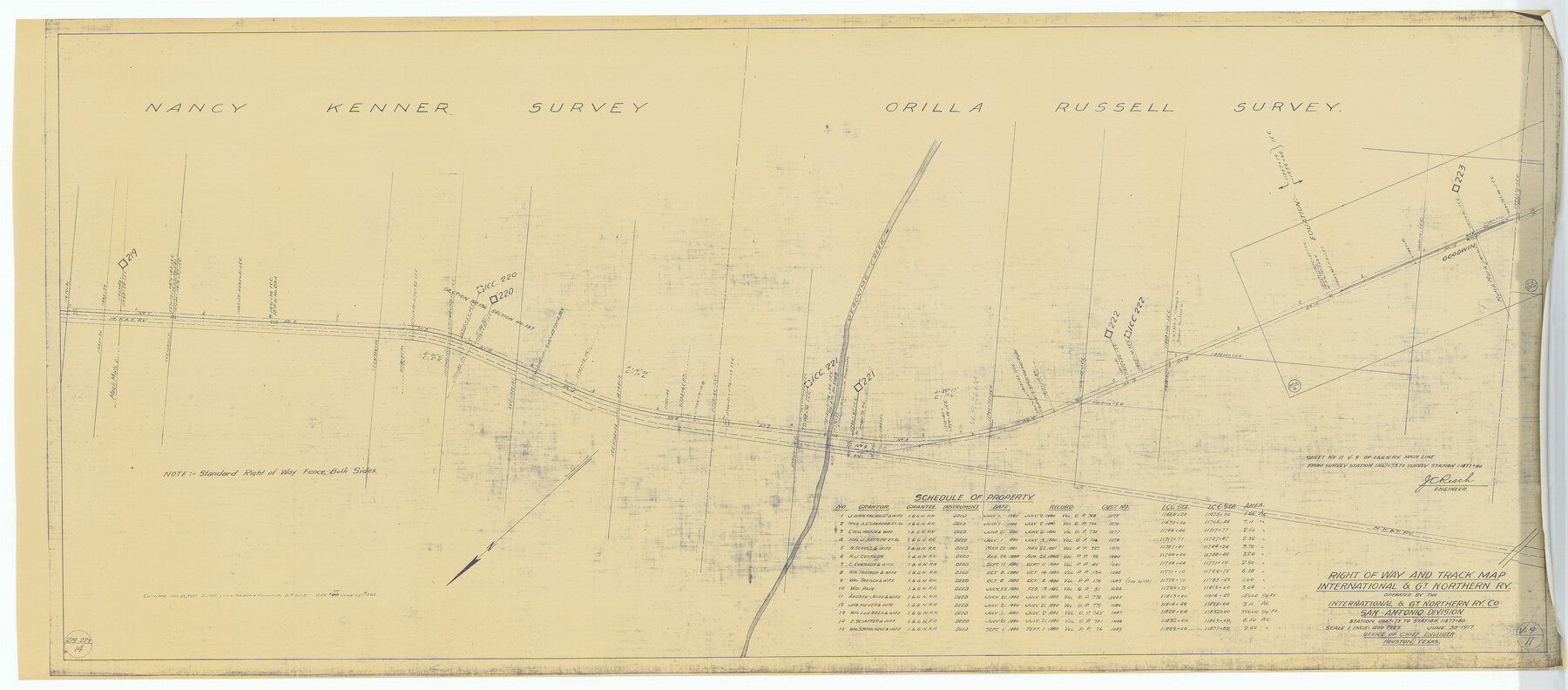
Right of Way and Track Map International & Gt Northern Ry. operated by the International & Gt. Northern Ry. Co., San Antonio Division
Station 11667+73 to Station 11877+80
Z-2-181
-
Map/Doc
64587
-
Collection
General Map Collection
-
Object Dates
1921/1/20 (Revision Date)
1917/6/19 (Creation Date)
-
People and Organizations
J. C. Resch (Surveyor/Engineer)
-
Counties
Comal
-
Subjects
Railroads
-
Height x Width
25.6 x 58.1 inches
65.0 x 147.6 cm
-
Medium
blueprint/diazo
-
Scale
1" = 400 feet
-
Comments
See counter nos. 64586 and 64588 through 64589 and 64787 through 64789 for other sheets of the map.
-
Features
I&GN
MK&T
Goodwin
Geronimo Creek
Part of: General Map Collection
Polk County Sketch File 20

Print $4.00
- Digital $50.00
Polk County Sketch File 20
Size 6.1 x 8.2 inches
Map/Doc 34167
Presidio County Sketch File 5

Print $4.00
- Digital $50.00
Presidio County Sketch File 5
1872
Size 12.9 x 8.2 inches
Map/Doc 34433
Presidio County Working Sketch 71

Print $20.00
- Digital $50.00
Presidio County Working Sketch 71
1961
Size 17.4 x 14.7 inches
Map/Doc 71748
Shackelford County Sketch File 1

Print $4.00
- Digital $50.00
Shackelford County Sketch File 1
1877
Size 12.8 x 8.0 inches
Map/Doc 36570
South Part Crockett County

Print $40.00
- Digital $50.00
South Part Crockett County
1977
Size 39.7 x 51.4 inches
Map/Doc 73122
Nueces County Sketch File 8

Print $22.00
- Digital $50.00
Nueces County Sketch File 8
1849
Size 8.2 x 12.4 inches
Map/Doc 32512
Photostat of section of hydrographic surveys H-5399, H-4822, H-470

Print $20.00
- Digital $50.00
Photostat of section of hydrographic surveys H-5399, H-4822, H-470
1933
Size 18.3 x 25.8 inches
Map/Doc 61156
Kent County Boundary File 1

Print $54.00
- Digital $50.00
Kent County Boundary File 1
Size 14.2 x 8.5 inches
Map/Doc 55795
Crockett County Sketch File 84

Print $6.00
- Digital $50.00
Crockett County Sketch File 84
1942
Size 11.4 x 8.9 inches
Map/Doc 19905
Montgomery County Working Sketch 23

Print $20.00
- Digital $50.00
Montgomery County Working Sketch 23
1937
Size 42.5 x 37.2 inches
Map/Doc 71130
Tarrant County Sketch File 31

Print $20.00
- Digital $50.00
Tarrant County Sketch File 31
Size 27.2 x 39.3 inches
Map/Doc 10380
Presidio County Working Sketch 84

Print $20.00
- Digital $50.00
Presidio County Working Sketch 84
1970
Size 20.7 x 17.8 inches
Map/Doc 71761
You may also like
The Republic County of Bastrop. December 29, 1845

Print $20.00
The Republic County of Bastrop. December 29, 1845
2020
Size 14.8 x 21.7 inches
Map/Doc 96092
Edwards County Working Sketch 65

Print $20.00
- Digital $50.00
Edwards County Working Sketch 65
1956
Size 34.0 x 25.0 inches
Map/Doc 68941
Val Verde County Sketch File B2

Print $20.00
- Digital $50.00
Val Verde County Sketch File B2
1910
Size 24.5 x 12.2 inches
Map/Doc 12544
Rusk County Rolled Sketch OBS

Print $20.00
- Digital $50.00
Rusk County Rolled Sketch OBS
1937
Size 26.3 x 21.8 inches
Map/Doc 7550
Presidio County Sketch File 91

Print $40.00
- Digital $50.00
Presidio County Sketch File 91
Size 12.3 x 15.9 inches
Map/Doc 34763
Gonzales County Working Sketch 13

Print $2.00
- Digital $50.00
Gonzales County Working Sketch 13
1981
Size 12.5 x 7.6 inches
Map/Doc 63229
![92161, [Block K], Twichell Survey Records](https://historictexasmaps.com/wmedia_w700/maps/92161-1.tif.jpg)
Jefferson County Working Sketch 25

Print $20.00
- Digital $50.00
Jefferson County Working Sketch 25
1977
Size 39.8 x 43.4 inches
Map/Doc 66568
General Highway Map, Armstrong County, Texas

Print $20.00
General Highway Map, Armstrong County, Texas
1961
Size 18.3 x 25.0 inches
Map/Doc 79354
Concho County Sketch File 46

Print $24.00
- Digital $50.00
Concho County Sketch File 46
1961
Size 14.2 x 8.6 inches
Map/Doc 19213

[Township 3 North, Block 34]
![91208, [Township 3 North, Block 34], Twichell Survey Records](https://historictexasmaps.com/wmedia_w700/maps/91208-1.tif.jpg)
Print $3.00
- Digital $50.00
[Township 3 North, Block 34]
Size 10.2 x 14.0 inches
Map/Doc 91208