Presidio County Sketch File 5
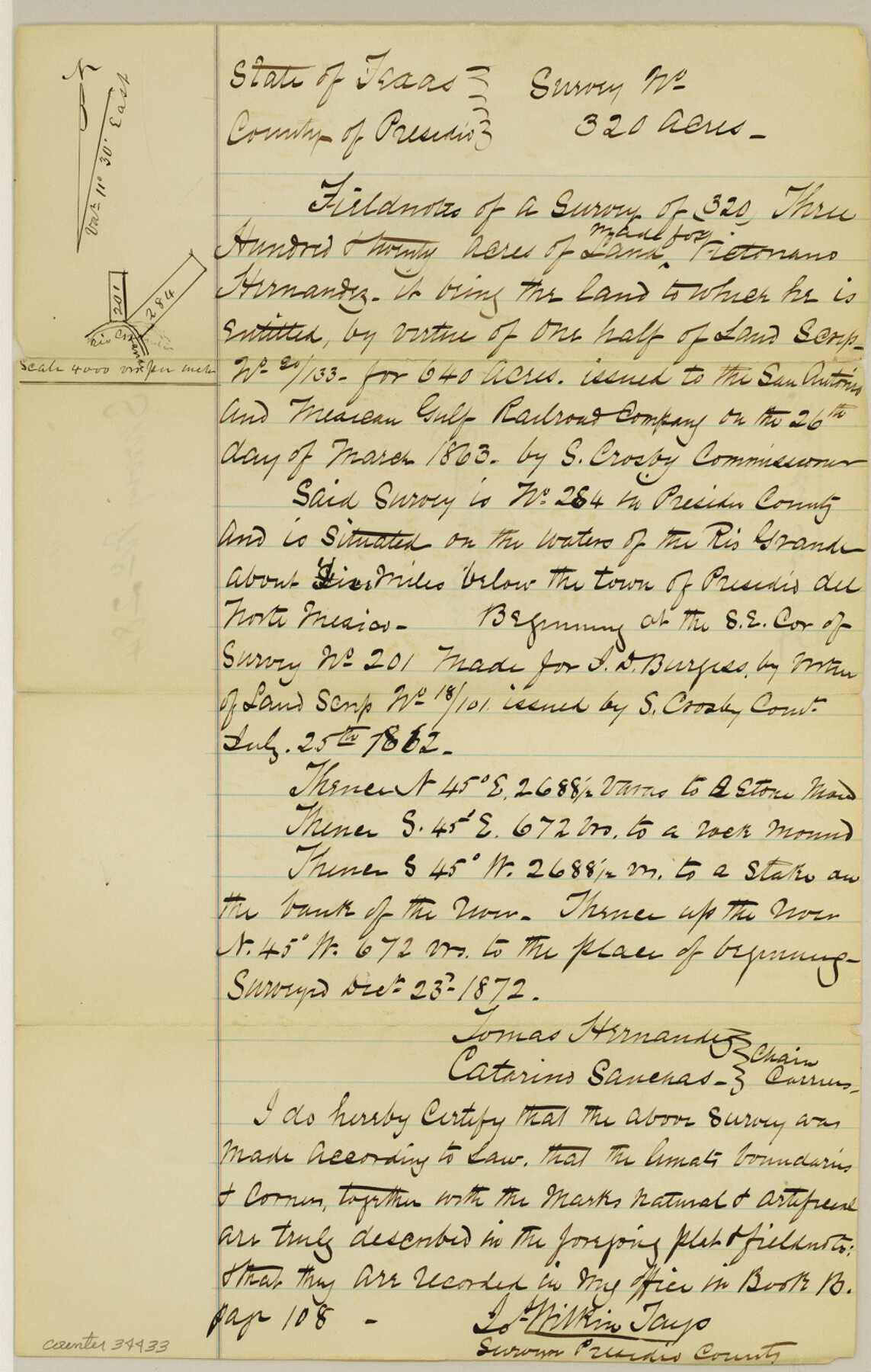
[Field notes and sketch of survey 284]
-
Map/Doc
34433
-
Collection
General Map Collection
-
Object Dates
12/23/1872 (Creation Date)
4/20/1874 (File Date)
-
People and Organizations
J.Wilkins Tays (Surveyor/Engineer)
Tomas Hernandez (Chainman/Field Personnel)
Catarino Sanchas (Chainman/Field Personnel)
-
Counties
Presidio
-
Subjects
Surveying Sketch File
-
Height x Width
12.9 x 8.2 inches
32.8 x 20.8 cm
-
Medium
paper, manuscript
-
Scale
1" = 4000 varas
-
Features
Rio Grande
Presidio Del Norte
Part of: General Map Collection
Buenaventura Reyes Grants

Print $20.00
- Digital $50.00
Buenaventura Reyes Grants
1896
Size 14.9 x 13.5 inches
Map/Doc 2057
Flight Mission No. DQN-2K, Frame 5, Calhoun County

Print $20.00
- Digital $50.00
Flight Mission No. DQN-2K, Frame 5, Calhoun County
1953
Size 18.5 x 22.2 inches
Map/Doc 84222
Baylor County Boundary File 15

Print $4.00
- Digital $50.00
Baylor County Boundary File 15
Size 10.1 x 8.0 inches
Map/Doc 50431
Presidio County Sketch File 116A

Print $63.00
- Digital $50.00
Presidio County Sketch File 116A
Size 17.0 x 11.0 inches
Map/Doc 34885
Dawson County Sketch File 29

Print $4.00
- Digital $50.00
Dawson County Sketch File 29
1892
Size 11.3 x 9.0 inches
Map/Doc 20592
Jack County Rolled Sketch 1

Print $20.00
- Digital $50.00
Jack County Rolled Sketch 1
1963
Size 24.4 x 22.5 inches
Map/Doc 6331
Wilbarger County Sketch File 7a

Print $4.00
- Digital $50.00
Wilbarger County Sketch File 7a
1885
Size 14.3 x 8.6 inches
Map/Doc 40177
Coke County Working Sketch 24

Print $20.00
- Digital $50.00
Coke County Working Sketch 24
1956
Size 28.7 x 31.1 inches
Map/Doc 68061
Flight Mission No. DIX-3P, Frame 168, Aransas County

Print $20.00
- Digital $50.00
Flight Mission No. DIX-3P, Frame 168, Aransas County
1956
Size 17.7 x 18.3 inches
Map/Doc 83774
Flight Mission No. DAG-14K, Frame 133, Matagorda County

Print $20.00
- Digital $50.00
Flight Mission No. DAG-14K, Frame 133, Matagorda County
1952
Size 17.6 x 17.4 inches
Map/Doc 86304
Menard County Working Sketch 34

Print $20.00
- Digital $50.00
Menard County Working Sketch 34
2003
Size 27.1 x 44.4 inches
Map/Doc 82028
Van Zandt County Sketch File 4

Print $6.00
- Digital $50.00
Van Zandt County Sketch File 4
1858
Size 10.7 x 11.1 inches
Map/Doc 39369
You may also like
Gillespie County Working Sketch 4

Print $20.00
- Digital $50.00
Gillespie County Working Sketch 4
1969
Size 32.5 x 35.3 inches
Map/Doc 63167
Map of the Mexican Central Railway and Connections

Print $20.00
- Digital $50.00
Map of the Mexican Central Railway and Connections
1892
Size 22.0 x 26.0 inches
Map/Doc 95742
H. W. Stanton's Subdivision of Northeast Quarter, Section 15, Block B

Print $20.00
- Digital $50.00
H. W. Stanton's Subdivision of Northeast Quarter, Section 15, Block B
Size 25.3 x 15.8 inches
Map/Doc 92788
Flight Mission No. BRA-16M, Frame 52, Jefferson County

Print $20.00
- Digital $50.00
Flight Mission No. BRA-16M, Frame 52, Jefferson County
1953
Size 18.5 x 22.6 inches
Map/Doc 85669
Johnson County Sketch File 10a

Print $4.00
- Digital $50.00
Johnson County Sketch File 10a
1877
Size 6.7 x 10.6 inches
Map/Doc 28445
Henderson County

Print $40.00
- Digital $50.00
Henderson County
1988
Size 35.3 x 69.7 inches
Map/Doc 95528
The Texas New Yorker's Map of the U. S. Accompanying the Map of Texas

Print $20.00
The Texas New Yorker's Map of the U. S. Accompanying the Map of Texas
1874
Size 32.3 x 22.8 inches
Map/Doc 76211
Cherokee County Sketch File 8

Print $4.00
- Digital $50.00
Cherokee County Sketch File 8
1854
Size 10.3 x 8.1 inches
Map/Doc 18130
From Citizens of Washington County Living East of the Brazos River and West of the Navasota River for the Creation of a New County (Unnamed), Undated

Print $20.00
From Citizens of Washington County Living East of the Brazos River and West of the Navasota River for the Creation of a New County (Unnamed), Undated
2020
Size 20.4 x 21.7 inches
Map/Doc 96408
University Land Loving-Ward-Winkler Counties

Print $20.00
- Digital $50.00
University Land Loving-Ward-Winkler Counties
1931
Size 24.7 x 33.2 inches
Map/Doc 2448
Atascosa County Working Sketch 25

Print $20.00
- Digital $50.00
Atascosa County Working Sketch 25
1958
Size 38.2 x 44.0 inches
Map/Doc 67221
Waco, Tex., County Seat of McLennan Co.

Print $20.00
Waco, Tex., County Seat of McLennan Co.
1886
Size 23.1 x 32.7 inches
Map/Doc 89212