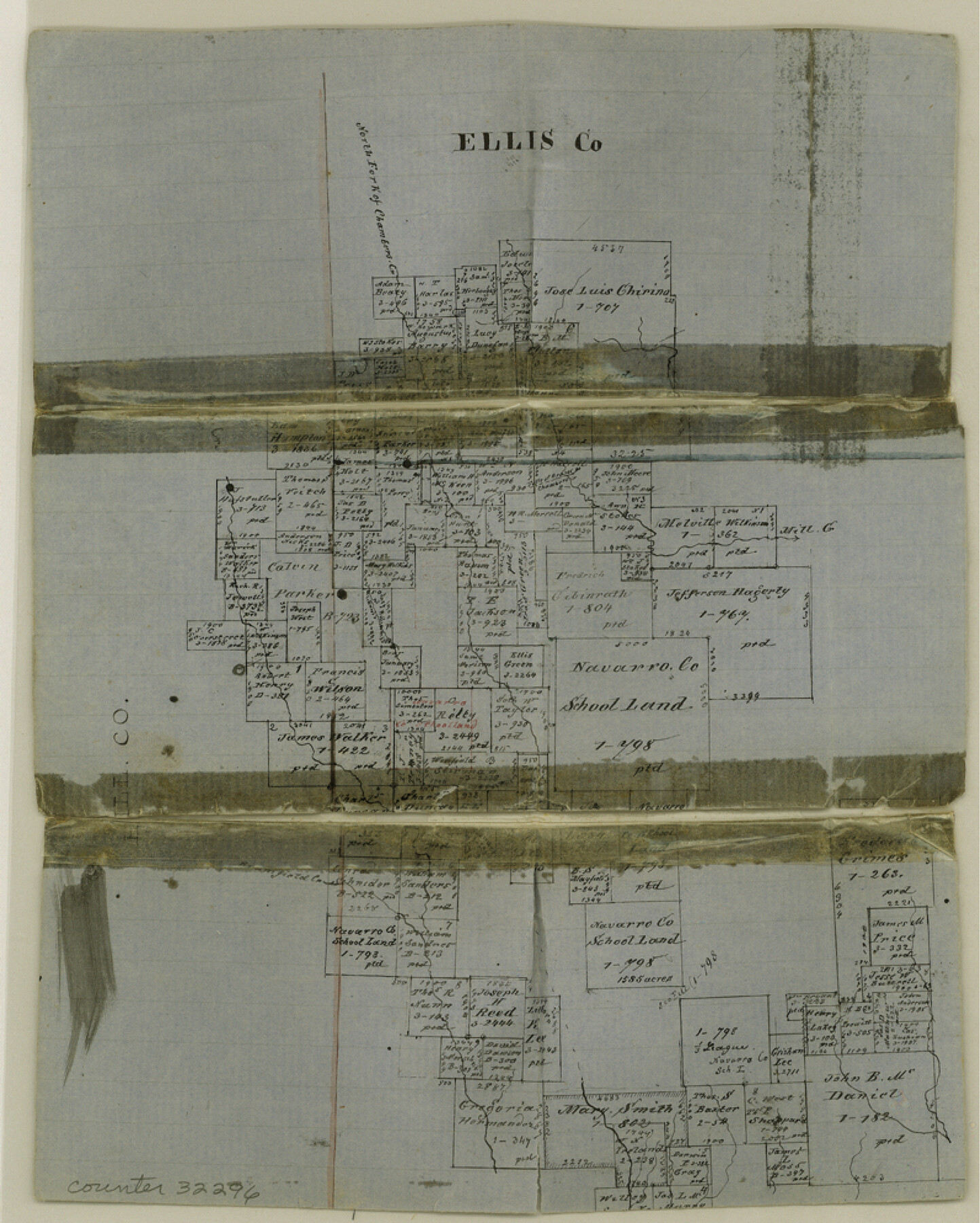
Navarro County Sketch File 1
[Sketch of area in northwest part of Navarro County and neighboring counties]
-
Map/Doc
32296
-
Collection
General Map Collection
-
Object Dates
2/12/1856 (File Date)
-
Counties
Navarro Hill Ellis
-
Subjects
Surveying Sketch File
-
Height x Width
9.9 x 8.0 inches
25.2 x 20.3 cm
-
Medium
paper, manuscript
-
Features
North Fork of Chambers Creek
Part of: General Map Collection
Lipscomb County Boundary File 3

Print $4.00
- Digital $50.00
Lipscomb County Boundary File 3
Size 8.2 x 6.5 inches
Map/Doc 56318
Wood County Boundary File 5

Print $20.00
- Digital $50.00
Wood County Boundary File 5
Size 10.8 x 8.1 inches
Map/Doc 60170
Map of Cooke County originally Fannin Land District

Print $20.00
- Digital $50.00
Map of Cooke County originally Fannin Land District
1858
Size 25.4 x 18.9 inches
Map/Doc 950
Hamilton County Working Sketch 21

Print $40.00
- Digital $50.00
Hamilton County Working Sketch 21
1955
Size 52.4 x 43.7 inches
Map/Doc 63359
Sutton County Working Sketch 24

Print $20.00
- Digital $50.00
Sutton County Working Sketch 24
1985
Size 32.6 x 42.5 inches
Map/Doc 62367
Glasscock County Sketch File 5

Print $20.00
- Digital $50.00
Glasscock County Sketch File 5
1929
Size 23.0 x 22.7 inches
Map/Doc 11561
Spanish Dominions in North America, Northern Part

Print $20.00
- Digital $50.00
Spanish Dominions in North America, Northern Part
1811
Size 22.1 x 30.5 inches
Map/Doc 95133
Gillespie County Boundary File 5a

Print $2.00
- Digital $50.00
Gillespie County Boundary File 5a
Size 8.3 x 7.9 inches
Map/Doc 53769
[Surveys in Austin's Colony near La Bahia Road]
![200, [Surveys in Austin's Colony near La Bahia Road], General Map Collection](https://historictexasmaps.com/wmedia_w700/maps/200.tif.jpg)
Print $20.00
- Digital $50.00
[Surveys in Austin's Colony near La Bahia Road]
1821
Size 10.4 x 20.2 inches
Map/Doc 200
Texas Aerial Photo-Illustrated Map

Texas Aerial Photo-Illustrated Map
Size 21.3 x 28.3 inches
Map/Doc 94398
Young County Rolled Sketch 7

Print $20.00
- Digital $50.00
Young County Rolled Sketch 7
Size 37.3 x 26.4 inches
Map/Doc 8295
Sectional Map No. 3 of the lands and of the line of the Texas & Pacific Ry. Co. in Reeves and parts of Tom Green, Pecos, Presidio & El Paso Cos.

Print $20.00
- Digital $50.00
Sectional Map No. 3 of the lands and of the line of the Texas & Pacific Ry. Co. in Reeves and parts of Tom Green, Pecos, Presidio & El Paso Cos.
1885
Size 22.3 x 17.4 inches
Map/Doc 2303
You may also like
[Sections 47-76 and part of Block 3]
![91807, [Sections 47-76 and part of Block 3], Twichell Survey Records](https://historictexasmaps.com/wmedia_w700/maps/91807-1.tif.jpg)
Print $20.00
- Digital $50.00
[Sections 47-76 and part of Block 3]
Size 34.1 x 31.7 inches
Map/Doc 91807
Hardin County Working Sketch 20

Print $20.00
- Digital $50.00
Hardin County Working Sketch 20
1947
Size 38.1 x 32.6 inches
Map/Doc 63418
Flight Mission No. DQN-5K, Frame 81, Calhoun County

Print $20.00
- Digital $50.00
Flight Mission No. DQN-5K, Frame 81, Calhoun County
1953
Size 18.5 x 22.2 inches
Map/Doc 84414
Fort Bend County Rolled Sketch 1

Print $20.00
- Digital $50.00
Fort Bend County Rolled Sketch 1
Size 24.3 x 27.5 inches
Map/Doc 5891
[Surveys along the Nueces River in San Patricio County]
![69737, [Surveys along the Nueces River in San Patricio County], General Map Collection](https://historictexasmaps.com/wmedia_w700/maps/69737.tif.jpg)
Print $2.00
- Digital $50.00
[Surveys along the Nueces River in San Patricio County]
1842
Size 8.8 x 9.9 inches
Map/Doc 69737
Swisher County Sketch File 2b

Print $4.00
- Digital $50.00
Swisher County Sketch File 2b
1910
Size 11.2 x 8.7 inches
Map/Doc 37616
Map of Kimble County, Texas

Print $20.00
- Digital $50.00
Map of Kimble County, Texas
1879
Size 18.1 x 28.3 inches
Map/Doc 527
Tarrant County Working Sketch 1

Print $20.00
- Digital $50.00
Tarrant County Working Sketch 1
1939
Size 12.2 x 18.9 inches
Map/Doc 62418
Flight Mission No. DQN-5K, Frame 145, Calhoun County

Print $20.00
- Digital $50.00
Flight Mission No. DQN-5K, Frame 145, Calhoun County
1953
Size 18.5 x 22.1 inches
Map/Doc 84420

Harris County NRC Article 33.136 Sketch 15

Print $28.00
- Digital $50.00
Harris County NRC Article 33.136 Sketch 15
2012
Size 24.0 x 18.0 inches
Map/Doc 94762
Map of the city of San Antonio, Bexar County, Texas including suburbs both north and south

Print $20.00
Map of the city of San Antonio, Bexar County, Texas including suburbs both north and south
1924
Size 37.0 x 24.5 inches
Map/Doc 93556