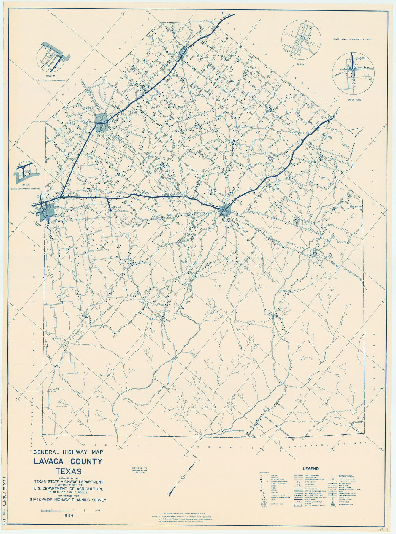
General Highway Map, Lavaca County, Texas
-
Map/Doc
79170
-
Collection
Texas State Library and Archives
-
Object Dates
1940 (Creation Date)
-
People and Organizations
Texas State Highway Department (Publisher)
-
Counties
Lavaca
-
Subjects
County
-
Height x Width
24.7 x 18.3 inches
62.7 x 46.5 cm
-
Comments
Prints available courtesy of the Texas State Library and Archives.
More info can be found here: TSLAC Map 04927
Part of: Texas State Library and Archives
General Highway Map, El Paso County, Texas

Print $20.00
General Highway Map, El Paso County, Texas
1961
Size 18.1 x 24.7 inches
Map/Doc 79457

General Highway Map. Detail of Cities and Towns in Lubbock County, Texas [Lubbock and vicinity]
![79579, General Highway Map. Detail of Cities and Towns in Lubbock County, Texas [Lubbock and vicinity], Texas State Library and Archives](https://historictexasmaps.com/wmedia_w700/maps/79579.tif.jpg)
Print $20.00
General Highway Map. Detail of Cities and Towns in Lubbock County, Texas [Lubbock and vicinity]
1961
Size 18.2 x 24.7 inches
Map/Doc 79579
General Highway Map, Parker County, Texas

Print $20.00
General Highway Map, Parker County, Texas
1961
Size 18.3 x 24.5 inches
Map/Doc 79625
General Highway Map, Martin County, Texas

Print $20.00
General Highway Map, Martin County, Texas
1961
Size 18.1 x 24.6 inches
Map/Doc 79583
General Highway Map. Detail of Cities and Towns in Bexar County, Texas. City Map of San Antonio, Alamo Heights, Olmos Park, Terrell Hills, Castle Hills, Balcones Heights, and vicinity, Bexar County, Texas

Print $20.00
General Highway Map. Detail of Cities and Towns in Bexar County, Texas. City Map of San Antonio, Alamo Heights, Olmos Park, Terrell Hills, Castle Hills, Balcones Heights, and vicinity, Bexar County, Texas
1961
Size 25.0 x 18.1 inches
Map/Doc 79374
General Highway Map, Limestone County, Texas

Print $20.00
General Highway Map, Limestone County, Texas
1940
Size 18.3 x 24.9 inches
Map/Doc 79174
General Highway Map, Polk County, Texas

Print $20.00
General Highway Map, Polk County, Texas
1940
Size 24.6 x 18.5 inches
Map/Doc 79219
General Highway Map, Camp County, Morris County, Titus County, Texas

Print $20.00
General Highway Map, Camp County, Morris County, Titus County, Texas
1961
Size 24.7 x 18.1 inches
Map/Doc 79400
J. De Cordova's Map of the State of Texas Compiled from the records of the General Land Office of the State

Print $20.00
J. De Cordova's Map of the State of Texas Compiled from the records of the General Land Office of the State
1872
Size 34.3 x 31.9 inches
Map/Doc 76216
General Highway Map, El Paso County, Texas

Print $20.00
General Highway Map, El Paso County, Texas
1961
Size 18.2 x 24.8 inches
Map/Doc 79458
General Highway Map, Knox County, Texas

Print $20.00
General Highway Map, Knox County, Texas
1940
Size 18.3 x 24.8 inches
Map/Doc 79166
You may also like
Flight Mission No. DQO-7K, Frame 112, Galveston County

Print $20.00
- Digital $50.00
Flight Mission No. DQO-7K, Frame 112, Galveston County
1952
Size 18.9 x 22.4 inches
Map/Doc 85127
Flight Mission No. BRA-16M, Frame 67, Jefferson County

Print $20.00
- Digital $50.00
Flight Mission No. BRA-16M, Frame 67, Jefferson County
1953
Size 18.6 x 22.4 inches
Map/Doc 85684
Hardin County Rolled Sketch 12

Print $20.00
- Digital $50.00
Hardin County Rolled Sketch 12
1949
Size 36.3 x 47.3 inches
Map/Doc 10200
Flight Mission No. DQN-1K, Frame 50, Calhoun County

Print $20.00
- Digital $50.00
Flight Mission No. DQN-1K, Frame 50, Calhoun County
1953
Size 18.7 x 22.3 inches
Map/Doc 84150
Preliminary Survey of the Entrance to the Rio Grande, Texas

Print $20.00
Preliminary Survey of the Entrance to the Rio Grande, Texas
1854
Size 14.2 x 14.9 inches
Map/Doc 95283
Presidio County Rolled Sketch 24

Print $40.00
- Digital $50.00
Presidio County Rolled Sketch 24
1886
Size 158.3 x 23.4 inches
Map/Doc 9765
Nueces County Sketch File 17

Print $20.00
- Digital $50.00
Nueces County Sketch File 17
1854
Size 24.8 x 26.6 inches
Map/Doc 42180
Map of Galveston County

Print $20.00
- Digital $50.00
Map of Galveston County
1883
Size 18.8 x 26.8 inches
Map/Doc 3573
Blanco County Sketch File 46

Print $4.00
- Digital $50.00
Blanco County Sketch File 46
Size 12.5 x 8.4 inches
Map/Doc 14673
Hunt County Sketch File 34

Print $6.00
- Digital $50.00
Hunt County Sketch File 34
Size 9.9 x 7.2 inches
Map/Doc 27143
Coryell County Working Sketch 25

Print $20.00
- Digital $50.00
Coryell County Working Sketch 25
1986
Size 22.2 x 29.4 inches
Map/Doc 68232
Duval County Rolled Sketch 36

Print $20.00
- Digital $50.00
Duval County Rolled Sketch 36
1952
Size 27.7 x 21.9 inches
Map/Doc 5751