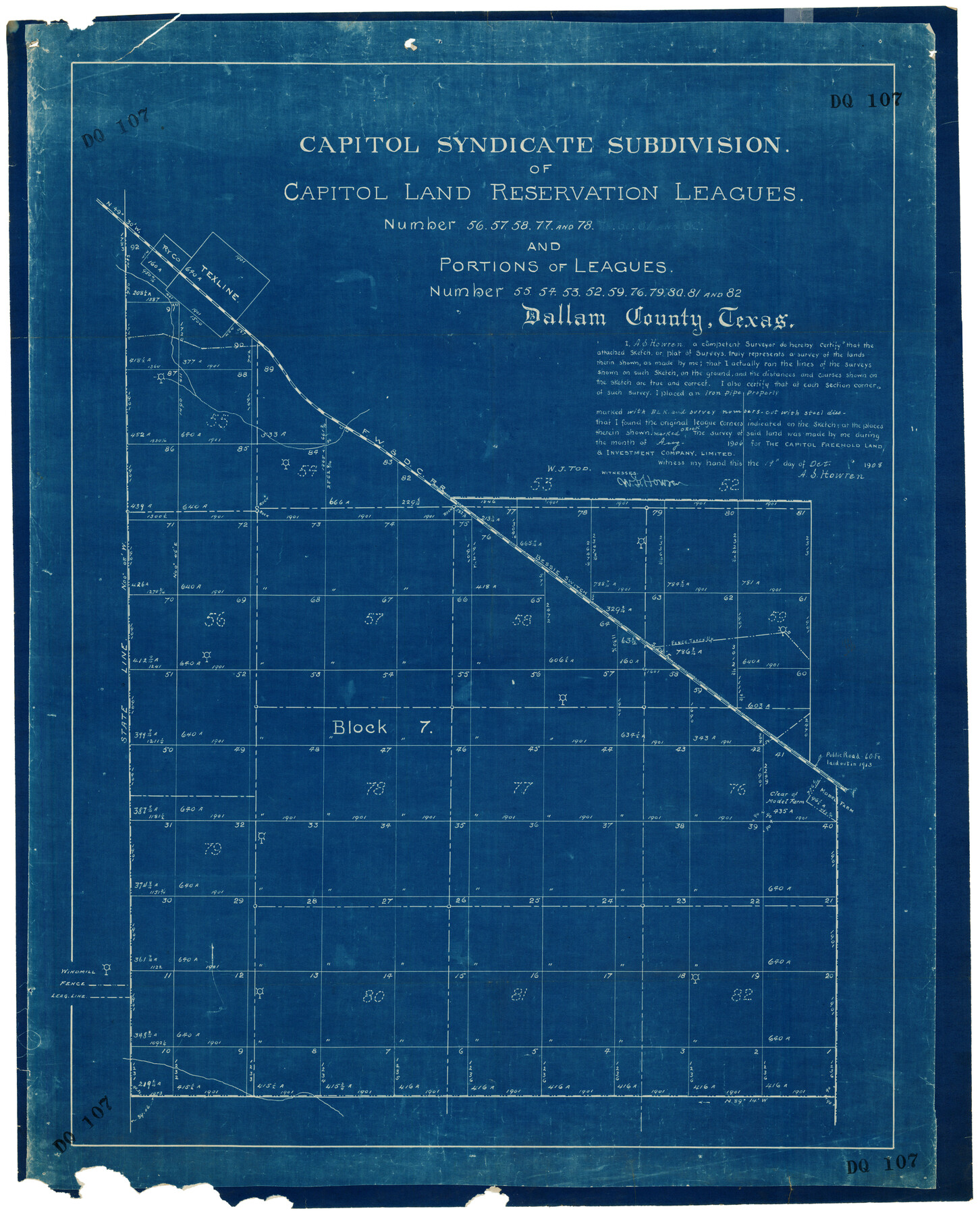
Capitol Syndicate Subdivision of Capitol Land Reservation Leagues
DQ107
-
Map/Doc
92584
-
Collection
Twichell Survey Records
-
Object Dates
10/19/1908 (Creation Date)
-
People and Organizations
A.S. Howren (Surveyor/Engineer)
-
Counties
Dallam
-
Height x Width
25.6 x 31.5 inches
65.0 x 80.0 cm
Part of: Twichell Survey Records
Map of Andrews

Print $20.00
- Digital $50.00
Map of Andrews
1928
Size 20.8 x 17.7 inches
Map/Doc 92452
Subdivision Map of Fisher County School Land situated in Bailey and Cochran Counties, Texas

Print $20.00
- Digital $50.00
Subdivision Map of Fisher County School Land situated in Bailey and Cochran Counties, Texas
1924
Size 20.0 x 29.6 inches
Map/Doc 90243
[Sketch Showing Wm. T. Brewer, John R. Taylor, Wm. F. Butler, Timothy DeVore, L. M. Thorn and adjoining surveys]
![89745, [Sketch Showing Wm. T. Brewer, John R. Taylor, Wm. F. Butler, Timothy DeVore, L. M. Thorn and adjoining surveys], Twichell Survey Records](https://historictexasmaps.com/wmedia_w700/maps/89745-1.tif.jpg)
Print $40.00
- Digital $50.00
[Sketch Showing Wm. T. Brewer, John R. Taylor, Wm. F. Butler, Timothy DeVore, L. M. Thorn and adjoining surveys]
Size 37.1 x 56.1 inches
Map/Doc 89745
Dumas, Moore County, Texas

Print $20.00
- Digital $50.00
Dumas, Moore County, Texas
1891
Size 13.4 x 15.7 inches
Map/Doc 92111
[E. T. Ry. Blk. 1]
![89796, [E. T. Ry. Blk. 1], Twichell Survey Records](https://historictexasmaps.com/wmedia_w700/maps/89796-1.tif.jpg)
Print $40.00
- Digital $50.00
[E. T. Ry. Blk. 1]
Size 41.1 x 50.4 inches
Map/Doc 89796
Seagraves Chamber of Commerce Subdivision of Northeast Quarter of Southeast Quarter of Section 9, Block C-34, Gaines County, Texas

Print $20.00
- Digital $50.00
Seagraves Chamber of Commerce Subdivision of Northeast Quarter of Southeast Quarter of Section 9, Block C-34, Gaines County, Texas
1955
Size 16.7 x 18.2 inches
Map/Doc 92684
Block G, Section 160, Gaines County, Texas

Print $20.00
- Digital $50.00
Block G, Section 160, Gaines County, Texas
Size 19.7 x 24.0 inches
Map/Doc 92649
[I. Killough and Hiram Cates surveys and vicinity]
![91845, [I. Killough and Hiram Cates surveys and vicinity], Twichell Survey Records](https://historictexasmaps.com/wmedia_w700/maps/91845-1.tif.jpg)
Print $3.00
- Digital $50.00
[I. Killough and Hiram Cates surveys and vicinity]
Size 16.9 x 10.5 inches
Map/Doc 91845
Tech Town a Subdivision of the Northeast Quarter Section 18, Block B

Print $20.00
- Digital $50.00
Tech Town a Subdivision of the Northeast Quarter Section 18, Block B
Size 17.5 x 21.6 inches
Map/Doc 92792
Map of Dalhart

Print $20.00
- Digital $50.00
Map of Dalhart
1905
Size 23.5 x 32.0 inches
Map/Doc 92146
Section A, Tech Memorial Park, Inc.

Print $20.00
- Digital $50.00
Section A, Tech Memorial Park, Inc.
Size 21.6 x 15.6 inches
Map/Doc 92785
[Stone, Kyle and Kyle Block M6]
![90414, [Stone, Kyle and Kyle Block M6], Twichell Survey Records](https://historictexasmaps.com/wmedia_w700/maps/90414-1.tif.jpg)
Print $20.00
- Digital $50.00
[Stone, Kyle and Kyle Block M6]
1908
Size 18.6 x 25.5 inches
Map/Doc 90414
You may also like
Hutchinson County Sketch File 38

Print $40.00
- Digital $50.00
Hutchinson County Sketch File 38
1935
Size 17.6 x 14.2 inches
Map/Doc 27280
National Map Company's New Road Survey of the United States Showing Main Highways

Print $20.00
- Digital $50.00
National Map Company's New Road Survey of the United States Showing Main Highways
Size 44.3 x 38.2 inches
Map/Doc 4674
J. De Cordova's Map of the State of Texas Compiled from the records of the General Land Office of the State

Print $20.00
J. De Cordova's Map of the State of Texas Compiled from the records of the General Land Office of the State
1853
Size 35.0 x 35.0 inches
Map/Doc 88903
Flight Mission No. CRE-2R, Frame 84, Jackson County

Print $20.00
- Digital $50.00
Flight Mission No. CRE-2R, Frame 84, Jackson County
1956
Size 16.1 x 15.9 inches
Map/Doc 85356
Maps of Gulf Intracoastal Waterway, Texas - Sabine River to the Rio Grande and connecting waterways including ship channels

Print $20.00
- Digital $50.00
Maps of Gulf Intracoastal Waterway, Texas - Sabine River to the Rio Grande and connecting waterways including ship channels
1966
Size 14.6 x 22.3 inches
Map/Doc 61938
Pecos County Sketch [University Blocks 19 and 20]
![2439, Pecos County Sketch [University Blocks 19 and 20], General Map Collection](https://historictexasmaps.com/wmedia_w700/maps/2439-1.tif.jpg)
Print $20.00
- Digital $50.00
Pecos County Sketch [University Blocks 19 and 20]
1951
Size 31.3 x 15.8 inches
Map/Doc 2439
Ward County Rolled Sketch 29

Print $20.00
- Digital $50.00
Ward County Rolled Sketch 29
Size 31.8 x 27.4 inches
Map/Doc 89287
Brewster County Rolled Sketch 129

Print $20.00
- Digital $50.00
Brewster County Rolled Sketch 129
1978
Size 24.4 x 15.3 inches
Map/Doc 5301
Jack County Working Sketch 23

Print $20.00
- Digital $50.00
Jack County Working Sketch 23
2006
Size 18.4 x 22.0 inches
Map/Doc 83606
Subdivision Map, Calhoun County School Land Leagues 1-4, Located in Hale and Floyd Counties

Print $20.00
- Digital $50.00
Subdivision Map, Calhoun County School Land Leagues 1-4, Located in Hale and Floyd Counties
Size 28.1 x 31.5 inches
Map/Doc 92660
Concho County Rolled Sketch 23

Print $20.00
- Digital $50.00
Concho County Rolled Sketch 23
1971
Size 22.8 x 22.4 inches
Map/Doc 78463
Pas Kaart van de Golff van Mexico

Print $20.00
- Digital $50.00
Pas Kaart van de Golff van Mexico
1695
Size 21.4 x 25.4 inches
Map/Doc 94081