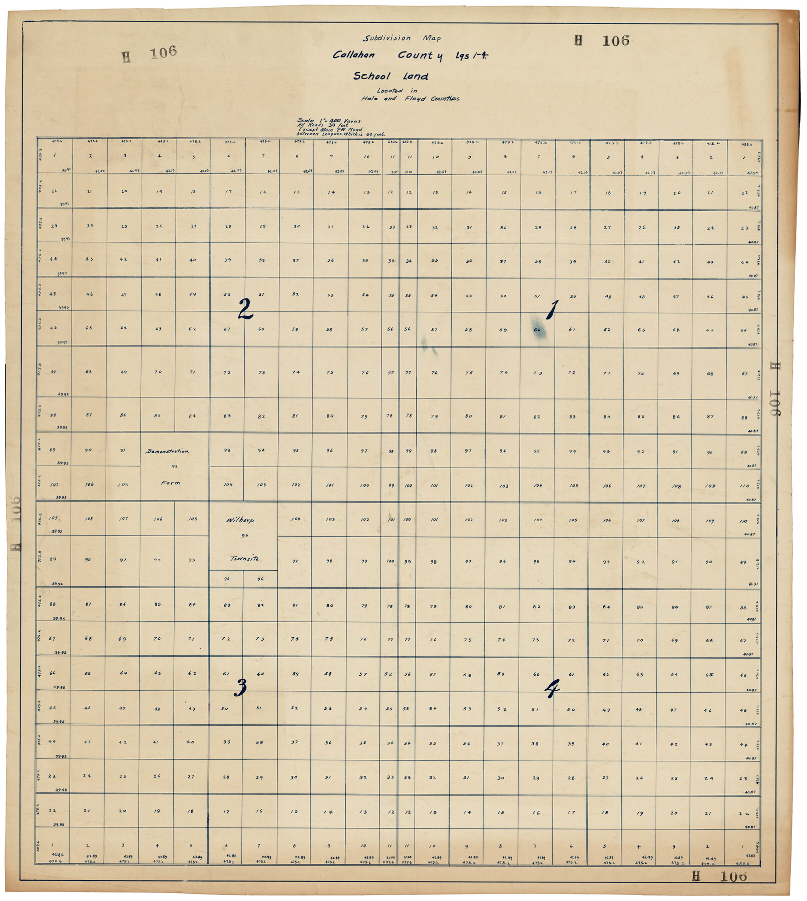
Subdivision Map, Calhoun County School Land Leagues 1-4, Located in Hale and Floyd Counties
H106
-
Map/Doc
92660
-
Collection
Twichell Survey Records
-
Counties
Hale Floyd
-
Height x Width
28.1 x 31.5 inches
71.4 x 80.0 cm
Part of: Twichell Survey Records
[Blocks O18, G. & M. Block 3 and Blocks B10, B11 and 47]
![91813, [Blocks O18, G. & M. Block 3 and Blocks B10, B11 and 47], Twichell Survey Records](https://historictexasmaps.com/wmedia_w700/maps/91813-1.tif.jpg)
Print $20.00
- Digital $50.00
[Blocks O18, G. & M. Block 3 and Blocks B10, B11 and 47]
Size 19.7 x 30.0 inches
Map/Doc 91813
[H. & T. C. Blocks 47 1/2 and 48, Capitol Lands]
![90639, [H. & T. C. Blocks 47 1/2 and 48, Capitol Lands], Twichell Survey Records](https://historictexasmaps.com/wmedia_w700/maps/90639-1.tif.jpg)
Print $20.00
- Digital $50.00
[H. & T. C. Blocks 47 1/2 and 48, Capitol Lands]
Size 19.9 x 24.8 inches
Map/Doc 90639
Plat of Land Purchased by C. W. Post in Hockley County, Texas

Print $20.00
- Digital $50.00
Plat of Land Purchased by C. W. Post in Hockley County, Texas
Size 18.4 x 14.5 inches
Map/Doc 91196
[Surveys along San Antonio Road]
![90110, [Surveys along San Antonio Road], Twichell Survey Records](https://historictexasmaps.com/wmedia_w700/maps/90110-1.tif.jpg)
Print $20.00
- Digital $50.00
[Surveys along San Antonio Road]
Size 23.0 x 13.7 inches
Map/Doc 90110
[Blocks D3, A, D7, and RG]
![92764, [Blocks D3, A, D7, and RG], Twichell Survey Records](https://historictexasmaps.com/wmedia_w700/maps/92764-1.tif.jpg)
Print $20.00
- Digital $50.00
[Blocks D3, A, D7, and RG]
Size 36.7 x 31.1 inches
Map/Doc 92764
[Portions of Blocks 3T, G. & M. Block 3, Block 47, and Block J]
![91522, [Portions of Blocks 3T, G. & M. Block 3, Block 47, and Block J], Twichell Survey Records](https://historictexasmaps.com/wmedia_w700/maps/91522-1.tif.jpg)
Print $20.00
- Digital $50.00
[Portions of Blocks 3T, G. & M. Block 3, Block 47, and Block J]
Size 16.0 x 23.1 inches
Map/Doc 91522
Map of Scurry County

Print $20.00
- Digital $50.00
Map of Scurry County
Size 17.8 x 22.7 inches
Map/Doc 92921
[Morris County School Land and vicinity]
![90360, [Morris County School Land and vicinity], Twichell Survey Records](https://historictexasmaps.com/wmedia_w700/maps/90360-1.tif.jpg)
Print $20.00
- Digital $50.00
[Morris County School Land and vicinity]
Size 14.2 x 13.0 inches
Map/Doc 90360
[E. T. Ry. Blk. 1]
![89796, [E. T. Ry. Blk. 1], Twichell Survey Records](https://historictexasmaps.com/wmedia_w700/maps/89796-1.tif.jpg)
Print $40.00
- Digital $50.00
[E. T. Ry. Blk. 1]
Size 41.1 x 50.4 inches
Map/Doc 89796
[Connecting line from southwest corner of S. K. & K. Blk M6 to southwest corner I. & G. N. Blk. 6]
![90411, [Connecting line from southwest corner of S. K. & K. Blk M6 to southwest corner I. & G. N. Blk. 6], Twichell Survey Records](https://historictexasmaps.com/wmedia_w700/maps/90411-1.tif.jpg)
Print $20.00
- Digital $50.00
[Connecting line from southwest corner of S. K. & K. Blk M6 to southwest corner I. & G. N. Blk. 6]
Size 26.4 x 26.9 inches
Map/Doc 90411
Working Sketch from Fisher County [around Roby]
![90911, Working Sketch from Fisher County [around Roby], Twichell Survey Records](https://historictexasmaps.com/wmedia_w700/maps/90911-1.tif.jpg)
Print $20.00
- Digital $50.00
Working Sketch from Fisher County [around Roby]
1901
Size 22.7 x 31.1 inches
Map/Doc 90911
Map of Young County

Print $20.00
- Digital $50.00
Map of Young County
Size 25.6 x 29.8 inches
Map/Doc 92023
You may also like
Map showing Center Lines on Holley St.

Print $3.00
- Digital $50.00
Map showing Center Lines on Holley St.
1912
Size 6.1 x 17.5 inches
Map/Doc 495
Haskell County Sketch File 3

Print $8.00
- Digital $50.00
Haskell County Sketch File 3
Size 9.8 x 8.8 inches
Map/Doc 26121
Cottle County Rolled Sketch 14

Print $741.00
- Digital $50.00
Cottle County Rolled Sketch 14
1882
Size 10.8 x 16.0 inches
Map/Doc 42369
El Paso County Rolled Sketch 18

Print $20.00
- Digital $50.00
El Paso County Rolled Sketch 18
Size 30.0 x 33.4 inches
Map/Doc 5822
Map of Galveston West Bay and Part of Galveston Island

Print $40.00
- Digital $50.00
Map of Galveston West Bay and Part of Galveston Island
1851
Size 31.2 x 52.6 inches
Map/Doc 69923
Kleberg County Rolled Sketch 10-22

Print $20.00
- Digital $50.00
Kleberg County Rolled Sketch 10-22
1952
Size 35.1 x 36.8 inches
Map/Doc 9376
La Salle County Sketch File 39

Print $6.00
- Digital $50.00
La Salle County Sketch File 39
1912
Size 16.4 x 11.4 inches
Map/Doc 29592
Military Map of Southwestern Texas

Print $20.00
Military Map of Southwestern Texas
1881
Size 24.3 x 38.4 inches
Map/Doc 76316
General Highway Map, Mason County, Texas

Print $20.00
General Highway Map, Mason County, Texas
1940
Size 18.2 x 24.5 inches
Map/Doc 79186
Map of Survey 7, Block 1, D.B. Gardner

Print $20.00
- Digital $50.00
Map of Survey 7, Block 1, D.B. Gardner
1915
Size 16.9 x 22.3 inches
Map/Doc 5067
Zavala County Working Sketch 9

Print $20.00
- Digital $50.00
Zavala County Working Sketch 9
1951
Size 42.0 x 36.4 inches
Map/Doc 62084
Delta County Sketch File 2

Print $4.00
- Digital $50.00
Delta County Sketch File 2
1871
Size 8.4 x 13.2 inches
Map/Doc 20670