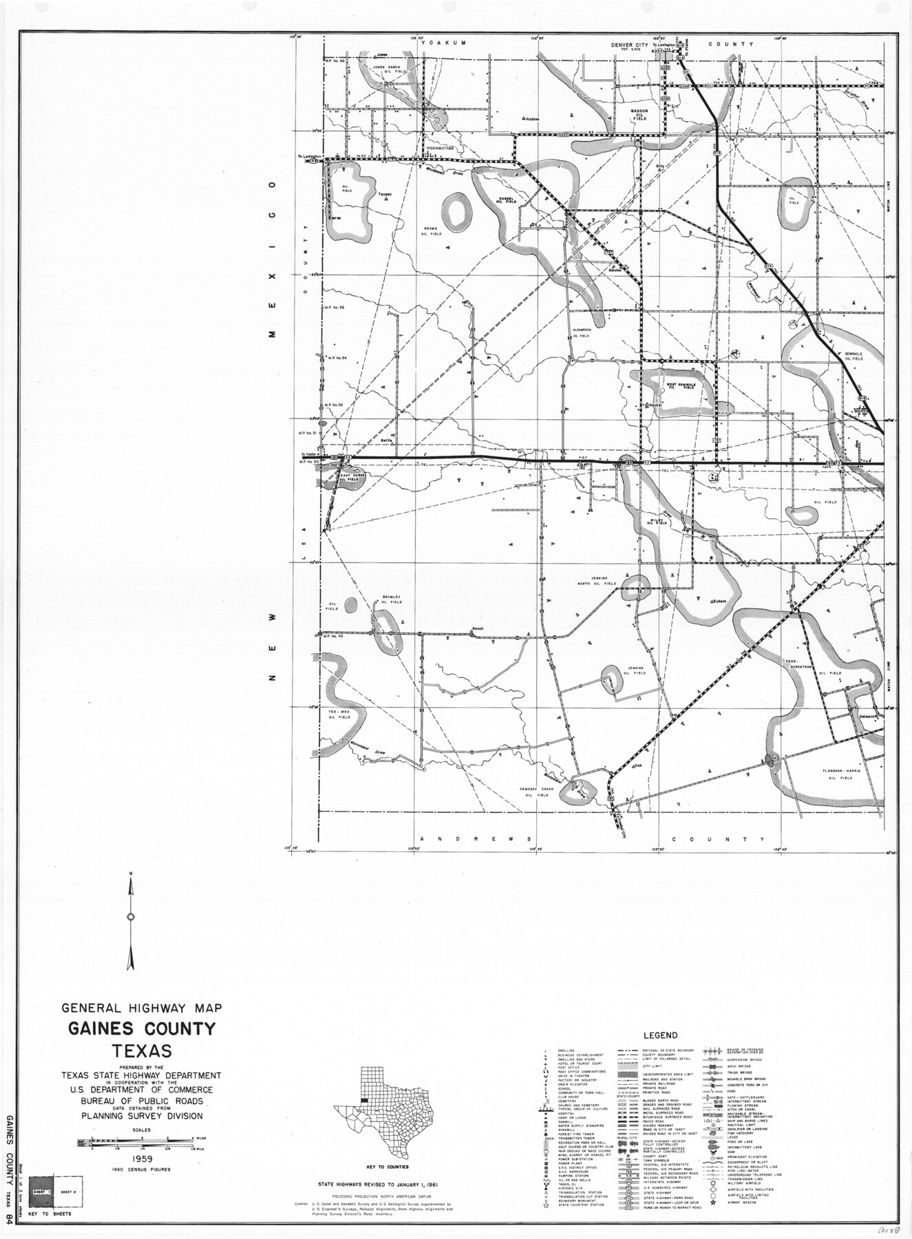
General Highway Map, Gaines County, Texas
-
Map/Doc
79474
-
Collection
Texas State Library and Archives
-
Object Dates
1961 (Creation Date)
-
People and Organizations
Texas State Highway Department (Publisher)
-
Counties
Gaines
-
Subjects
County
-
Height x Width
24.6 x 18.1 inches
62.5 x 46.0 cm
-
Comments
Prints available courtesy of the Texas State Library and Archives.
More info can be found here: TSLAC Map 05137
Part of: Texas State Library and Archives
General Highway Map, Erath County, Texas

Print $20.00
General Highway Map, Erath County, Texas
1940
Size 24.7 x 18.4 inches
Map/Doc 79086
Magnolia Road Map of Texas

Print $20.00
Magnolia Road Map of Texas
1933
Size 18.1 x 24.1 inches
Map/Doc 76301
General Highway Map, Marion County, Texas

Print $20.00
General Highway Map, Marion County, Texas
1940
Size 18.3 x 24.7 inches
Map/Doc 79184
General Highway Map, Floyd County, Texas

Print $20.00
General Highway Map, Floyd County, Texas
1940
Size 25.1 x 18.7 inches
Map/Doc 79091
General Highway Map, Montague County, Texas

Print $20.00
General Highway Map, Montague County, Texas
1961
Size 24.8 x 18.2 inches
Map/Doc 79601
General Highway Map, Kenedy County, Texas

Print $20.00
General Highway Map, Kenedy County, Texas
1940
Size 18.5 x 24.9 inches
Map/Doc 79154
General Highway Map, Tarrant County, Texas

Print $20.00
General Highway Map, Tarrant County, Texas
1961
Size 18.3 x 25.1 inches
Map/Doc 79664
General Highway Map, Collingsworth County, Texas

Print $20.00
General Highway Map, Collingsworth County, Texas
1961
Size 18.1 x 24.6 inches
Map/Doc 79415
Stanford's Map of the Seat of War in America

Print $40.00
Stanford's Map of the Seat of War in America
1861
Size 52.2 x 45.7 inches
Map/Doc 76231
General Highway Map, Starr County, Texas

Print $20.00
General Highway Map, Starr County, Texas
1940
Size 24.8 x 18.5 inches
Map/Doc 79246
General Highway Map. Detail of Cities and Towns in Montgomery County, Texas

Print $20.00
General Highway Map. Detail of Cities and Towns in Montgomery County, Texas
1961
Size 18.1 x 24.5 inches
Map/Doc 79603
General Highway Map, Lipscomb County, Texas

Print $20.00
General Highway Map, Lipscomb County, Texas
1940
Size 18.2 x 24.7 inches
Map/Doc 79175
You may also like
General Highway Map, Briscoe County, Texas

Print $20.00
General Highway Map, Briscoe County, Texas
1940
Size 18.5 x 24.9 inches
Map/Doc 79029
San Augustine County Working Sketch 6

Print $20.00
- Digital $50.00
San Augustine County Working Sketch 6
1935
Size 22.2 x 37.9 inches
Map/Doc 63693
Map of South Pacific Rail Road Co. of Missouri.

Print $20.00
Map of South Pacific Rail Road Co. of Missouri.
1870
Size 13.4 x 15.7 inches
Map/Doc 93613
General Highway Map, Shelby County, Texas

Print $20.00
General Highway Map, Shelby County, Texas
1961
Size 18.1 x 24.9 inches
Map/Doc 79652
Bosque County Sketch File 31

Print $6.00
- Digital $50.00
Bosque County Sketch File 31
1867
Size 8.5 x 10.5 inches
Map/Doc 14830
Gillespie County

Print $40.00
- Digital $50.00
Gillespie County
1945
Size 41.0 x 50.0 inches
Map/Doc 95507
Flight Mission No. CRC-2R, Frame 198, Chambers County

Print $20.00
- Digital $50.00
Flight Mission No. CRC-2R, Frame 198, Chambers County
1956
Size 18.7 x 22.4 inches
Map/Doc 84776
McCulloch County Sketch File 5

Print $11.00
- Digital $50.00
McCulloch County Sketch File 5
1899
Size 17.5 x 9.2 inches
Map/Doc 31177
Coryell County Rolled Sketch 1

Print $20.00
- Digital $50.00
Coryell County Rolled Sketch 1
1943
Size 22.7 x 21.4 inches
Map/Doc 5565
Wichita County Working Sketch 10

Print $20.00
- Digital $50.00
Wichita County Working Sketch 10
1920
Size 25.4 x 16.1 inches
Map/Doc 72519

W.D. Twichell's and R.S. Hunnicutt's Resurvey in Oldham County, Texas May to October 1915

Print $20.00
- Digital $50.00
W.D. Twichell's and R.S. Hunnicutt's Resurvey in Oldham County, Texas May to October 1915
1915
Size 47.6 x 38.3 inches
Map/Doc 89970