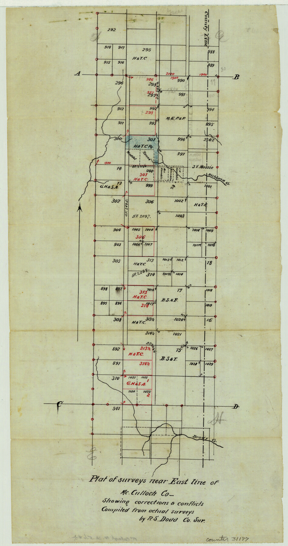
McCulloch County Sketch File 5
[Report on H. & T. C. RR. Co. surveys]
-
Map/Doc
31177
-
Collection
General Map Collection
-
Object Dates
7/12/1899 (Creation Date)
7/19/1899 (File Date)
7/7/1898 (Correspondence Date)
-
People and Organizations
Robert S. Dod (Surveyor/Engineer)
-
Counties
McCulloch San Saba
-
Subjects
Surveying Sketch File
-
Height x Width
17.5 x 9.2 inches
44.5 x 23.4 cm
-
Medium
paper, manuscript
-
Features
Richland Creek
Brady Creek
Colorado River
Brady
San Saba River
Part of: General Map Collection
Dawson County Working Sketch 14

Print $20.00
- Digital $50.00
Dawson County Working Sketch 14
1952
Size 15.5 x 12.8 inches
Map/Doc 68558
Freestone County Working Sketch 7

Print $20.00
- Digital $50.00
Freestone County Working Sketch 7
1951
Size 32.8 x 24.4 inches
Map/Doc 69249
Mason County Boundary File 6

Print $28.00
- Digital $50.00
Mason County Boundary File 6
Size 14.3 x 8.9 inches
Map/Doc 56874
Live Oak County Rolled Sketch 4

Print $20.00
- Digital $50.00
Live Oak County Rolled Sketch 4
1946
Size 27.7 x 32.1 inches
Map/Doc 6633

Presidio County Working Sketch 3

Print $20.00
- Digital $50.00
Presidio County Working Sketch 3
1914
Size 21.5 x 15.9 inches
Map/Doc 71677
PSL Field Notes for Block C24 in Loving and Winkler Counties, and Blocks C22 and C23 in Winkler County

PSL Field Notes for Block C24 in Loving and Winkler Counties, and Blocks C22 and C23 in Winkler County
Map/Doc 81677
Coleman County Working Sketch 15

Print $20.00
- Digital $50.00
Coleman County Working Sketch 15
1952
Size 24.3 x 18.1 inches
Map/Doc 68081
Pecos County Rolled Sketch 140

Print $20.00
- Digital $50.00
Pecos County Rolled Sketch 140
1954
Size 28.4 x 38.6 inches
Map/Doc 7275
Kimble County Rolled Sketch 17 1/2

Print $59.00
- Digital $50.00
Kimble County Rolled Sketch 17 1/2
1889
Size 27.0 x 38.3 inches
Map/Doc 6510

Rockwall County

Print $20.00
- Digital $50.00
Rockwall County
1941
Size 29.7 x 24.1 inches
Map/Doc 95628
You may also like
Gillespie County

Print $40.00
- Digital $50.00
Gillespie County
1945
Size 39.7 x 48.4 inches
Map/Doc 73157
Gillespie County Sketch File 3

Print $4.00
- Digital $50.00
Gillespie County Sketch File 3
1847
Size 11.2 x 8.0 inches
Map/Doc 24129
Flight Mission No. CLL-1N, Frame 109, Willacy County

Print $20.00
- Digital $50.00
Flight Mission No. CLL-1N, Frame 109, Willacy County
1954
Size 18.3 x 22.1 inches
Map/Doc 87043
United States - Gulf Coast - Galveston to Rio Grande

Print $20.00
- Digital $50.00
United States - Gulf Coast - Galveston to Rio Grande
Size 27.8 x 18.1 inches
Map/Doc 72740
Pecos County Rolled Sketch 59

Print $20.00
- Digital $50.00
Pecos County Rolled Sketch 59
1922
Size 16.6 x 17.0 inches
Map/Doc 7231
La Salle County Sketch File 14

Print $4.00
- Digital $50.00
La Salle County Sketch File 14
Size 6.4 x 6.7 inches
Map/Doc 29483
Galveston County Sketch File 11

Print $40.00
- Digital $50.00
Galveston County Sketch File 11
Size 16.3 x 13.2 inches
Map/Doc 23374
Jack County Sketch File 18a

Print $4.00
- Digital $50.00
Jack County Sketch File 18a
Size 8.0 x 12.8 inches
Map/Doc 27555
Cherokee County Sketch File 34

Print $12.00
- Digital $50.00
Cherokee County Sketch File 34
1954
Size 11.2 x 8.9 inches
Map/Doc 18198
Copy of Surveyor's Field Book, Morris Browning - In Blocks 7, 5 & 4, I&GNRRCo., Hutchinson and Carson Counties, Texas

Print $2.00
- Digital $50.00
Copy of Surveyor's Field Book, Morris Browning - In Blocks 7, 5 & 4, I&GNRRCo., Hutchinson and Carson Counties, Texas
1888
Size 6.8 x 8.8 inches
Map/Doc 62274

Zapata County Working Sketch 12

Print $20.00
- Digital $50.00
Zapata County Working Sketch 12
1960
Size 30.8 x 24.4 inches
Map/Doc 62063