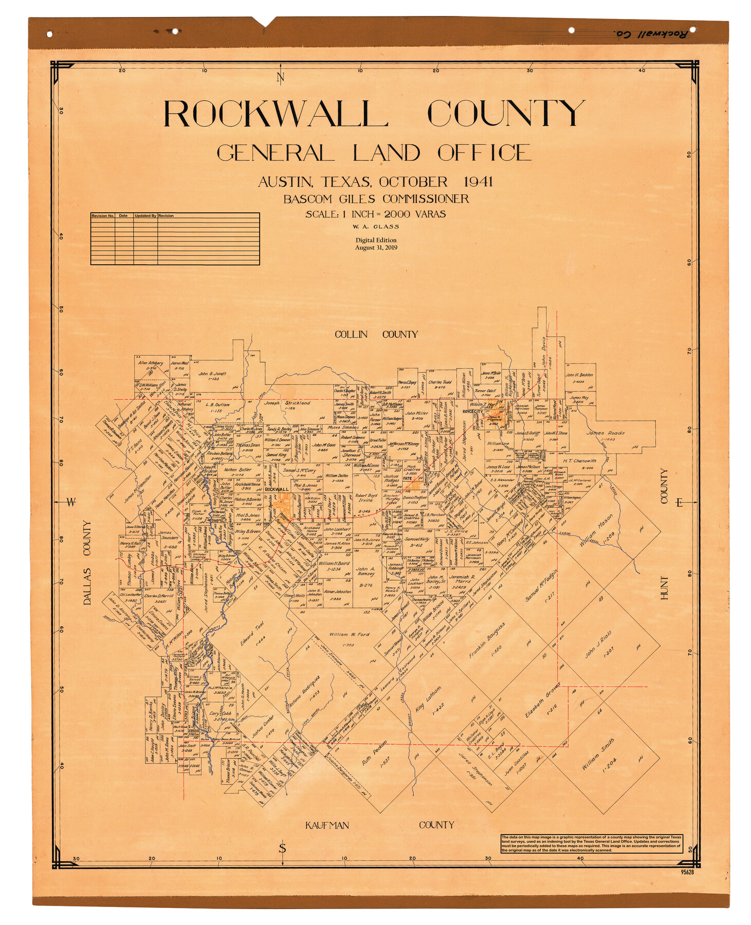
Rockwall County
General Land Office Official County Map
-
Map/Doc
95628
-
Collection
General Map Collection
-
Object Dates
2019/8/31 (Revision Date)
1941 (Creation Date)
-
People and Organizations
Cheyenne Betancourt (Draftsman)
W.A. Glass (Draftsman)
Bascom Giles (GLO Commissioner)
-
Counties
Rockwall
-
Subjects
County OCM
-
Height x Width
29.7 x 24.1 inches
75.4 x 61.2 cm
-
Medium
digital image
-
Scale
1" = 2000 varas
Part of: General Map Collection
Bastrop County Sketch File 9A

Print $40.00
- Digital $50.00
Bastrop County Sketch File 9A
Map/Doc 88484
United States - Gulf Coast Texas - Southern part of Laguna Madre

Print $20.00
- Digital $50.00
United States - Gulf Coast Texas - Southern part of Laguna Madre
1941
Size 26.5 x 18.3 inches
Map/Doc 72955
Flight Mission No. DQN-2K, Frame 25, Calhoun County

Print $20.00
- Digital $50.00
Flight Mission No. DQN-2K, Frame 25, Calhoun County
1953
Size 18.8 x 22.4 inches
Map/Doc 84232
Andrews County Working Sketch 11

Print $20.00
- Digital $50.00
Andrews County Working Sketch 11
1955
Size 20.6 x 25.2 inches
Map/Doc 67057
Burnet County Sketch File 10

Print $4.00
- Digital $50.00
Burnet County Sketch File 10
1848
Size 12.8 x 8.4 inches
Map/Doc 16690
Jefferson County Working Sketch 9

Print $20.00
- Digital $50.00
Jefferson County Working Sketch 9
1937
Size 19.5 x 22.0 inches
Map/Doc 66552
Jackson County Sketch File 27

Print $20.00
- Digital $50.00
Jackson County Sketch File 27
1938
Size 25.6 x 24.8 inches
Map/Doc 11847
McMullen County Sketch File 15

Print $4.00
- Digital $50.00
McMullen County Sketch File 15
1876
Size 10.0 x 8.0 inches
Map/Doc 31363
Winkler County

Print $20.00
- Digital $50.00
Winkler County
1932
Size 39.4 x 38.7 inches
Map/Doc 73328
McCulloch County Rolled Sketch 5

Print $20.00
- Digital $50.00
McCulloch County Rolled Sketch 5
Size 25.7 x 20.9 inches
Map/Doc 6716
Scurry County

Print $20.00
- Digital $50.00
Scurry County
1921
Size 41.4 x 38.1 inches
Map/Doc 73286
Harrison County Working Sketch 7

Print $20.00
- Digital $50.00
Harrison County Working Sketch 7
1955
Size 32.0 x 39.0 inches
Map/Doc 66027
You may also like
Sabine River, Merrill Lake Sheet

Print $20.00
- Digital $50.00
Sabine River, Merrill Lake Sheet
1933
Size 26.4 x 43.6 inches
Map/Doc 65137
Val Verde County Sketch File Z18

Print $4.00
- Digital $50.00
Val Verde County Sketch File Z18
1910
Size 14.0 x 8.8 inches
Map/Doc 39148
Winkler County Working Sketch 10

Print $40.00
- Digital $50.00
Winkler County Working Sketch 10
1960
Size 30.3 x 61.0 inches
Map/Doc 72604
Rachford's Complete Map of the City of Beaumont

Print $20.00
- Digital $50.00
Rachford's Complete Map of the City of Beaumont
1897
Size 33.4 x 23.6 inches
Map/Doc 97355
Gillespie County

Print $20.00
- Digital $50.00
Gillespie County
1877
Size 20.1 x 24.5 inches
Map/Doc 3583
Runnels County Sketch File 25

Print $20.00
Runnels County Sketch File 25
1940
Size 16.5 x 16.7 inches
Map/Doc 12259
Texas, nach den besten Quellen entw. u. gez. vom Hauptm. Radefeld

Print $20.00
- Digital $50.00
Texas, nach den besten Quellen entw. u. gez. vom Hauptm. Radefeld
1851
Size 15.0 x 18.4 inches
Map/Doc 93776
Chambers County Rolled Sketch CL

Print $40.00
- Digital $50.00
Chambers County Rolled Sketch CL
1909
Size 56.2 x 21.0 inches
Map/Doc 8610
Pecos County Sketch File 28a

Print $14.00
- Digital $50.00
Pecos County Sketch File 28a
1911
Size 14.5 x 8.9 inches
Map/Doc 33683
Archer County

Print $20.00
- Digital $50.00
Archer County
1926
Size 42.9 x 37.8 inches
Map/Doc 73070
Flight Mission No. CRC-3R, Frame 18, Chambers County

Print $20.00
- Digital $50.00
Flight Mission No. CRC-3R, Frame 18, Chambers County
1956
Size 18.7 x 22.4 inches
Map/Doc 84792
[Blocks B, T, and 1]
![90972, [Blocks B, T, and 1], Twichell Survey Records](https://historictexasmaps.com/wmedia_w700/maps/90972-1.tif.jpg)
Print $2.00
- Digital $50.00
[Blocks B, T, and 1]
Size 9.2 x 13.7 inches
Map/Doc 90972