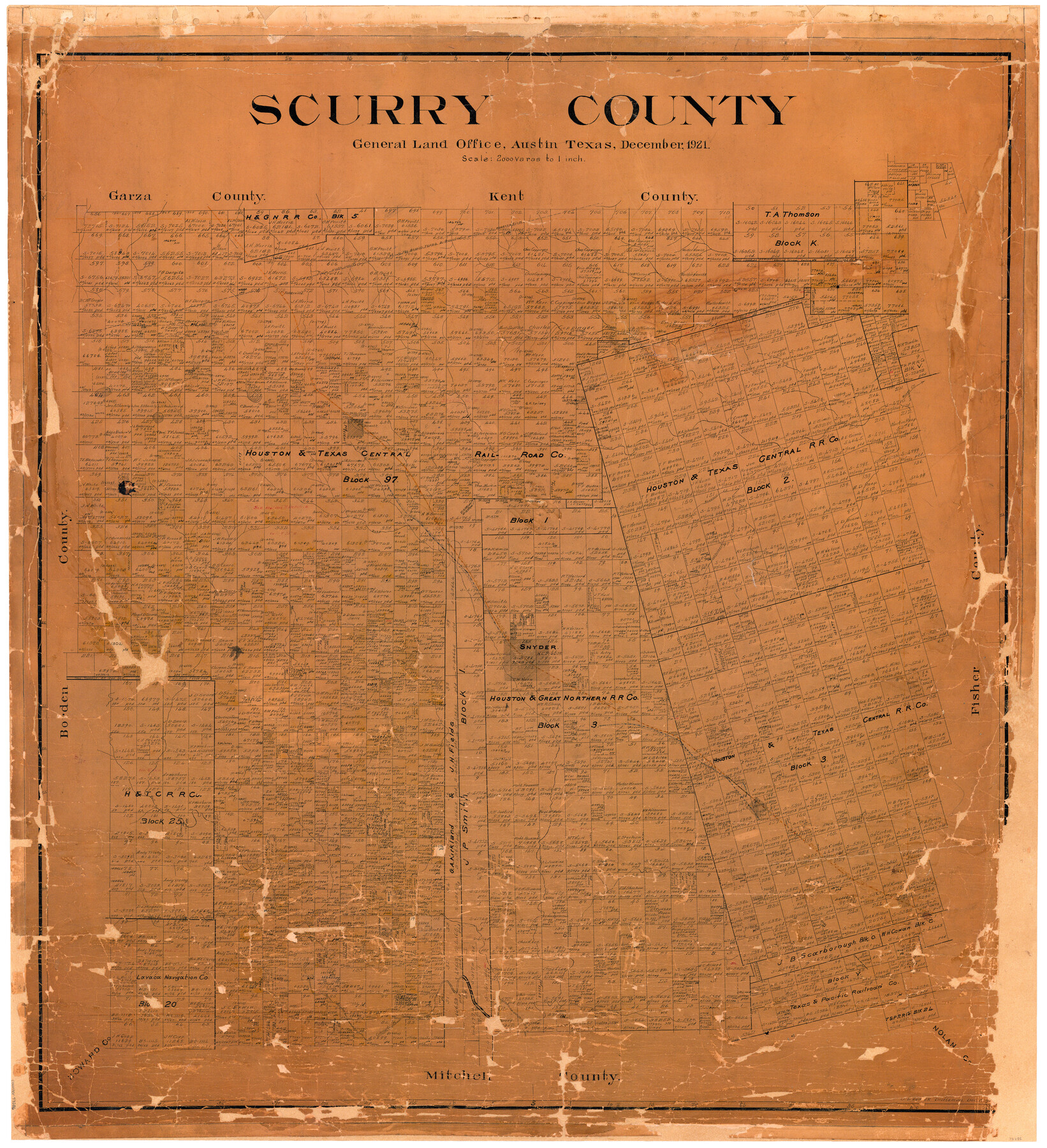
Scurry County
-
Map/Doc
73286
-
Collection
General Map Collection
-
Object Dates
1921 (Creation Date)
-
People and Organizations
Texas General Land Office (Publisher)
John D. Hedick (Draftsman)
-
Counties
Scurry
-
Subjects
County
-
Height x Width
41.4 x 38.1 inches
105.2 x 96.8 cm
-
Comments
Conservation funded in 2007 by Friends of the Texas General Land Office.
Note on reverse side: "Compiled and drawn by J. D. Hedick. Began October 20, 1921. Filed December 17, 1921. Replaced [on sticks] by cloth copy November 2, 1949." -
Features
P&NT
Cottonwood Creek
Dunn Post Office
Colorado River
Pyron
Beasley
Bull Creek
Chorn
Snyder
Cox's Hollow
Deep Creek
Rockwall Creek
Brand
RS&P
Rough Creek
Ennis Creek
Dermott
Fullerville
Part of: General Map Collection
Travis County Working Sketch 58

Print $20.00
- Digital $50.00
Travis County Working Sketch 58
1946
Size 36.4 x 43.0 inches
Map/Doc 69442

Clay County Sketch File 18

Print $4.00
- Digital $50.00
Clay County Sketch File 18
1875
Size 12.6 x 8.4 inches
Map/Doc 18427
Louisiana and Texas Intracoastal Waterway

Print $20.00
- Digital $50.00
Louisiana and Texas Intracoastal Waterway
1939
Size 14.0 x 19.6 inches
Map/Doc 83346
Val Verde County Rolled Sketch 59

Print $20.00
- Digital $50.00
Val Verde County Rolled Sketch 59
1947
Size 45.2 x 23.6 inches
Map/Doc 10078
Zapata County Rolled Sketch 7

Print $20.00
- Digital $50.00
Zapata County Rolled Sketch 7
1912
Size 18.1 x 27.9 inches
Map/Doc 8308
Pecos County Boundary File 1b

Print $8.00
- Digital $50.00
Pecos County Boundary File 1b
Size 14.2 x 8.5 inches
Map/Doc 57861
Kenedy County Rolled Sketch 10

Print $20.00
- Digital $50.00
Kenedy County Rolled Sketch 10
1915
Size 21.7 x 35.7 inches
Map/Doc 6470
Edwards County Sketch File 10

Print $40.00
- Digital $50.00
Edwards County Sketch File 10
Size 26.3 x 19.0 inches
Map/Doc 11421
Travis County Appraisal District Plat Map 2_1004

Print $20.00
- Digital $50.00
Travis County Appraisal District Plat Map 2_1004
Size 21.4 x 26.5 inches
Map/Doc 94238
Nueces County Sketch File 14

Print $20.00
- Digital $50.00
Nueces County Sketch File 14
Size 18.3 x 20.8 inches
Map/Doc 42179
Flight Mission No. DAG-21K, Frame 117, Matagorda County

Print $20.00
- Digital $50.00
Flight Mission No. DAG-21K, Frame 117, Matagorda County
1952
Size 18.5 x 22.4 inches
Map/Doc 86440
You may also like
Brazos River, Sandpit Special Sheet

Print $6.00
- Digital $50.00
Brazos River, Sandpit Special Sheet
1936
Size 33.8 x 24.7 inches
Map/Doc 65279
Bee County Sketch File 33

Print $56.00
- Digital $50.00
Bee County Sketch File 33
Size 11.3 x 8.9 inches
Map/Doc 14349
Newton County Sketch File 25

Print $4.00
- Digital $50.00
Newton County Sketch File 25
Size 7.8 x 8.3 inches
Map/Doc 32407
Knox County Sketch File 10

Print $20.00
- Digital $50.00
Knox County Sketch File 10
1889
Size 20.1 x 12.8 inches
Map/Doc 11958
Travis County Sketch File 69A

Print $20.00
- Digital $50.00
Travis County Sketch File 69A
Size 18.0 x 20.9 inches
Map/Doc 12476
Famous Heights Addition to Amarillo, Potter Co. Texas

Print $20.00
- Digital $50.00
Famous Heights Addition to Amarillo, Potter Co. Texas
Size 18.6 x 10.0 inches
Map/Doc 91744
[Map showing T&P Lands in El Paso County]
![88930, [Map showing T&P Lands in El Paso County], Library of Congress](https://historictexasmaps.com/wmedia_w700/maps/88930.tif.jpg)
Print $20.00
[Map showing T&P Lands in El Paso County]
Size 17.5 x 22.3 inches
Map/Doc 88930
Flight Mission No. CLL-1N, Frame 83, Willacy County

Print $20.00
- Digital $50.00
Flight Mission No. CLL-1N, Frame 83, Willacy County
1954
Size 18.3 x 22.0 inches
Map/Doc 87029
Goliad County Sketch File 1

Print $24.00
- Digital $50.00
Goliad County Sketch File 1
1857
Size 12.5 x 7.5 inches
Map/Doc 24211
Amistad International Reservoir on Rio Grande 65

Print $20.00
- Digital $50.00
Amistad International Reservoir on Rio Grande 65
1949
Size 28.2 x 39.8 inches
Map/Doc 73350
Cochran County Sketch File 6

Print $10.00
- Digital $50.00
Cochran County Sketch File 6
1938
Size 11.2 x 8.6 inches
Map/Doc 18545
Dimmit County

Print $40.00
- Digital $50.00
Dimmit County
1916
Size 40.0 x 48.8 inches
Map/Doc 66806