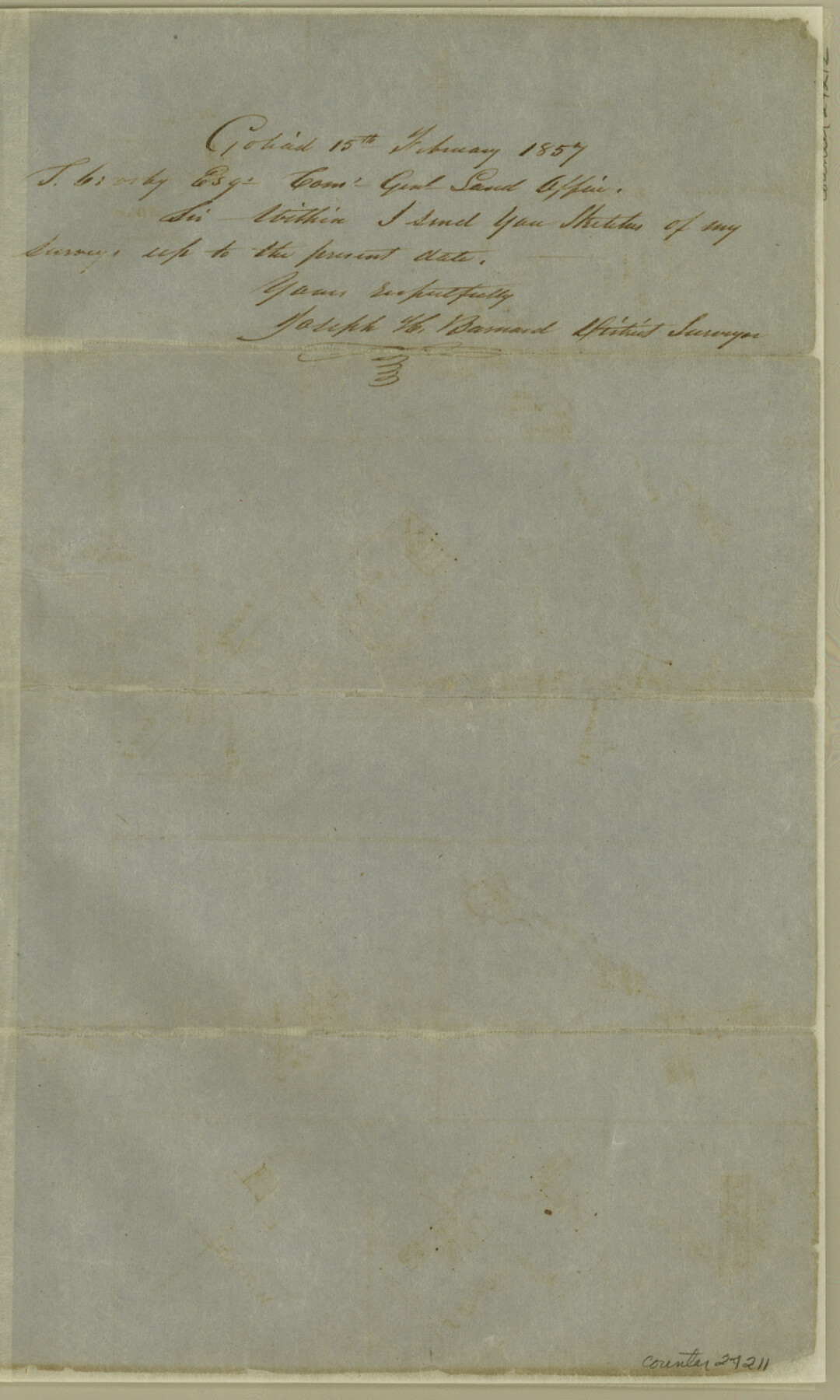
Goliad County Sketch File 1
[Multiple sketches of surveys all over the county]
-
Map/Doc
24211
-
Collection
General Map Collection
-
Object Dates
1857/2/15 (Creation Date)
1857/2/24 (File Date)
-
People and Organizations
Joseph H. Barnard (Surveyor/Engineer)
-
Counties
Goliad Bee
-
Subjects
Surveying Sketch File
-
Height x Width
12.5 x 7.5 inches
31.8 x 19.1 cm
-
Medium
paper, manuscript
-
Features
Medio Creek
[Amedia Creek]
Spring Creek
[Road] to San Patricio
Paesta Creek
Aransas Creek
[Road] to Fort Merrill
[Road] to Oakville
Tapalcate Creek
Mustang Creek
Old Mill Road
Cadinach Creek
Manahuilla Creek
Johnson Creek
Eye Creek
Cabeza Creek
San Antonio River
Live Oak Branch of San Antonio River
Part of: General Map Collection
Map of San Augustine County

Print $20.00
- Digital $50.00
Map of San Augustine County
1839
Size 22.3 x 18.2 inches
Map/Doc 4011
San Patricio County Working Sketch 7

Print $20.00
- Digital $50.00
San Patricio County Working Sketch 7
1936
Size 18.3 x 15.9 inches
Map/Doc 63769
Nueces County Sketch File 33

Print $20.00
- Digital $50.00
Nueces County Sketch File 33
1908
Size 22.0 x 19.2 inches
Map/Doc 42188
Flight Mission No. BRA-16M, Frame 105, Jefferson County

Print $20.00
- Digital $50.00
Flight Mission No. BRA-16M, Frame 105, Jefferson County
1953
Size 18.5 x 22.1 inches
Map/Doc 85717
Hudspeth County Rolled Sketch 40

Print $20.00
- Digital $50.00
Hudspeth County Rolled Sketch 40
1937
Size 11.5 x 38.9 inches
Map/Doc 9213
Flight Mission No. DAG-21K, Frame 31, Matagorda County

Print $20.00
- Digital $50.00
Flight Mission No. DAG-21K, Frame 31, Matagorda County
1952
Size 18.7 x 22.4 inches
Map/Doc 86398
Wharton County Sketch File 26

Print $4.00
- Digital $50.00
Wharton County Sketch File 26
1895
Size 11.0 x 8.8 inches
Map/Doc 39990
Galveston County NRC Article 33.136 Sketch 24

Print $22.00
- Digital $50.00
Galveston County NRC Article 33.136 Sketch 24
2003
Size 24.8 x 36.3 inches
Map/Doc 87919
Texas State Boundary Line 9

Print $174.00
Texas State Boundary Line 9
2000
Size 11.3 x 8.8 inches
Map/Doc 75076
Dimmit County Sketch File 47

Print $24.00
- Digital $50.00
Dimmit County Sketch File 47
1908
Size 11.2 x 9.0 inches
Map/Doc 21178
Brooks County Rolled Sketch 18

Print $20.00
- Digital $50.00
Brooks County Rolled Sketch 18
Size 11.3 x 16.1 inches
Map/Doc 61786
Travis County Sketch File 41

Print $22.00
- Digital $50.00
Travis County Sketch File 41
1928
Size 11.7 x 30.2 inches
Map/Doc 12465
You may also like
[Map Showing Surveys in Dimmit & La Salle Counties, Texas]
![75792, [Map Showing Surveys in Dimmit & La Salle Counties, Texas], Maddox Collection](https://historictexasmaps.com/wmedia_w700/maps/75792.tif.jpg)
Print $20.00
- Digital $50.00
[Map Showing Surveys in Dimmit & La Salle Counties, Texas]
1882
Size 32.6 x 28.7 inches
Map/Doc 75792
Eastland County Working Sketch 4

Print $20.00
- Digital $50.00
Eastland County Working Sketch 4
1918
Size 39.1 x 29.1 inches
Map/Doc 68785
Limestone County Working Sketch 7

Print $20.00
- Digital $50.00
Limestone County Working Sketch 7
1922
Size 33.2 x 17.0 inches
Map/Doc 70557
[Capitol Leagues in Lamb County]
![91013, [Capitol Leagues in Lamb County], Twichell Survey Records](https://historictexasmaps.com/wmedia_w700/maps/91013-1.tif.jpg)
Print $2.00
- Digital $50.00
[Capitol Leagues in Lamb County]
1912
Size 13.1 x 8.8 inches
Map/Doc 91013
Flight Mission No. CRC-1R, Frame 152, Chambers County

Print $20.00
- Digital $50.00
Flight Mission No. CRC-1R, Frame 152, Chambers County
1956
Size 18.8 x 22.5 inches
Map/Doc 84714
Texas Gulf Coast from the Sabine River to the Rio Grande Showing Location of Navigation Districts

Print $20.00
- Digital $50.00
Texas Gulf Coast from the Sabine River to the Rio Grande Showing Location of Navigation Districts
1954
Size 45.0 x 43.8 inches
Map/Doc 73596
Pecos County Rolled Sketch 81

Print $20.00
- Digital $50.00
Pecos County Rolled Sketch 81
1930
Size 35.9 x 25.4 inches
Map/Doc 7240
Zavala County Rolled Sketch 25

Print $20.00
- Digital $50.00
Zavala County Rolled Sketch 25
1952
Size 38.4 x 43.4 inches
Map/Doc 10176
Flight Mission No. DCL-7C, Frame 19, Kenedy County

Print $20.00
- Digital $50.00
Flight Mission No. DCL-7C, Frame 19, Kenedy County
1943
Size 15.4 x 15.2 inches
Map/Doc 86011
Gray County, Texas

Print $20.00
- Digital $50.00
Gray County, Texas
1889
Size 23.7 x 17.4 inches
Map/Doc 630
Flight Mission No. DQN-1K, Frame 104, Calhoun County

Print $20.00
- Digital $50.00
Flight Mission No. DQN-1K, Frame 104, Calhoun County
1953
Size 18.4 x 22.1 inches
Map/Doc 84171
Brewster County Working Sketch 32

Print $20.00
- Digital $50.00
Brewster County Working Sketch 32
1943
Size 28.3 x 28.3 inches
Map/Doc 67566