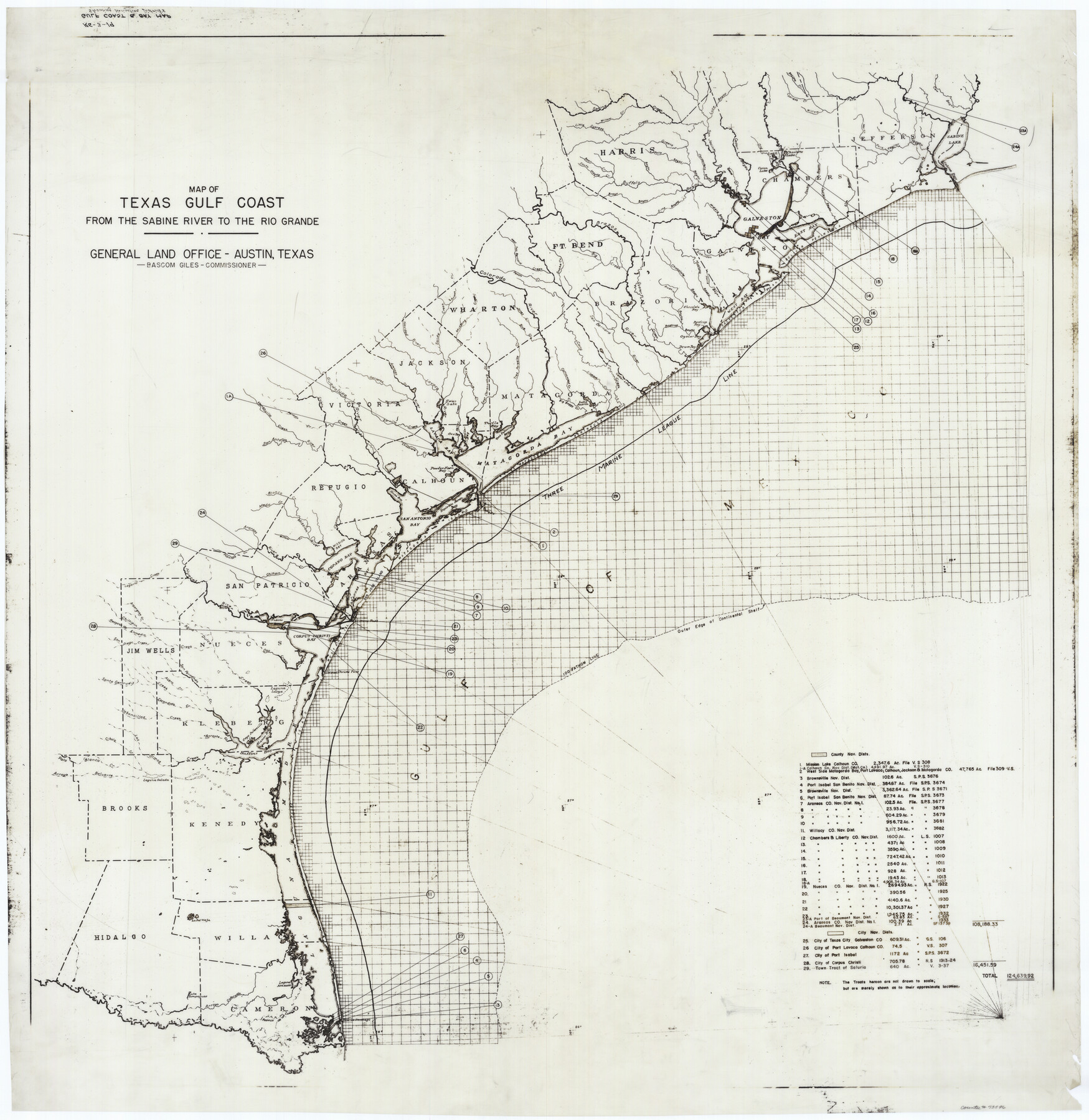
Texas Gulf Coast from the Sabine River to the Rio Grande Showing Location of Navigation Districts
Gulf Coast and Bay Map Showing Navigation Districts
-
Map/Doc
73596
-
Collection
General Map Collection
-
Object Dates
1954 (Creation Date)
-
People and Organizations
General Land Office (Publisher)
-
Counties
Orange Jefferson Chambers Galveston Brazoria
-
Subjects
Energy Offshore Submerged Area Gulf of Mexico
-
Height x Width
45.0 x 43.8 inches
114.3 x 111.3 cm
-
Scale
8 miles
-
Comments
Key map for Mineral Development showing Navigation Districts from the Sabine River to the Rio Grande. Coastline includes these counties: Orange, Jefferson, Chambers, Harris, Galveston, Brazoria, Matagorda, Calhoun, Refugio, Aransas, Nueces, Kleberg, Ken
Part of: General Map Collection
Concho County Sketch File 46

Print $24.00
- Digital $50.00
Concho County Sketch File 46
1961
Size 14.2 x 8.6 inches
Map/Doc 19213
El Paso County Rolled Sketch 43B

Print $20.00
- Digital $50.00
El Paso County Rolled Sketch 43B
Size 22.0 x 22.0 inches
Map/Doc 5830
Zavala County

Print $40.00
- Digital $50.00
Zavala County
1977
Size 43.6 x 49.3 inches
Map/Doc 95684
Current Miscellaneous File 83

Print $2.00
- Digital $50.00
Current Miscellaneous File 83
1936
Size 8.3 x 10.6 inches
Map/Doc 74226
Andrews County Working Sketch 13

Print $20.00
- Digital $50.00
Andrews County Working Sketch 13
1956
Size 37.3 x 30.6 inches
Map/Doc 67059
Frio County Sketch File 12

Print $18.00
- Digital $50.00
Frio County Sketch File 12
1938
Size 14.2 x 8.7 inches
Map/Doc 23127
Bee County Sketch File 2

Print $40.00
- Digital $50.00
Bee County Sketch File 2
Size 14.3 x 13.0 inches
Map/Doc 14259
Flight Mission No. DAG-21K, Frame 97, Matagorda County

Print $20.00
- Digital $50.00
Flight Mission No. DAG-21K, Frame 97, Matagorda County
1952
Size 18.4 x 22.2 inches
Map/Doc 86426
Atascosa County Working Sketch 32

Print $20.00
- Digital $50.00
Atascosa County Working Sketch 32
1981
Size 12.9 x 11.8 inches
Map/Doc 67228
Marion County Working Sketch 45

Print $20.00
- Digital $50.00
Marion County Working Sketch 45
2005
Size 27.0 x 29.2 inches
Map/Doc 83576
Potter County Boundary File 5a

Print $80.00
- Digital $50.00
Potter County Boundary File 5a
Size 13.0 x 71.0 inches
Map/Doc 58024
Travis County Working Sketch 9

Print $20.00
- Digital $50.00
Travis County Working Sketch 9
1918
Size 21.9 x 28.9 inches
Map/Doc 69393
You may also like

Flight Mission No. CRC-2R, Frame 195, Chambers County

Print $20.00
- Digital $50.00
Flight Mission No. CRC-2R, Frame 195, Chambers County
1956
Size 18.6 x 22.3 inches
Map/Doc 84773
Flight Mission No. BQY-4M, Frame 55, Harris County

Print $20.00
- Digital $50.00
Flight Mission No. BQY-4M, Frame 55, Harris County
1953
Size 18.5 x 22.3 inches
Map/Doc 85264
Gregg County Boundary File 3

Print $8.00
- Digital $50.00
Gregg County Boundary File 3
Size 14.1 x 8.5 inches
Map/Doc 53988
Pecos County Working Sketch 98

Print $20.00
- Digital $50.00
Pecos County Working Sketch 98
1970
Size 42.8 x 31.8 inches
Map/Doc 71571
Erath County Sketch File 28

Print $40.00
- Digital $50.00
Erath County Sketch File 28
1895
Size 16.5 x 12.0 inches
Map/Doc 22309
Harris County Working Sketch 52

Print $20.00
- Digital $50.00
Harris County Working Sketch 52
1947
Size 33.9 x 42.4 inches
Map/Doc 65944
Flight Mission No. CUG-3P, Frame 170, Kleberg County

Print $20.00
- Digital $50.00
Flight Mission No. CUG-3P, Frame 170, Kleberg County
1956
Size 18.6 x 22.2 inches
Map/Doc 86290
Hutchinson County Rolled Sketch 44-6

Print $20.00
- Digital $50.00
Hutchinson County Rolled Sketch 44-6
2002
Size 24.0 x 36.0 inches
Map/Doc 77542
Hamilton County Working Sketch 35

Print $20.00
- Digital $50.00
Hamilton County Working Sketch 35
Size 26.3 x 19.1 inches
Map/Doc 78286
Medina County Rolled Sketch 3

Print $40.00
- Digital $50.00
Medina County Rolled Sketch 3
Size 40.9 x 54.5 inches
Map/Doc 9504
Map of Nacogdoches County

Print $20.00
- Digital $50.00
Map of Nacogdoches County
1881
Size 25.2 x 20.7 inches
Map/Doc 4601