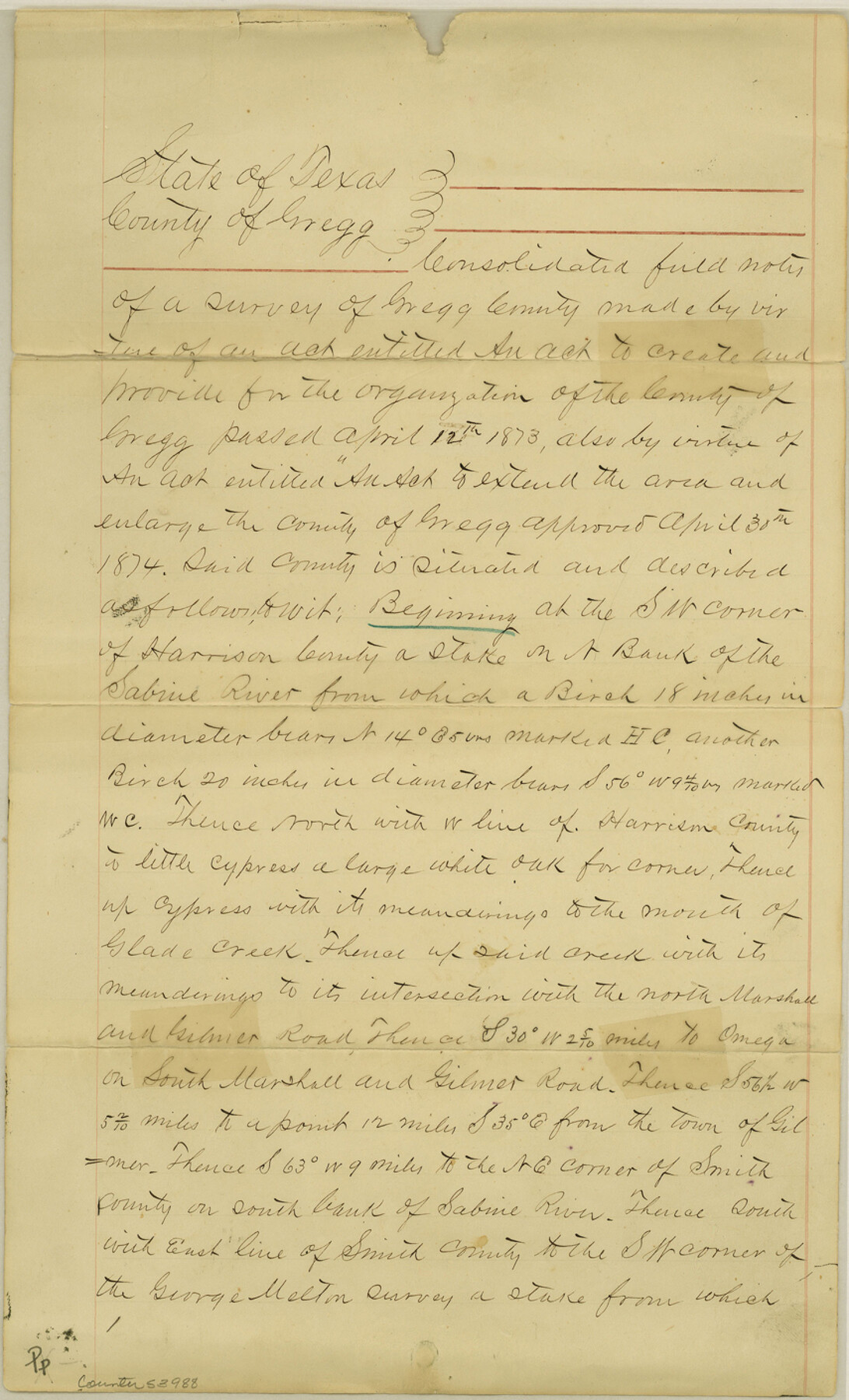
Gregg County Boundary File 3
A. P. Taylor's line of Gregg Co.
-
Map/Doc
53988
-
Collection
General Map Collection
-
Counties
Gregg
-
Subjects
County Boundaries
-
Height x Width
14.1 x 8.5 inches
35.8 x 21.6 cm
Part of: General Map Collection
Dallas County Boundary File 3

Print $6.00
- Digital $50.00
Dallas County Boundary File 3
Size 14.2 x 8.6 inches
Map/Doc 52120
Briscoe County Sketch File 2

Print $40.00
- Digital $50.00
Briscoe County Sketch File 2
1880
Size 18.3 x 15.4 inches
Map/Doc 10991
Sketch E No. 3 Shewing the progress of the Survey at North & South Edisto Rivers and St. Helena Sound, South Carolina

Print $20.00
- Digital $50.00
Sketch E No. 3 Shewing the progress of the Survey at North & South Edisto Rivers and St. Helena Sound, South Carolina
1852
Size 10.9 x 19.5 inches
Map/Doc 97215
[Kansas City, Mexico & Orient] Plat Showing Sections 10 & 17, Block 351, GC & SF Ry. Survey, Presidio County, Texas
![64270, [Kansas City, Mexico & Orient] Plat Showing Sections 10 & 17, Block 351, GC & SF Ry. Survey, Presidio County, Texas, General Map Collection](https://historictexasmaps.com/wmedia_w700/maps/64270-1.tif.jpg)
Print $20.00
- Digital $50.00
[Kansas City, Mexico & Orient] Plat Showing Sections 10 & 17, Block 351, GC & SF Ry. Survey, Presidio County, Texas
Size 17.6 x 16.0 inches
Map/Doc 64270
Uvalde County Working Sketch 64

Print $20.00
- Digital $50.00
Uvalde County Working Sketch 64
1998
Size 29.9 x 30.6 inches
Map/Doc 72134
Flight Mission No. CRK-5P, Frame 129, Refugio County

Print $20.00
- Digital $50.00
Flight Mission No. CRK-5P, Frame 129, Refugio County
1956
Size 18.4 x 22.3 inches
Map/Doc 86932
Leon County Sketch File 6

Print $4.00
- Digital $50.00
Leon County Sketch File 6
1859
Size 8.2 x 12.0 inches
Map/Doc 29719
Floyd County Working Sketch 8

Print $20.00
- Digital $50.00
Floyd County Working Sketch 8
1931
Size 20.8 x 15.9 inches
Map/Doc 69187
Schleicher County Rolled Sketch 16

Print $20.00
- Digital $50.00
Schleicher County Rolled Sketch 16
Size 27.4 x 29.0 inches
Map/Doc 7758
Colorado County Boundary File 1

Print $8.00
- Digital $50.00
Colorado County Boundary File 1
Size 14.0 x 8.6 inches
Map/Doc 51768
El Paso County Rolled Sketch 51

Print $40.00
- Digital $50.00
El Paso County Rolled Sketch 51
Size 42.9 x 75.3 inches
Map/Doc 8877
Henderson County Sketch File 22

Print $14.00
- Digital $50.00
Henderson County Sketch File 22
1942
Size 14.2 x 8.9 inches
Map/Doc 26365
You may also like
Crosby County

Print $20.00
- Digital $50.00
Crosby County
1892
Size 13.2 x 15.4 inches
Map/Doc 90495
Edwards County Working Sketch 105

Print $40.00
- Digital $50.00
Edwards County Working Sketch 105
1972
Size 54.9 x 36.2 inches
Map/Doc 62186
Blanco County Working Sketch 44

Print $20.00
- Digital $50.00
Blanco County Working Sketch 44
2000
Size 19.5 x 35.6 inches
Map/Doc 67404
Denton County Texas

Print $20.00
- Digital $50.00
Denton County Texas
1896
Size 18.4 x 31.6 inches
Map/Doc 4530
Jackson County Sketch File 12

Print $20.00
- Digital $50.00
Jackson County Sketch File 12
1907
Size 12.3 x 20.7 inches
Map/Doc 11838
Galveston County

Print $40.00
- Digital $50.00
Galveston County
1939
Size 45.0 x 56.5 inches
Map/Doc 95505
Gillespie County

Print $40.00
- Digital $50.00
Gillespie County
1887
Size 44.1 x 59.7 inches
Map/Doc 16835
Ellis County Sketch File 23

Print $4.00
- Digital $50.00
Ellis County Sketch File 23
1873
Size 10.3 x 8.3 inches
Map/Doc 21881
Flight Mission No. BRA-16M, Frame 141, Jefferson County

Print $20.00
- Digital $50.00
Flight Mission No. BRA-16M, Frame 141, Jefferson County
1953
Size 18.6 x 22.2 inches
Map/Doc 85747
South Umbarger in Randall County, Texas

Print $20.00
- Digital $50.00
South Umbarger in Randall County, Texas
1905
Size 31.2 x 30.7 inches
Map/Doc 92153
Real County Working Sketch 61

Print $20.00
- Digital $50.00
Real County Working Sketch 61
1964
Size 37.9 x 44.5 inches
Map/Doc 71953
Bailey County Working Sketch 2

Print $20.00
- Digital $50.00
Bailey County Working Sketch 2
1920
Size 17.8 x 16.2 inches
Map/Doc 67589