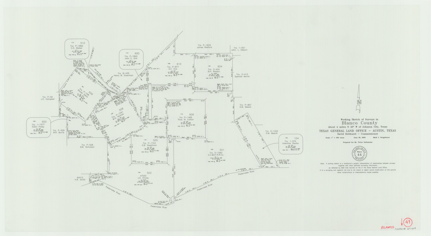
Blanco County Working Sketch 44
-
Map/Doc
67404
-
Collection
General Map Collection
-
Object Dates
6/26/2000 (Creation Date)
-
People and Organizations
Mark Neugebauer (Draftsman)
David Dewhurst (GLO Commissioner)
-
Counties
Blanco
-
Subjects
Surveying Working Sketch
-
Height x Width
19.5 x 35.6 inches
49.5 x 90.4 cm
-
Scale
1" = 300 varas
-
Comments
Surveys located about four miles North 45 degrees West of Johnson City, Texas.
Part of: General Map Collection
Nueces County Rolled Sketch 36

Print $199.00
- Digital $50.00
Nueces County Rolled Sketch 36
Size 10.7 x 15.2 inches
Map/Doc 47617
Nueces County Rolled Sketch 106

Print $104.00
Nueces County Rolled Sketch 106
1986
Size 18.2 x 24.6 inches
Map/Doc 7097
Flight Mission No. DCL-6C, Frame 96, Kenedy County

Print $20.00
- Digital $50.00
Flight Mission No. DCL-6C, Frame 96, Kenedy County
1943
Size 18.6 x 22.4 inches
Map/Doc 85926
Liberty County Sketch File 19

Print $6.00
- Digital $50.00
Liberty County Sketch File 19
1859
Size 13.6 x 9.4 inches
Map/Doc 29923
170th Anniversary Land Commissioners of the Texas General Land Office

Print $20.00
- Digital $50.00
170th Anniversary Land Commissioners of the Texas General Land Office
2006
Size 36.4 x 24.1 inches
Map/Doc 87177
Collingsworth County Rolled Sketch 1

Print $40.00
- Digital $50.00
Collingsworth County Rolled Sketch 1
1941
Size 58.0 x 27.0 inches
Map/Doc 8637
Hill County Sketch File 8

Print $4.00
- Digital $50.00
Hill County Sketch File 8
1859
Size 10.1 x 8.2 inches
Map/Doc 26472
Cameron County Boundary File 4

Print $42.00
- Digital $50.00
Cameron County Boundary File 4
Size 10.4 x 8.2 inches
Map/Doc 51110
Lavaca County Working Sketch 3

Print $20.00
- Digital $50.00
Lavaca County Working Sketch 3
1928
Size 22.8 x 27.2 inches
Map/Doc 70356
Pecos County Sketch File 27c

Print $4.00
- Digital $50.00
Pecos County Sketch File 27c
Size 11.1 x 9.1 inches
Map/Doc 33681
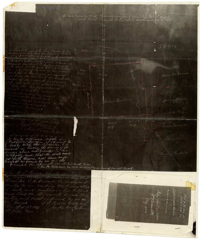
Newton County Rolled Sketch 23
Print $20.00
- Digital $50.00
Newton County Rolled Sketch 23
1893
Size 22.7 x 18.5 inches
Map/Doc 6850
Matagorda County NRC Article 33.136 Sketch 20

Print $106.00
Matagorda County NRC Article 33.136 Sketch 20
2024
Map/Doc 97425
You may also like
Hemphill County Working Sketch 15

Print $20.00
- Digital $50.00
Hemphill County Working Sketch 15
1969
Size 20.2 x 20.0 inches
Map/Doc 66110
Sabine Pass and Lake

Print $20.00
- Digital $50.00
Sabine Pass and Lake
1925
Size 43.6 x 28.0 inches
Map/Doc 69821
Cottle County Working Sketch Graphic Index

Print $20.00
- Digital $50.00
Cottle County Working Sketch Graphic Index
1971
Size 41.8 x 33.8 inches
Map/Doc 76506
![91800, [Block M-19], Twichell Survey Records](https://historictexasmaps.com/wmedia_w700/maps/91800-1.tif.jpg)
Sterling County Rolled Sketch 38

Print $20.00
- Digital $50.00
Sterling County Rolled Sketch 38
1988
Size 25.0 x 31.7 inches
Map/Doc 7863
Plat Showing Parts of Blocks X, Y, and Z, W.D. and F. W. Johnson Subdivision

Print $20.00
- Digital $50.00
Plat Showing Parts of Blocks X, Y, and Z, W.D. and F. W. Johnson Subdivision
1955
Size 25.7 x 16.5 inches
Map/Doc 92501
Crockett County Working Sketch 22

Print $20.00
- Digital $50.00
Crockett County Working Sketch 22
1920
Size 25.6 x 19.5 inches
Map/Doc 68355
Sabine County Sketch File 10

Print $4.00
Sabine County Sketch File 10
1873
Size 8.3 x 10.2 inches
Map/Doc 35627
Bailey County Sketch File 10

Print $4.00
- Digital $50.00
Bailey County Sketch File 10
Size 14.1 x 8.7 inches
Map/Doc 13965
Sutton County Sketch File 7

Print $4.00
- Digital $50.00
Sutton County Sketch File 7
Size 10.6 x 8.7 inches
Map/Doc 37365

Flight Mission No. DQN-2K, Frame 187, Calhoun County

Print $20.00
- Digital $50.00
Flight Mission No. DQN-2K, Frame 187, Calhoun County
1953
Size 18.4 x 22.2 inches
Map/Doc 84328